

In the Leaving Certificate syllabus, coastal processes form one of four surface-process options for detailed study in Core Unit 1 (section 1.5), alongside fluvial, glacial, and mass movement processes. Coastal human interaction is likewise an option in section 1.7. Coasts are dynamic boundaries shaped by the opposing forces of marine erosion, transportation, and deposition, driven by wind energy and wave action. Over longer geological timescales, coastlines also adjust to sea-level shifts through isostatic and eustatic changes, creating features of emergence and submergence. Managing these coastlines requires balancing protective engineering against natural sediment flows and human recreational pressures.
Wave Action and Wave Refraction
Waves are formed by wind blowing over the surface of the sea. Friction between the wind and the water transfers energy to the water, causing water particles to move in circular orbits. The size and energy of a wave depend on three factors: the speed of the wind, the length of time the wind blows, and the fetch (the distance of open sea over which the wind blows uninterrupted). Ireland's west coast faces the open North Atlantic Ocean with a fetch exceeding 5,000 km, generating powerful, high-energy swells.
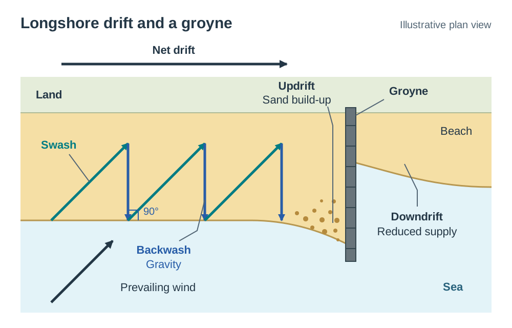
As a wave moves into shallow coastal water, friction against the sea floor slows the base of the wave. The crest continues moving forward, steepens, and eventually topples over or breaks. The rush of foaming water up the beach is called the swash. The water that drains back down the shore under gravity is the backwash.
Waves are classified into two main types:
- Constructive waves: Low, gentle waves (usually under 1 metre high) with a low frequency of 6 to 8 waves per minute. Their swash is stronger than their backwash. Because much of the swash water soaks into the sand and shingle, the weaker backwash cannot haul the material back out. These waves deposit sediment, building up beaches during calmer summer months.
- Destructive waves: High, steep waves (frequently over 2 metres) that plunge onto the shore at 10 to 14 waves per minute. Their backwash is stronger than their swash. The powerful backwash scours sand and shingle from the shore and drags it seaward, eroding the coast during stormy winter periods.
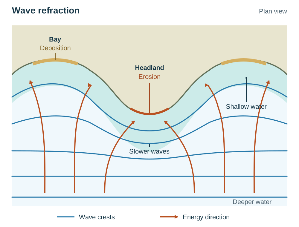
Wave refraction is the bending of waves as they approach an irregular coast. When a wave crest nears a shore with alternating headlands and bays, the section in front of the headland hits shallow water first and slows down. The sections travelling through the deeper water of adjacent bays keep moving at full speed. This difference in velocity bends the wave crest around the headland. As a result, wave energy is concentrated directly onto headlands, while waves diverge and lose energy in the sheltered bays, leading to deposition.
Processes of Coastal Erosion
Destructive waves erode the coast through five processes, which usually operate at the same time. Four of them attack the rock itself; attrition wears down the loose material the sea carries:
- Hydraulic action: The sheer physical impact of crashing water against rock faces. Storm waves can slam against cliffs with huge pressure, prising open joints and dislodging blocks of rock.
- Compression: When a wave crashes against a fissure or crack, air inside is trapped and compressed under intense pressure. As the wave pulls back, the trapped air expands rapidly with explosive force. This repeated cycle shatters the surrounding bedrock and widens the fissure.
- Abrasion (corrasion): Waves lift sand, pebbles, and boulders from the seabed and hurl them repeatedly against the cliff base. This sandpapering action scours, gouges, and undercuts the rock face.
- Attrition: The progressive wearing down of the sea's own load. As loose rocks, pebbles, and boulders collide with one another in the surf, they become smaller, smoother, and rounder over time. Attrition modifies the sediment itself rather than eroding the cliff face directly.
- Solution (corrosion): Weak carbonic acid in seawater chemically dissolves soluble minerals in rocks such as limestone and chalk along bedding planes and joints.
Landforms of Coastal Erosion
Marine erosion produces a characteristic sequence of landforms depending on wave power, fault lines, and rock resistance.
Headlands and Bays
Headlands and bays develop on a discordant coastline, where bands of resistant and weaker rock meet the coast at right angles. Waves carry out differential erosion: weaker rocks erode more quickly and retreat inland to form curved, sheltered bays, while resistant rocks withstand erosion and protrude seaward as elevated headlands. In south-west Ireland, resistant Old Red Sandstone forms long peninsulas and headlands, while weaker Carboniferous limestone and shale formed lowland valleys between them. These valleys were later drowned by rising sea level, so large bays such as Bantry Bay are also rias (see Changes in Sea Level).
Sea Cliffs and Wave-Cut Platforms
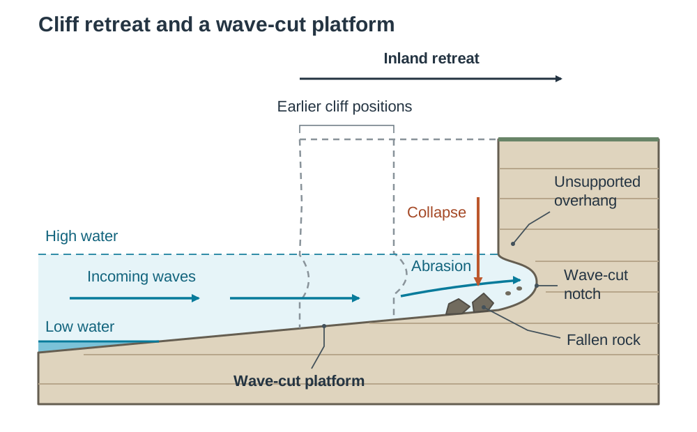
A cliff is a steep or vertical rock face formed by marine undercutting. Destructive waves direct hydraulic action and abrasion between high- and low-water marks, carving an indent called a wave-cut notch. As this notch deepens, the overhanging rock loses its support and collapses into the sea under gravity.
Through repeated collapse, the cliff face retreats inland (coastal retreat). Cliff retreat leaves behind a gently sloping rock platform at the foot of the cliff, planed smooth by abrasion and exposed at low tide: the wave-cut platform. As this platform widens seaward over time, it forces incoming waves to break further out, absorbing their energy and eventually slowing down cliff retreat. A classic Irish cliff example is the Cliffs of Moher in County Clare, which rise to over 200 metres in layered sandstone, siltstone, and shale.
Headland Erosion Sequence: Cave, Arch, Stack, and Stump
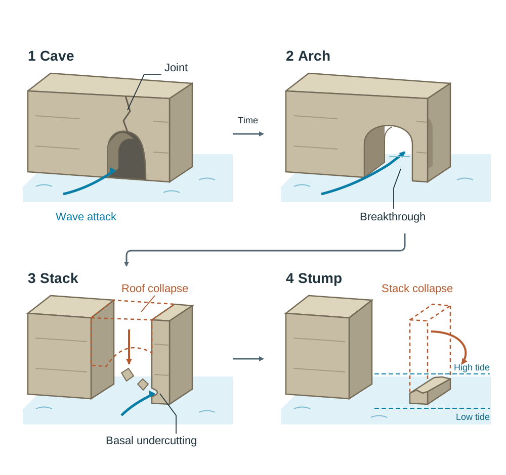
Wave refraction focuses destructive wave energy onto weaknesses in rocky headlands, driving a four-stage evolutionary sequence:
- Sea cave: Waves exploit a fault, joint, or bedding plane through hydraulic action and compression, hollowing out a tunnel.
- Sea arch: When two caves cut through from opposite sides of a narrow headland to meet, or when a single cave burrows entirely through, an archway is opened.
- Sea stack: Continued abrasion undercuts the base of the arch while sub-aerial weathering (such as freeze-thaw action) weakens the roof. When the roof collapses, an isolated pillar of rock remains standing offshore as a sea stack. An Irish example is Dún Briste at Downpatrick Head, County Mayo.
- Sea stump: Ongoing wave undercutting attacks the base of the sea stack until it topples over, leaving behind a low rock stump visible mainly at low tide.
Blowholes and Geos
Where compressed air and hydraulic action blast upward along a vertical master joint in the roof of a sea cave, the roof can breach through to the clifftop to form a blowhole (such as McSwyne's Gun near Horn Head, County Donegal). During storm conditions, high-pressure spray is hurled up through the vent. When the entire roof of a long sea cave subsequently collapses, it leaves behind a steep, narrow coastal inlet known as a geo.
Marine Transportation and Longshore Drift
The sea's load consists of eroded rock debris alongside sediment brought down by rivers. Particles are moved individually by traction, saltation, suspension, and solution. The major system moving material along the shore, however, is longshore drift.
The direction of longshore drift depends on the direction the dominant waves come from, so it varies from one stretch of coast to another. For any exam case study, you should learn the local direction of drift.
How to Draw and Describe the Longshore Drift Diagram
In an exam answer, you can sketch and annotate the process using these clear elements:
- Draw the coastline running horizontally across the page, with the sea below and the land above.
- Draw an arrow showing the prevailing wind approaching the shore at an oblique angle (e.g. 45°).
- Draw the swash arrow carrying sand and pebbles diagonally up the beach face at that same angle.
- Draw the backwash arrow pulling material straight down the beach slope at a 90° angle to the shore, driven purely by gravity.
- Connect these arrows to illustrate the resulting zigzag trajectory of sediment along the beach.
- Add a groyne built at a 90° angle across the beach, showing sand piling up on the updrift side while the downdrift side is starved of sediment.
Landforms of Coastal Deposition
Coastal deposition occurs in low-energy environments, such as sheltered bays or points where a sudden change in coastal direction allows longshore drift to deposit sediment into calmer water.
Beaches and Sand Dunes
A beach is an accumulation of sediment deposited by constructive waves between low water and the highest storm mark. Beach material is sorted naturally:
- Backshore: The upper, steeper section reached only by storm waves, made up of coarse pebbles, shingle, and distinct ridges called berms.
- Foreshore: The lower, intertidal zone, gently sloping and dominated by finer sand, marked by low sand ridges separated by shallow troughs called runnels.
Behind sandy beaches, onshore winds blow dry sand inland. Where obstacles trap the sand, hills of sand called dunes develop. Marram grass (Ammophila arenaria) colonises these dunes. Its extensive, deep root network binds the loose sand grains together, trapping further sand and stabilising the dune ridge.
Sandspits, Tombolos, Baymouth Bars, and Lagoons
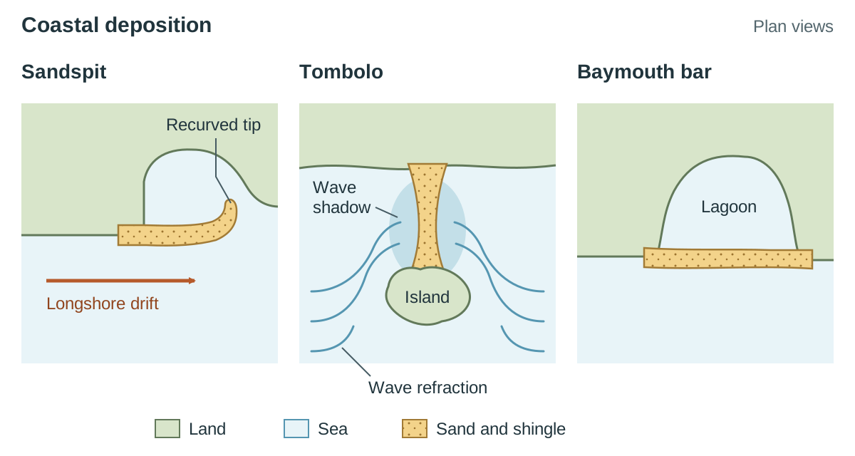
- Sandspit: An elongated ridge of sand and shingle joined to the mainland at one end and projecting out into open water. When the coastline bends abruptly into an estuary or bay, longshore drift continues straight ahead into deeper, calmer water. Wave energy falls in the deeper, sheltered water, so the waves can no longer carry their load and the sediment is deposited on the sea floor. Over time, deposition builds the ridge above high tide. Refracted waves or crosswinds often curve the distal end inland to create a recurved spit. A classic Irish example is Inch Spit in Castlemaine Harbour, County Kerry.
- Tombolo: A depositional spit or ridge that connects the mainland to an offshore island. Wave refraction around both sides of an island creates an area of calm water (a wave shadow) behind it. Sediment settles in this sheltered area until a continuous causeway connects the island to the shore. A well-known Irish example joins Howth Head to the Dublin mainland.
- Baymouth bar and lagoon: When a sandspit extends completely across a sheltered bay without being cut through by a river current, it connects two headlands together to form a baymouth bar. The body of calm, brackish water cut off from the sea is called a lagoon. Over time, silt accumulates and turns the lagoon into a salt marsh. An Irish example is Our Lady's Island in County Wexford.
Changes in Sea Level: Coasts of Emergence and Submergence
Coastlines are not permanent fixtures. The level of the sea relative to the land changes over time through two distinct mechanisms, which are studied under isostasy and base-level adjustment (Core Unit 1, section 1.6):
- Eustatic change: A global rise or fall in sea level itself. During glacial periods, huge volumes of ocean water were frozen into continental ice sheets, causing global sea level to drop. When the climate warmed and ice sheets melted, sea level rose globally.
- Isostatic change: The local rising or sinking of the earth's crust. During the Ice Age, the immense weight of ice sheets depressed the crust down into the mantle. When the ice melted, the weight was removed and the crust slowly rose back up in a process called isostatic rebound. Today, northern Ireland is still experiencing slow isostatic rise, whereas southern Ireland is tilting downward slightly.
Features of Emergence (Land Rising Relative to Sea Level)
Where the land has risen or sea level has fallen, ancient marine features are stranded high above the reach of modern waves:
- Raised beach: An ancient beach platform composed of sand, shingle, and marine shells, now situated well above the high-tide level of present waves. Examples are seen along the Inishowen Peninsula and Malin Head, County Donegal.
- Raised sea cliff and wave-cut platform: Relic cliffs and wave-cut platforms stranded inland behind the raised beach, with their ancient wave-cut notches and sea caves cut off from wave action.
Features of Submergence (Sea Level Rising Relative to the Land)
Where sea level has risen relative to the crust, coastal river valleys and glacial troughs are drowned by the sea:
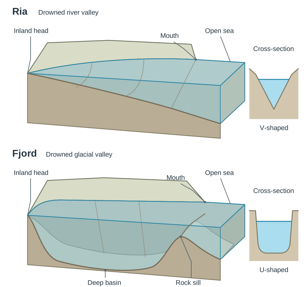
- Ria: A river valley drowned by rising sea level. It forms a long, funnel-shaped inlet that is deepest and widest at the seaward mouth and becomes steadily shallower and narrower inland. Examples include Bantry Bay and Kenmare Bay in south-west Ireland.
- Fjord: A deeply eroded, U-shaped glacial valley that has been flooded by rising post-glacial seas. Fjords are long, narrow inlets with steep, precipitous rock walls, extremely deep waters along their middle course, and a shallow submerged rock sill (threshold) near the mouth where the glacier thinned. A classic Irish example is Killary Harbour on the Galway–Mayo border.
Human Interaction: Coastal Management and Case Studies
Section 1.7 of the syllabus asks you to study one of three human-interaction options. The coastal option covers coastal defence works, recreational pressures, and conservation and management measures. Ireland has over 3,000 km of coastline, much of which is vulnerable to erosion and winter storm surges.
Coastal Defence Engineering
- Sea walls (hard engineering): Solid concrete walls built parallel to the shore. Many have a curved seaward face that deflects incoming wave energy back out to sea. While sea walls protect urban infrastructure, they are expensive and the deflected backwash can scour sand from the beach base.
- Rock armour / rip-rap (hard engineering): Large, angular granite or limestone boulders piled along the base of cliffs or in front of sea walls. The open spaces between boulders allow water to filter through, absorbing and dissipating wave energy.
- Groynes (hard engineering): Low barriers of wood, stone, or concrete constructed at right angles to the shoreline. They trap sediment carried by longshore drift, widening the beach on the updrift side. However, groynes cut off sediment supply to the coast further along, accelerating erosion downdrift.
- Beach nourishment (soft engineering): Sand or shingle dredged offshore is pumped onto an eroded beach to restore its natural width and absorb wave energy. This preserves natural scenery but requires repeated operations over time.
- Dune management (soft engineering): Planting marram grass, installing timber fences to trap sand, and laying boardwalks to direct foot traffic away from fragile dune plants.
Recreational Pressure and Conservation: Sand Dunes
Popular beaches draw thousands of visitors during summer, placing heavy pressure on coastal dune ecosystems:
- Intensive walking and trampling damage and kill marram grass, breaking the root network that binds the sand.
- Without vegetation cover, onshore winds blow loose sand away, creating bare depressions called blowouts.
- As blowouts deepen and merge, dunes lose their height and volume, destroying the natural coastal barrier that protects low-lying inland areas from marine flooding.
At Brittas Bay, County Wicklow, heavy recreational pressure severely degraded the dune system. Conservation and management measures introduced to protect the dunes include:
- Fencing off damaged areas to allow native vegetation to recover.
- Building wooden boardwalks so visitors can access the beach without trampling dune ridges.
- Replanting marram grass to stabilise bare sand.
- Installing information boards and granting legal protection as a Special Area of Conservation (SAC).
Case Study 1: Dublin Bay and Bull Island (Unintended Human Impact)
During the 18th and early 19th centuries, shifting sandbanks choked the mouth of the River Liffey, stranding merchant vessels entering Dublin Port. To solve this, the Great South Wall was completed in the late 1700s, followed by the North Bull Wall in the 1820s.
The two walls narrowed the entrance to Dublin Harbour, concentrating tidal currents and scouring the shipping channel deeper. However, the North Bull Wall disrupted natural sediment transport in Dublin Bay. Sand accumulated rapidly in the sheltered, low-energy waters behind the wall. Over decades, this built up an entirely new landform: Bull Island, which now stretches over 5 km in length. Colonised and anchored by marram grass, the island is now an internationally recognised nature reserve and UNESCO Biosphere Reserve.
Case Study 2: Coastal Protection at Lahinch, County Clare
Lahinch sits at the head of Liscannor Bay, fully exposed to destructive Atlantic waves. To protect its promenade, golf course, and beachfront businesses, a curved concrete sea wall was installed, fronted by rock armour boulders.
During severe winter storms in early 2014, including Storm Darwin, powerful storm surges smashed against the defences. The waves overtopped the sea wall, cracked promenade concrete, ripped away metal railings, and flooded surrounding car parks. Subsequent repairs strengthened the defences by expanding the rock armour barrier at the foot of the wall to break the hydraulic impact of incoming storm waves before they strike the concrete face.
Key terms
- Fetch
- The unbroken distance of open water over which the wind blows uninterrupted to generate waves.
- Swash
- The forward movement of water and sediment rushing up the beach face after a wave breaks.
- Backwash
- The flow of water and sediment dragged straight back down the beach slope toward the sea under gravity.
- Constructive Wave
- A low-frequency, flat wave whose swash is stronger than its backwash, leading to net sediment deposition.
- Destructive Wave
- A steep, high-frequency wave whose backwash is stronger than its swash, scouring sediment and causing erosion.
- Wave Refraction
- The bending of wave crests as they reach shallow water near an irregular coast, focusing energy on headlands and spreading it in bays.
- Hydraulic Action
- The mechanical erosive force exerted by the physical impact and weight of crashing waves against rock faces.
- Abrasion
- The scouring and wearing down of coastal rocks by sand, pebbles, and boulders thrown against them by breaking waves.
- Attrition
- The reduction in size and rounding of sediment particles as they collide with one another in turbulent surf.
- Longshore Drift
- The lateral transport of coastal sediment along a shore in a zigzag path caused by oblique swash and perpendicular backwash.
- Wave-Cut Platform
- A gently sloping rock surface exposed at low tide at the base of a retreating sea cliff, planed down by abrasion.
- Tombolo
- A depositional ridge of sand or shingle connecting an offshore island directly to the mainland.
- Baymouth Bar
- A continuous sand or shingle ridge growing completely across the mouth of a bay, sealing off a lagoon behind it.
- Marram Grass
- A tough, salt-tolerant plant (Ammophila arenaria) with deep, fibrous root networks that bind sand and stabilise coastal dunes.
- Blowout
- A saucer-shaped hollow scooped out of a sand dune by wind erosion after vegetation has been removed by trampling.
- Eustatic Change
- A worldwide rise or fall in sea level caused by changes in the volume of ocean water, such as the melting or growth of continental ice sheets.
- Isostatic Rebound
- The slow uplift of the earth's crust after the melting of heavy ice sheets that had depressed it during an ice age.
- Ria
- A long, funnel-shaped drowned river valley formed when post-glacial sea levels rose relative to the land, deepest and widest at its mouth.
- Fjord
- A deep, steep-sided, drowned glacial U-shaped valley with a shallow submerged rock sill at its mouth.
- Significant Relevant Point (SRP)
- A distinct, coherent statement of geographical fact, explanation, statistic, or named example used to award marks in Leaving Certificate Higher Level answers.
Check yourself
Explain briefly what is meant by wave refraction.
Wave refraction is the bending of waves as they approach an irregular coast; wave energy is concentrated on protruding headlands and spread out in sheltered bays.
What is the primary difference in energy and movement between constructive and destructive waves?
Constructive waves have a swash stronger than their backwash, depositing sediment. Destructive waves have a backwash stronger than their swash, scouring sediment and causing erosion.
Classify the following landforms as features of erosion or deposition: sea arch, sandspit, lagoon, wave-cut platform, tombolo, sea stack.
Erosion: sea arch, wave-cut platform, sea stack. Deposition: sandspit, lagoon, tombolo.
A coastline retreated 16.5 metres between 2008 and 2018. Calculate the average annual rate of coastal erosion.
16.5 m ÷ 10 years = 1.65 metres per year.
Name two coastal landforms associated with isostatic rise (emergence) and two associated with sea-level rise/submergence.
Emergence (rising land): raised beaches, raised sea cliffs, raised wave-cut platforms. Submergence (rising sea): rias, fjords.
How does human recreational pressure on beaches trigger dune blowouts?
Intensive walking and trampling kill marram grass, destroying the root systems that bind sand grains together. Strong winds then scoop out bare hollows (blowouts) in the loose sand.