

An aerial photograph is simply a photograph of the landscape taken from above, from an aircraft or a drone. Because it records one moment in time, it shows exactly what was on the ground on the day it was taken, including traffic, crops, and half-built houses. In Leaving Certificate Higher Level Geography, aerial photographs appear in two distinct ways: as Part One short questions testing photograph classification, grid references, camera direction, and physical landforms, and as stimulus material in longer multi-part questions exploring urban functions, traffic management, and land use. Developing competency in aerial photo interpretation requires mastering absolute and relative location, constructing half-scale sketch maps, cross-referencing photographic details with 1:50 000 Ordnance Survey (OS) maps, and understanding their integration within Geographic Information Systems (GIS) and the compulsory geographical investigation.
Types of Aerial Photographs and Camera Angles
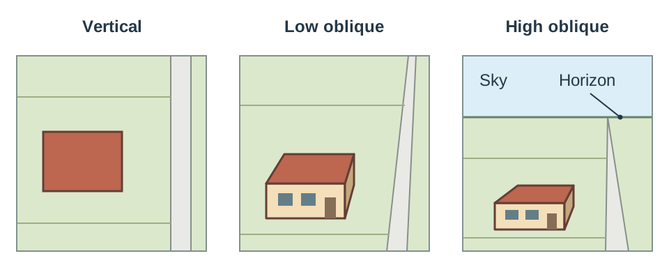
The angle of the camera decides what you see: point it straight down and the photograph looks like a map; tilt it and you see the sides of buildings and the shape of the land.
- Vertical Aerial Photographs: Taken with the camera pointing straight down at a angle to the ground. These produce a planimetric view, meaning features are shown in their map positions without perspective distortion. Distances and directions are reliable across the centre of the image, making vertical photographs suitable for mapping, measuring ground areas, and tracing field boundaries.
- Oblique Aerial Photographs: Captured with the camera tilted at an angle from an aircraft. This angled perspective displays the sides and heights of buildings, hills, and street layouts in three dimensions. Oblique photographs fall into two distinct classes based on whether the horizon appears in the frame:
- Low Oblique: The camera tilts towards the ground so that the horizon is not visible. This perspective highlights individual housing layouts, shopfronts, and fine architectural detail.
- High Oblique: The camera angle takes in both the ground and the horizon line with the sky. This wider view shows the broader topographical setting, mountain backdrops, and surrounding rural-urban fringes.
To classify an oblique photograph in an exam, check the top margin of the image. If the sky or horizon line appears, state that it is a high oblique; if the image shows only ground features right to the top edge, state that it is a low oblique.
Determining Camera Direction from OS Maps
Terminal examination questions regularly pair an oblique photograph of an Irish settlement with an extract from a 1:50 000 OS map. A standing question asks you to identify the direction in which the camera was pointing when the photograph was taken.
Step-by-Step Procedure
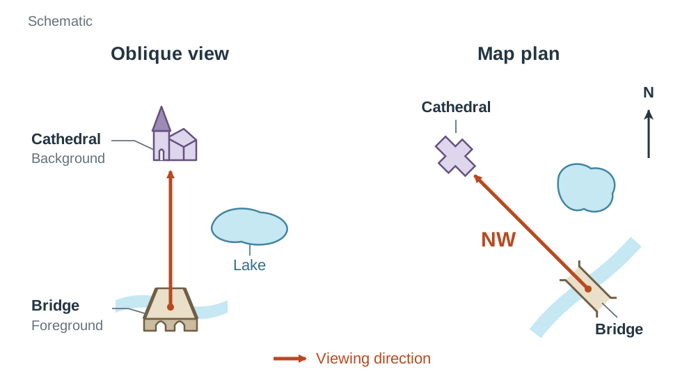
- Select a prominent, unmistakable landmark in the foreground of the photograph, such as a bridge, road junction, or church.
- Pick a second clear landmark in the background that sits directly in line with your foreground landmark.
- Locate both identical features on the accompanying 1:50 000 OS map.
- Draw a straight pencil line on the OS map running from the foreground feature towards the background feature.
- Read the compass direction that this line travels across the map. If the line points from the foreground bridge towards a background cathedral to the north-west, the camera pointed north-west.
A frequent error is reading the direction backwards from background to foreground. Remember that the camera lens looks from the front into the distance. To verify your answer, check a third feature: if a lake sits to the right of your line of sight on the photograph, it must also lie to the right of your pencil line on the map.
Grid References: Absolute and Relative Location
The Higher Level syllabus requires you to use both absolute location and relative location across maps and aerial imagery.
Absolute Location Using the Irish National Grid
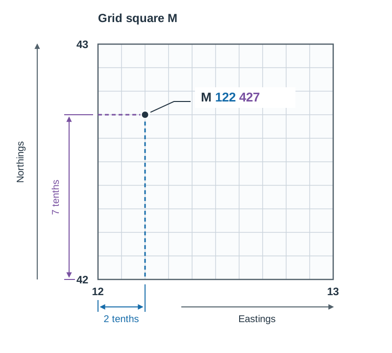
An aerial photograph alone carries no coordinates, so absolute location requires cross-referencing the photograph with the 1:50 000 OS map. Ordnance Survey maps of Ireland are covered by the Irish National Grid: 100 km squares each identified by a single letter (such as M for Galway, H for Cavan, or O for Dublin). Inside each letter square, grid lines form 1 km squares numbered along the bottom (eastings) and up the side (northings).
Always follow the rule: eastings before northings ('along the corridor, then up the stairs').
- Four-figure grid reference: Identifies a full 1 km square (used for lakes, hills, or large woods). Locate the easting line along the left edge of the square, then the northing line along the bottom edge. Write the grid letter followed by the two easting digits and the two northing digits (for example,
H 42 04). - Six-figure grid reference: Pinpoints an exact feature (such as a church, bridge, or school). First take the four-figure square. Imagine the square divided into ten equal units from west to east; estimate the tenths from the left-hand line to get the third easting digit. Next, estimate the tenths from the bottom northing line upwards to get the third northing digit. Write the grid letter, three easting digits, and three northing digits (for example,
M 122 427).
Relative Location on Photographs
On a vertical photograph, you can describe positions using compass directions: unless the paper indicates otherwise, take north to be at the top of the photograph. Describe locations as north-west, north, north-east, west, centre, east, south-west, south, or south-east.
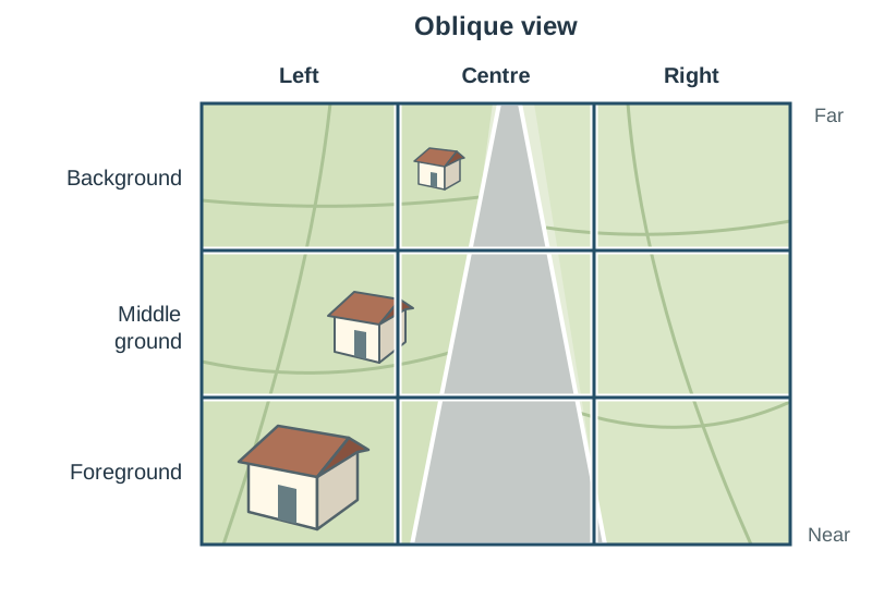
On an oblique photograph, you must not use compass directions unless a north arrow is explicitly printed on the image. Instead, use the nine-section grid. Think of a noughts-and-crosses grid laid over the photograph. The bottom row is the foreground (nearest the camera), the middle row is the middle ground, and the top row is the background (farthest away). Combine these rows with left, centre, and right columns to produce nine zones, such as left foreground or centre background.
Recognising Physical Landforms and Coastal Defences
Part One questions regularly present three or four aerial photographs of physical features, requiring you to identify the landform and match it to its forming process.
Landform Identification
- Coastal features: Cliffs appear as steep rock faces fronted by a wave-cut platform at low tide. Sea stacks show as isolated rock pillars standing offshore. A sand spit appears as a long finger of deposited sand extending out from the coast with a hooked end. A tombolo is a narrow sand ridge linking an offshore island to the mainland. A lagoon is a body of shallow, calm water trapped behind a spit or barrier beach. Sand dunes appear as irregular sandy ridges behind a beach, anchored by marram grass.
- Coastal defences: Groynes appear as low timber or rock barriers built out into the sea at right angles to the shoreline to trap sand moved by longshore drift. Sea walls, rip-rap (rock armour), and wire-mesh gabions line the base of retreating cliffs.
- Glacial features: Corries appear as steep-sided, armchair-shaped hollows high on mountain sides, often holding a small tarn lake. Arêtes are razor-sharp rocky ridges between two corries. Striations appear as parallel scratches gouged across exposed bedrock. A moraine shows as an unsorted, hummocky ridge of boulder clay, while drumlins appear as smooth, egg-shaped hills in swarms.
- Karst and weathering features: A limestone pavement appears as a bare, grey expanse of rock divided into blocks (clints) separated by deep fissures (grykes). A scree slope shows as a fan-shaped accumulation of loose angular rock fragments resting at the foot of a cliff.
Matching Features to Geomorphic Processes
- Weathering: The breakdown of rock in situ without movement (such as carbonation forming limestone pavements, or freeze-thaw creating scree slopes).
- Erosion: The wearing away and active removal of rock by water, ice, or wind (such as glacial abrasion producing striations, or wave hydraulic action carving cliffs).
- Deposition: The dropping of transported sediment when a moving agent loses velocity (such as moraines deposited by melting ice, or spits and tombolos built by waves and longshore drift).
Urban Functions, Settlement Sites, and Land Use
Settlement questions ask candidates to identify the functions of a town or explain why it developed at that specific location, using photographic evidence.
Functions of the Town
When answering, state the function, describe the visible photographic proof, and specify its position:
- Commercial and retail: Continuous shopfronts, display awnings, and pedestrian crowds in the Central Business District (CBD) (for example, in the centre foreground).
- Ecclesiastical: A church with a prominent spire or square tower, adjoining graveyard, and parochial hall.
- Residential: Older, narrow terraced houses without front driveways near the core; modern semi-detached housing estates with driveways and cul-de-sacs in the middle ground; detached bungalows on the outer fringe.
- Industrial: Large, low-profile, flat-roofed rectangular warehouses, outdoor storage yards, and heavy goods vehicles (HGVs) parked in loading bays near peripheral roads.
- Educational: Large campus buildings arranged in wings, bordered by marked grass sports pitches and tarmac basketball courts.
- Administrative and civic: Town halls, courthouses, or Garda stations occupying large premises on primary central streets.
- Transport hub: Major road junctions converging on an old bridge, accompanied by railway stations, sidings, or bus depots.
- Tourism and recreation: Golf course fairways, public parks, hotels, or marinas.
Original Site and Situation
- Bridging point: The narrowest river crossing point where early routes converged to trade.
- Defensive site: Elevated ground, a meander loop, or a coastal promontory, often marked by a ruined stone castle or fragments of ancient town walls.
- Dry point: Slightly elevated ground standing safely above a seasonal river floodplain or wetland.
- Route focus: A natural valley confluence or mountain pass where historic trade routes intersected.
Shadows: Reading Time of Day and Season
Because Ireland lies in the northern hemisphere, the sun never sits directly overhead. It rises in the east, reaches its highest southern elevation at midday, and sets in the west. Cast shadows always fall in the direction opposite to the sun.
Estimating Time of Day
- Shadows cast towards the west indicate that the sun is in the east: morning.
- Shadows pointing north and appearing relatively short indicate that the sun is due south and at its daily peak: around midday.
- Shadows cast towards the east indicate that the sun is in the west: afternoon or evening.
Determining Season of the Year
- Summer: Indicated by short shadows, deciduous trees in full leaf canopy, cut fields showing golden silage or round hay bales, and ripening cereal crops.
- Winter or early spring: Indicated by long cast shadows due to low sun angles, completely bare deciduous trees, ploughed bare fields, waterlogged ground, or smoke rising straight from domestic chimneys.
When writing an exam answer, state your conclusion clearly before citing the evidence: 'The photograph was taken in summer because deciduous trees in the centre foreground are in full leaf and fields in the right background contain harvested silage bales.' If the photograph was taken under overcast skies with diffuse lighting, shadows may be absent; in that case, rely entirely on vegetation and farming clues.
Constructing an Accurate Half-Scale Sketch Map
Examiners regularly instruct candidates to draw a sketch map of an aerial photograph to half-scale. The standard command reads: 'Draw a sketch map of the aerial photograph and on it mark and name...' Read this carefully as two separate tasks.
- Mark: Position each requested feature inside your frame in its correct relative location. Placing a feature in the wrong third of the frame loses placement credit.
- Name: Clearly label the feature itself or provide a tidy legend/key. Drawing a feature without naming it, or naming a symbol in the key without showing it on the map, gains no marks.
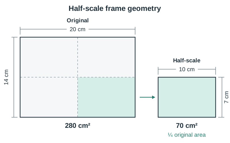
Drawing Method
- Measure the height and width of the printed photograph in centimetres using a ruler (for example, ).
- Divide both linear dimensions by 2. A photograph gives a half-scale frame of . Notice that halving both dimensions reduces the surface area to one quarter of the original ( compared with ).
- Rule this rectangular frame neatly on your answer paper using a pencil. A frame drawn roughly in correct proportion gives you the necessary boundary to position landmarks reliably. If the question explicitly specifies dimensions, always follow the question; otherwise, half-scale is standard practice.
- Lightly sketch a three-by-three reference grid across your drawn frame. This grid guides feature placement across the nine quadrants.
- Draw only the specific features asked for in the examination prompt. Outline general land-use zones rather than sketching individual buildings.
- Keep linear features (roads, railway lines, rivers) slender and proportional. Drawing roads as broad bands distorts adjacent zones.
- Provide a clear title and an explanatory key. Add a north arrow only if the source photograph or map clearly displays one; leave it off an oblique photograph.
Comparing Aerial Photographs with OS Maps and Satellite Imagery
Exam questions often explore the contrasting strengths and limitations of aerial photographs compared to OS maps.
| Attribute | Aerial Photograph | Ordnance Survey Map (1:50 000) |
|---|---|---|
| Viewpoint | Real bird's-eye view (oblique or vertical) | Planimetric horizontal projection |
| Representation | Shows true appearance (rooflines, traffic, crops) | Standardised cartographic symbols and colours |
| Currency | Captures a precise, transient instant in time | Updated intermittently; reflects permanent structures |
| Scale & Measurements | Distorts with perspective on obliques; no grid | Constant ratio (); 1 km grid squares |
| Relief Data | Inferred from shadows, cliff faces, and slopes | Contours at 10 m intervals and spot heights |
Aerial Photograph or Satellite Image?
- Aerial photographs are captured from aircraft or drones at altitudes between a few hundred and a few thousand metres. They cover localized areas (a town, a beach, a bay) in sharp detail, allowing you to identify individual cars, houses, and field gates.
- Satellite images are captured by digital sensors mounted on spacecraft orbiting hundreds of kilometres above Earth. They cover massive regional landscapes, entire drainage basins, or national boundaries. They often employ false colour (where healthy vegetation appears bright red or vibrant green) to track regional environmental changes.
GIS and Investigation Applications
A Geographic Information System (GIS) is a software tool used to store, manipulate, layer, and display spatial data. Higher Level students must know how aerial photographs are combined with other datasets to investigate geographic problems.
Combined GIS Studies
- Urban sprawl: Superimposing historical and modern aerial photographs over vector base maps and census data enables planners to calculate the rate at which outward residential growth converts agricultural land into built-up suburbs.
- Archaeological monitoring: In warm, dry weather, differential moisture retention in soils reveals buried ditch lines and ancient stone foundations as crop marks. Overlaying oblique photographs with the Record of Monuments and Places (RMP) protects hidden heritage sites from being destroyed during infrastructural works.
- Changing agricultural land use: Pairing satellite images with agricultural census statistics reveals shifts between pasture and tillage across river basins.
- Forestry development: Vertical aerial photographs combined with digital elevation models and felling records monitor coniferous plantation growth and tree clearance in upland catchments.
Role in the Geographical Investigation
In Core Unit 3, primary and secondary data sources must be incorporated in a ratio of approximately 60% primary to 40% secondary. An existing aerial photograph obtained from a planning office, library, or website is a secondary source because someone else gathered it. Photographs that you take yourself while standing in the field, alongside your own river, coastal, or traffic measurements, represent primary sources.
Key terms
- Planimetric
- A map-like horizontal representation of the landscape in which distances and directions are geometrically accurate across the image plane.
- Vertical Aerial Photograph
- A photograph taken from directly overhead with the camera pointed straight down at a 90-degree angle to the surface of the Earth.
- Low Oblique Photograph
- An aerial photograph taken from an angle where ground features and building facades are visible, but the camera angle excludes the horizon.
- High Oblique Photograph
- An aerial photograph captured at an inclined angle that includes the horizon line and sky within the upper section of the image.
- Nine-Section Grid
- A standardised system used to locate features on oblique aerial photographs by dividing the image into foreground, middle ground, and background across left, centre, and right columns.
- Eastings
- Vertical grid lines on an Ordnance Survey map numbered sequentially from west to east along the horizontal axis.
- Northings
- Horizontal grid lines on an Ordnance Survey map numbered sequentially from south to north along the vertical axis.
- Six-Figure Grid Reference
- A precise geographical coordinate comprising the National Grid letter followed by three easting digits and three northing digits, pinpointing an exact location to within 100 metres.
- Central Business District (CBD)
- The commercial, financial, and civic heart of an urban settlement, characterised by high building density, retail premises, and heavy pedestrian traffic.
- Longshore Drift
- The zig-zag movement of sediment along a coastline caused by waves breaking obliquely up the beach in the swash and returning directly perpendicular in the backwash.
- Groynes
- Low timber, concrete, or stone coastal defence barriers constructed at right angles to the shoreline to trap sand transported by longshore drift.
- Crop Marks
- Visible patterns of differential crop growth or soil parching seen from the air, highlighting buried archaeological stone walls or ancient ditches.
- Geographic Information System (GIS)
- A computer-based system designed to capture, store, analyse, manage, and display layers of spatially referenced geographical data.
Check yourself
What is the key visual feature that distinguishes a high oblique photograph from a low oblique photograph?
A high oblique photograph shows the horizon line and sky at the top of the frame, whereas a low oblique photograph tilts down so that the horizon is excluded.
A church on an OS map extract lies in the 1 km square with easting 12 and northing 42, approximately two tenths across and seven tenths up within the M grid square. What is its six-figure grid reference?
M 122 427 (Letter M, followed by easting 12 plus 2 tenths, then northing 42 plus 7 tenths).
If an original aerial photograph measures 18 cm by 12 cm, what are the dimensions and relative area of a half-scale sketch map frame?
The half-scale frame measures 9 cm by 6 cm, which covers one quarter (25%) of the total surface area of the original photograph.
If buildings cast long shadows pointing towards the north-west on an Irish aerial photograph, what is the approximate time of day and season?
It is morning: the shadows point north-west, so the sun is in the south-east. The long shadows show the sun is low in the sky, indicating winter or early spring.
Match these three features to their geomorphic process: limestone pavement, moraine, sea cliff.
Limestone pavement is formed by weathering (carbonation); moraine is formed by glacial deposition; sea cliff is formed by coastal erosion (hydraulic action and abrasion).
Why should you never place a north arrow on a sketch map drawn from an oblique aerial photograph?
Because perspective distortion causes compass directions to vary across an oblique image, so a single north arrow is cartographically inaccurate unless explicitly printed on the source photograph.