

This note covers the tectonic, volcanic, and seismic part of Core Unit 1 – the tectonic cycle (1.1) and the volcanic, plutonic, and faulting landforms of 1.3. The rock cycle, surface processes, and isostasy are covered in separate notes. It details the internal structure of the Earth, the development of plate tectonic theory, boundary mechanics, magma chemistry, intrusive and extrusive landforms, structural faulting, seismic wave physics, and hazard forecasting. It also evaluates contrasting earthquake and volcanic impacts through national and international case studies, including the Antrim-Derry Plateau, the Leinster Batholith, Iceland, Haiti, and Japan.
Internal Structure of the Earth and the Theory of Plate Tectonics
The Layers of the Earth
The Earth consists of concentric layers that increase in temperature, density, and pressure towards the centre:
- Crust: The thin, solid outer shell. It comes in two distinct varieties:
- Continental crust (sial): Composed mainly of granitic rocks rich in silica and aluminium. It averages 35 to 70 km in thickness beneath mountain ranges and is relatively buoyant with a low density of about 2.7 g/cm³.
- Oceanic crust (sima): Composed mainly of basaltic rocks rich in silica and magnesium. It is only 5 to 10 km thick and is denser (about 3.0 g/cm³). Because of this density contrast, oceanic crust always subducts beneath continental crust during collisions.
- The boundary between the crust and the mantle is marked by a sharp change in rock density known as the Mohorovičić discontinuity (Moho).
- Mantle: Extends to a depth of approximately 2,900 km and consists of hot, silicate rock. The rigid uppermost section of the mantle combines with the crust to form the lithosphere (the tectonic plates). Directly beneath lies the semi-molten, ductile asthenosphere, where slow convection currents circulate and drive plate motion.
- Outer core: A layer roughly 2,200 km thick composed of molten (liquid) iron and nickel. Fluid movements within the outer core generate the Earth's geomagnetic field.
- Inner core: A solid metallic sphere with a radius of about 1,200 km, composed of solid iron and nickel reaching temperatures up to 5,500 °C. Immense gravitational pressure prevents it from melting despite the extreme heat.
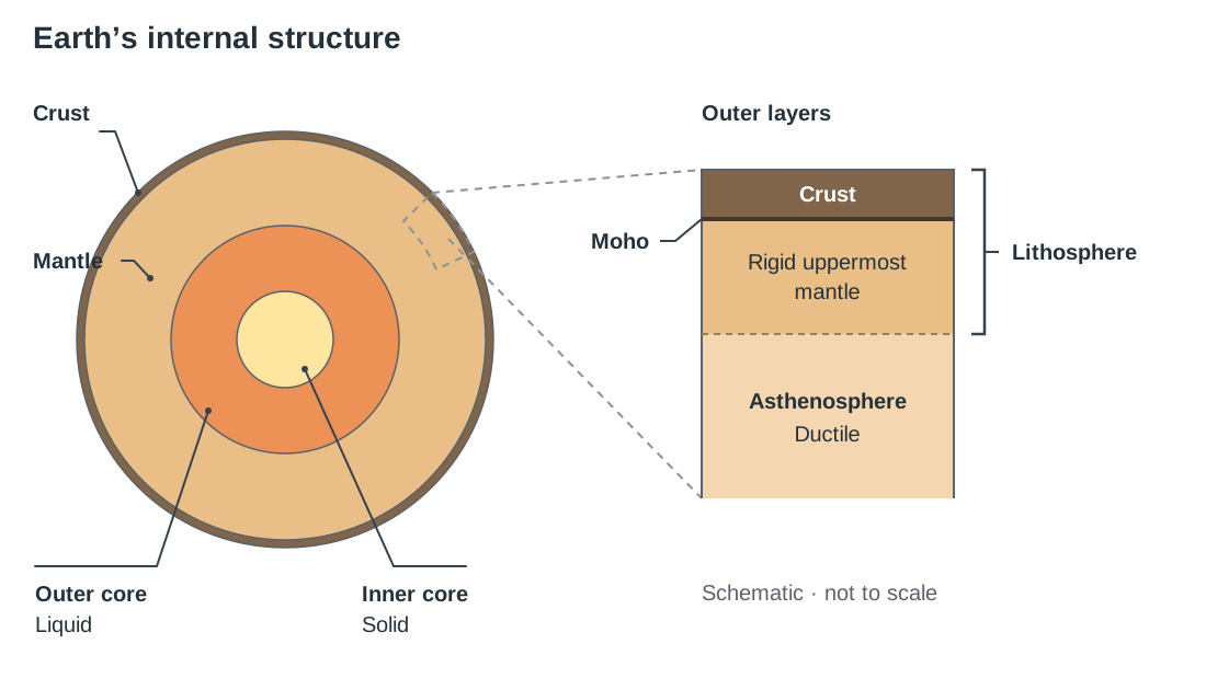
Scientists know the outer core is liquid because transverse seismic secondary waves (S-waves) cannot travel through liquids. An earthquake produces a broad S-wave shadow zone on the opposite side of the planet, confirming that seismic shear waves are blocked by a liquid outer core layer.
Where the Theory Came From
In 1912, the German meteorologist Alfred Wegener proposed the theory of continental drift. He suggested that roughly 250 million years ago, all landmasses formed a single supercontinent called Pangaea, which later split into Laurasia in the north and Gondwanaland in the south before drifting into their modern configurations. Wegener provided four primary lines of evidence:
- Jigsaw fit: The complementary continental coastlines, most visibly seen between the east coast of South America and the west coast of Africa.
- Fossil correlation: Identical fossil remains of the freshwater reptile Mesosaurus (incapable of swimming across an ocean) found exclusively in south-eastern South America and southern Africa; and fossils of the seed-fern Glossopteris spanning South America, Africa, India, and Australia.
- Matching mountain belts: The Caledonian fold mountains across Ireland and Scotland align in rock type, age, and structural trend with the Appalachian Mountains of Newfoundland and eastern North America.
- Palaeoclimatic evidence: Ancient glacial till deposits and striations from the Carboniferous period preserved in tropical and arid regions of modern-day India, Australia, and equatorial Africa.
Wegener's continental drift was rejected by the geological community for decades because he could not prove the mechanical force capable of plowing solid continents across ocean basins.
In 1962, the American geologist Harry Hess solved this puzzle with the concept of sea-floor spreading. Sonar surveys of ocean basins revealed an underwater volcanic mountain chain, the Mid-Atlantic Ridge, where rising basalt forms new oceanic crust that shoves older crust outwards on either side:
- Age of the oceanic crust: Basalt is youngest at the mid-ocean ridge axis and becomes progressively older with distance from the ridge towards continental margins. No ocean-floor rock exceeds 200 million years in age, whereas continental shield rocks exceed 3,800 million years.
- Palaeomagnetism: As basaltic lava cools through the Curie point, iron-bearing magnetite minerals align with the Earth's magnetic orientation. Because the Earth's geomagnetic field undergoes periodic polarity reversals, the seafloor preserves symmetrical bands of alternating normal and reversed magnetic polarity parallel to the ridge crest. This symmetrical magnetic striping confirmed sea-floor spreading.
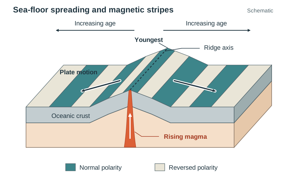
Uniting Wegener's drift with Hess's sea-floor spreading established the modern plate tectonics model: the rigid lithosphere is fractured into mobile tectonic plates that drift over the ductile asthenosphere, propelled by mantle convection cells, slab pull at subduction trenches, and gravitational ridge push at mid-ocean spreading centres.
Plate Boundaries, Global Distribution, and Ireland's Tectonic History
Plate Boundary Mechanics
Tectonic activity is concentrated along plate boundaries where crustal plates interact:
- Destructive (convergent) boundaries: Plates move towards one another under compressional stress.
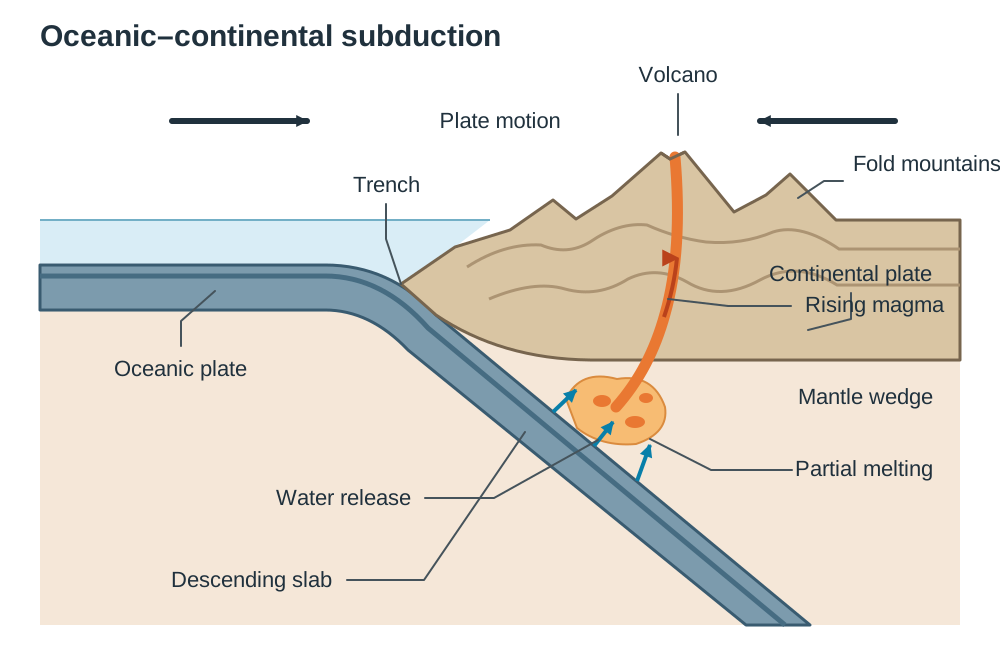
- Oceanic-continental: The denser oceanic plate bends down into an ocean trench and descends beneath the continental plate into a subduction zone. As the slab sinks, it dehydrates, releasing volatile water into the hot mantle wedge above. This water lowers the melting point of the surrounding rock (partial melting), creating buoyant magma that ascends to construct volcanic arcs and fold mountains (e.g., the Nazca Plate subducting beneath the South American Plate to form the Andes).
- Oceanic-oceanic: The older, colder, and denser oceanic plate subducts beneath the younger plate, generating deep trenches and chains of volcanic islands termed volcanic island arcs (e.g., the Pacific Plate subducting beneath the Eurasian and North American plates to build Japan and the Aleutian Islands).
- Continental-continental: Two low-density continental slabs collide. Neither plate subducts because both are buoyant; instead, the crust crumples and thickens to form massive fold mountains, accompanied by shallow, severe earthquakes but no volcanism (e.g., the Indo-Australian Plate colliding with the Eurasian Plate to raise the Himalayas).
- Diagram check: To sketch a subduction zone, draw facing plate arrows, a down-bending oceanic slab entering an oceanic trench, magma bubbles ascending above the descending slab, and a volcano atop fold mountains.
- Constructive (divergent) boundaries: Plates pull apart under tensional stress. As plates separate along mid-ocean ridges, confining pressure on the asthenosphere falls, causing decompression melting of basaltic mantle. Fluid basic magma upwells to generate new oceanic floor (e.g., the Mid-Atlantic Ridge). On continents, tension stretches and thins the crust, creating rift valleys with active volcanism (e.g., the East African Rift System).
- Diagram check: Draw diverging arrows, an active rift valley along the ridge axis, upwelling mantle magma beneath, and symmetrical seafloor layers.
- Conservative (transform) boundaries: Plates slide laterally past each other along vertical strike-slip faults. Crust is neither constructed nor destroyed. Friction binds rock edges until elastic stress overcomes rock strength, producing shallow-focus earthquakes without volcanic activity (e.g., the San Andreas Fault in California between the Pacific and North American plates).
- Hotspots: Fixed plumes of unusually hot mantle rock that melt their way up through the plate moving above them. As the lithospheric plate glides overhead, an age-progressive chain of volcanic islands develops (e.g., Hawaii, Yellowstone, and Réunion).
The Global Distribution of Activity
Volcanoes and earthquakes are clustered along narrow, distinct zones:
- The Pacific Ring of Fire: A horseshoe-shaped belt spanning 40,000 km around the margins of the Pacific Ocean basin, running from New Zealand through Indonesia, the Philippines, Japan, the Aleutian Islands, Alaska, and down the west coasts of North and South America. Subduction along the edges of the Pacific, Nazca, Cocos, and Philippine plates causes this zone to contain approximately 75% of the world's active volcanoes and over 80% of all recorded earthquakes.
- The Mid-Ocean Ridge Belt: Extends along constructive marine boundaries (the Mid-Atlantic Ridge, East Pacific Rise). Volcanism here is frequent but effusive, and earthquakes are shallow and moderate.
- The Alpine-Himalayan Belt: Runs east-west from the Mediterranean basin through Turkey, Iran, northern India, and into south-east Asia, formed as the African and Indo-Australian plates compress into the Eurasian Plate. Characterised by destructive shallow earthquakes and limited volcanism (Etna and Vesuvius in Italy).
Major lithospheric plates to identify on stimulus maps include the Pacific, North American, South American, Eurasian, African, Indo-Australian, Antarctic, Nazca, Caribbean, Philippine, Cocos, and Arabian plates.
Ireland's Position in Relation to Plate Boundaries
Present day: Ireland sits in an intraplate position on the stable interior of the Eurasian Plate, roughly 2,000 km east of the Mid-Atlantic Ridge. Lacking active tectonic boundaries, Ireland experiences no active volcanism and only infrequent, low-energy seismic tremors (typically under magnitude 3.0).
Past geological periods: Ireland's structural geology was formed by past boundary collisions and rifting events:
- Caledonian Orogeny (~400 million years ago): Northern Ireland and southern Ireland were originally on separate continental landmasses (Laurentia and Avalonia) separated by the Iapetus Ocean. As these plates collided, the ocean closed completely along a collision line known as the Iapetus Suture, which runs from the Shannon Estuary to Clogherhead in County Louth. The immense collision folded sedimentary rocks into a south-west to north-east trend and intruded granitic magma to form the Leinster Batholith and the Donegal granite complexes.
- Armorican (Variscan) Orogeny (~300 million years ago): A continental collision to the south folded Munster into an east-west ridge-and-valley province (sandstone anticlinal ridges and limestone synclinal valleys) and pushed older strata over younger rock along the Armorican thrust front.
- North Atlantic Opening (~60 million years ago): Tensional rifting pulled the Eurasian and North American plates apart. Fissure eruptions extruded huge volumes of fluid basic lava, creating the stepped basalt landscape of the Antrim-Derry Plateau.
Magma Chemistry, Volcanic Structures, and Eruptions
Magma Chemistry and Eruption Styles
The physical behaviour of molten rock is governed by silica content (), temperature, and dissolved volatile gases. Underground molten rock is magma; upon erupting on the surface, it is termed lava.
| Characteristic | Basic (Basaltic) Magma | Acidic (Andesitic / Rhyolitic) Magma |
|---|---|---|
| Silica Content | Low (approx. 50% ) | High (up to 70% ) |
| Temperature | High (1,100 °C to 1,200 °C) | Lower (800 °C to 900 °C) |
| Viscosity | Low (fluid, runny) | High (thick, sticky, pasty) |
| Gas Behaviour | Dissolved gases vent gently | Gases trapped under pressure until explosive release |
| Eruption Style | Effusive, gentle lava fountaining and flows | Violent, explosive with pyroclastic clouds and ash |
| Tectonic Setting | Constructive margins and oceanic hotspots | Destructive subduction zones and continental margins |
| Typical Landforms | Shield volcanoes, lava plateaux | Composite volcanoes (stratovolcanoes), calderas |
| Examples | Mauna Loa (Hawaii), Antrim basalts | Mount Fuji (Japan), Mount Pinatubo (Philippines) |
Anatomy of a Volcano and Pyroclastic Materials
Stimulus diagrams require students to identify core volcanic structures:
- Magma chamber: The subsurface reservoir of molten rock beneath the volcano.
- Main vent (conduit): The central vertical pipe through which magma travels to the surface.
- Crater: The bowl-shaped depression at the volcanic summit surrounding the vent opening.
- Composite cone: The conical mountain built from alternating strata of hardened lava and tephra.
- Parasitic (secondary) cone: A flank cone formed when secondary conduits fracture outward from the main pipe.
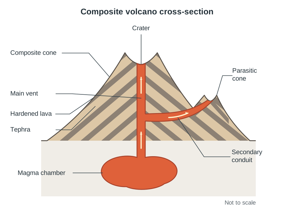
Pyroclastic material (tephra) comprises all solid rock fragments violently blasted into the atmosphere by expanding gases during an explosive eruption. They are classified by grain size:
- Volcanic ash: Fine particles of pulverised rock and volcanic glass measuring under 2 mm in diameter.
- Lapilli: Cinder fragments ranging from 2 mm to 64 mm (pea- to walnut-sized).
- Volcanic bombs and blocks: Solid fragments exceeding 64 mm in diameter; volcanic bombs are incandescent blobs of lava that solidify into streamlined, aerodynamically shaped projectiles in flight.
- Pumice and scoria: Highly vesicular, frothy volcanic rocks formed by gas expansion; pumice has such high porosity and low bulk density that it floats on water.
Volcanic Life Cycle
- Active: Currently erupting or displaying historical evidence of activity with an active magma supply (e.g., Mount Etna in Sicily; Mount Vesuvius, which last erupted in 1944).
- Dormant: Inactive for centuries but retaining an intact magma reservoir and potential to erupt (e.g., Mount St Helens prior to 1980; Mount Kilimanjaro in Tanzania).
- Extinct: No eruptions in recorded history and completely disconnected from an active magma source. The magma chamber has solidified, and plate motion has shifted the volcano away from tectonic melting zones (e.g., Slemish, County Antrim, which is the exposed dolerite volcanic plug of a Palaeogene volcano).
Predicting Volcanic Eruptions: Volcanologists monitor active and dormant volcanoes using several warning signs: (1) rising seismic activity – swarms of small earthquakes recorded by seismometers placed within about 20 km of the vent as magma forces its way up; (2) ground deformation – tiltmeters, GPS, and satellite radar detecting the swelling of the cone; (3) changes in gas emissions – a sharp rise in sulphur dioxide escaping from the vent showing fresh magma is near the surface; and (4) eruption history from past records. At Mount Pinatubo in 1991, monitoring allowed authorities to evacuate tens of thousands of people (about 58,000 within a 30 km zone) before the eruption, saving many lives.
Case Study: Eyjafjallajökull Eruption, Iceland (April 2010)
- Tectonic setting: Southern Iceland sits astride the constructive Mid-Atlantic Ridge (where the Eurasian and North American plates diverge at 2 cm/year) and over a buoyant mantle hotspot.
- Cause and eruption dynamics: Tensional rifting allowed basic basaltic magma to upwell. The eruption became explosively violent because the fissure vent opened directly beneath an ice cap. Meltwater poured into the volcanic crater, flashing into steam and quenching the hot magma into microscopic, jagged glass shards. This phreatomagmatic explosion produced an ash plume reaching 9 km into the atmosphere.
- Local impacts: Approximately 800 local farming residents were evacuated due to jökulhlaups (glacial outburst floods) that washed away sections of Iceland's Route 1 ring road. Thick ash smothered pastures, and high fluoride concentrations contaminated water supplies, poisoning grazing livestock.
- International economic impacts: Volcanic ash melts inside modern jet turbines at 1,100 °C, coating turbine blades in molten glass and risking engine failure. Consequently, aviation authorities closed European airspace for six days. Around 100,000 commercial flights were grounded, stranding over 10 million passengers worldwide and costing the airline industry roughly €1.3 billion. Irish exports reliant on air freight were disrupted, and Kenyan horticultural producers suffered major financial losses as perishable cut flowers rotted awaiting transport.
- Human opportunities: Volcanic activity along the rift provides Iceland with abundant geothermal energy (heating 87% of buildings and generating 30% of its electricity) alongside a profitable volcano-tourism sector.
Extrusive and Intrusive Igneous Landforms
Extrusive Volcanic Landforms
Extrusive landforms develop on the Earth's surface when lava cools rapidly in contact with the atmosphere or water, creating fine-grained igneous rocks with small mineral crystals (e.g., basalt):
- Shield Volcanoes: Enormous, broad volcanic domes with gentle slope angles (typically 2° to 10°), built of thousands of successive flows of fluid basic lava. Because basaltic lava has low viscosity, it travels long distances before solidifying. Mauna Loa in Hawaii rises over 4,100 m above sea level, with a submarine base spanning over 100 km across the ocean floor.
- Composite Cones (Stratovolcanoes): Steep, symmetrical volcanic cones composed of alternating strata of viscous andesitic or rhyolitic lava flows and explosive pyroclastic tephra (ash, lapilli). Built over subduction zones, their viscous lava cools close to the vent, raising steep slopes. Examples include Mount Fuji in Japan and Mount Pinatubo in the Philippines.
- Cinder Cones: Small, steep-sided cones, usually under about 400 m in height, built entirely from tephra blasted out around a single vent. Parícutin in Mexico grew from a crack in a farmer's maize field in 1943 to about 336 m in its first year, eventually reaching roughly 420 m before activity ceased in 1952.
- Lava Plateaux: Flat, expansive tablelands constructed from horizontal sheets of basalt. Low-viscosity basic lava upwells quietly through elongated fractures in the crust during fissure eruptions. The Antrim-Derry Plateau formed 60 million years ago when the opening North Atlantic split the crust. Fissure flows built a basaltic lava pile several hundred metres thick – exceeding 800 m in the Lough Neagh basin. During cooling, uniform thermal contraction fractured the rock into hexagonal basalt columns, forming the Giant's Causeway.
- Calderas: Vast circular depressions produced when a catastrophic volcanic eruption rapidly drains the underlying magma reservoir. Deprived of structural support, the roof of the volcano collapses downward into the empty chamber. Examples include Crater Lake in Oregon and the caldera of Santorini in Greece.
Intrusive Plutonic Landforms
Intrusive landforms form when magma forces its way into the Earth's crust and solidifies deep underground. Insulated by overlying country rock, the magma cools slowly over millions of years, forming coarse-grained crystalline igneous rock with visible mineral crystals, such as granite. Over geological timescales, denudation strips away the softer overlying sedimentary cover to expose these features at the surface.
| Plutonic Feature | Geometry & Concordance | Description and Named Examples |
|---|---|---|
| Batholith | Discordant, massive (>100 km²) | Deep magma chamber that solidifies in the roots of fold mountain ranges. Example: The Leinster Batholith, extending across 1,500 km² through Dublin, Wicklow, and Carlow. Formed during the Caledonian collision, its heat created a protective metamorphic aureole of mica schist capping the granite at Lugnaquilla. |
| Sill | Concordant, horizontal sheet | Formed when magma injects horizontally between and parallel to existing sedimentary bedding planes. Examples: Fair Head, Co. Antrim, and the Portrush Sill, Co. Antrim. |
| Dyke | Discordant, vertical wall | Magma intrudes along vertical joints and fractures, cutting perpendicularly across rock strata. Example: The Mourne dyke swarm, radiating from the Mourne Mountains and exposed as resistant wall-like ribs on the Co. Down coast near Annalong and Kilkeel; internationally, the Great Dyke of Zimbabwe. |
| Laccolith | Concordant, mushroom dome | Viscous magma pools between strata, forcing overlying rock layers to arch upwards into a dome with a flat floor. Example: Pine Valley, Utah. |
| Lopolith | Concordant, saucer basin | A massive sheet of magma whose weight causes underlying rock strata to sag downward into a basin shape. Example: Bushveld Complex, South Africa. |
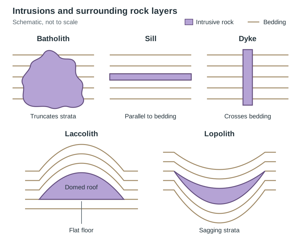
Structures of Deformation: Faulting and Associated Landforms
Tectonic stress fractures and displaces rock along plane surfaces called faults. Faulting is categorised according to the direction of stress and relative displacement:
Normal Faults (Tensional Stress)
Tensional forces pull the crust apart, causing crustal extension. The fracture plane is angled, and the block of rock overlying the fault plane (the hanging wall) slips downward relative to the underlying block (the footwall).
- Graben (Rift Valley): A downfaulted block of crust dropped between two parallel, outward-dipping normal faults. Prominent examples include the East African Rift Valley and the Rhine Rift Valley between France and Germany.
- Horst (Fault-Block Mountain): An upstanding block of crust left standing high as adjacent blocks slip downward along bounding normal faults. Examples include the Vosges Mountains in France and the Black Forest in Germany.
Reverse and Thrust Faults (Compressional Stress)
Compressional forces squeeze and shorten the crust. The hanging wall is pushed upward relative to the footwall. Where the fracture angle is steep (>45°), it is a reverse fault. Where the fracture angle is low (<45°), it is termed a thrust fault, common in collision zones where older basement rock is shoved over younger sedimentary strata:
- Irish Example: The Armorican thrust front across Munster. Compressional stresses from the south roughly 300 million years ago forced older Devonian sandstone up and over younger Carboniferous limestone along low-angle thrust planes. This deformation shaped the ridge-and-valley province of Cork and Kerry, forming resistant Old Red Sandstone ridges (e.g., the MacGillycuddy's Reeks) and downfolded limestone valleys (e.g., the Blackwater valley).
Strike-Slip (Tear) Faults (Shear Stress)
Shear forces slide crustal blocks past one another horizontally along a vertical fault plane with minimal vertical movement:
- Irish Example: The Leannan Fault in County Donegal. Running south-west from Lough Swilly through Kilmacrennan, this major strike-slip tear fault is the Irish continuation of Scotland's Great Glen Fault, active during the Caledonian orogeny. Rocks on opposing sides have been offset laterally by tens of kilometres; physical shattering along the fault zone allowed weathering to carve out a linear structural valley.
- International Example: The San Andreas Fault in California, a right-lateral transform fault extending over 800 km through the state, along which the Pacific Plate has slid horizontally past the North American Plate by hundreds of kilometres.
Earthquake Mechanics, Seismic Waves, Measurement, and Forecasting
Earthquake Mechanics
An earthquake is the sudden release of accumulated strain energy in the lithosphere. The mechanism is explained by the elastic rebound theory: as tectonic plates move, friction locks the fault plane. Tectonic stress bends and distorts the rock elastically – much like bending a wooden ruler. Strain builds until it exceeds the shear strength of the rock. The fault suddenly slips, and the distorted rock snaps back into place, releasing stored energy as seismic shockwaves radiating in all directions.
- Focus (hypocentre): The underground point along a fault plane where rupture begins and seismic energy is released. Shallow-focus earthquakes (0 to 70 km deep) cause the greatest destruction because seismic waves travel shorter distances to the surface and lose little energy. Intermediate (70 to 300 km) and deep-focus (300 to 700 km) events occur along descending oceanic slabs in subduction zones.
- Epicentre: The point on the Earth's surface positioned directly above the focus, experiencing the most intense shaking.
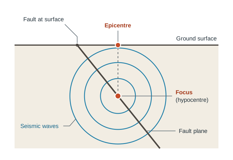
Seismic Waves
Earthquake energy propagates through the Earth as seismic waves:
- Primary Waves (P-waves): Longitudinal compressional body waves that compress and expand rock particles parallel to the direction of wave travel. They are the fastest waves (moving at 5 to 8 km/s in the crust) and pass through solids, liquids, and gases.
- Secondary Waves (S-waves): Transverse shear body waves that vibrate rock particles perpendicularly to the direction of wave travel. Travelling at 3 to 5 km/s, they arrive after P-waves. Because fluids have zero shear rigidity, S-waves cannot penetrate liquids, creating the outer core shadow zone.
- Surface Waves (Love and Rayleigh waves): Slowest-moving waves that travel exclusively along the Earth's surface crust. Because they have the largest amplitude and shake the ground both up-and-down and side-to-side, surface waves cause most of the damage to buildings, roads, and bridges.
Locating an Epicentre (Triangulation)
A seismograph (seismometer) detects and records ground movement; its output record is a seismogram, operated within a seismic station.
Because P-waves travel faster than S-waves, the time lag between the arrival of the first P-wave and the first S-wave increases with distance from the epicentre. For example, if a seismic station records the P-wave at 10:02:10 and the S-wave at 10:02:40, the 30-second lag allows geologists to calculate the station's exact distance from the rupture point. The station draws a circle on a map using that distance as its radius. Data from three or more seismic stations are combined; the point where all three circles intersect triangulates the exact epicentre.
Scales of Measurement
- Richter Scale: An open-ended, base-ten logarithmic scale measuring earthquake magnitude based on the maximum wave amplitude recorded on a standard seismograph. Each whole-number increase represents a 10-fold increase in measured wave amplitude and an approximate 32-fold increase in released energy ().
- Moment Magnitude Scale (MMS): The standard scale () used by modern seismologists for medium-to-large quakes. Rather than relying solely on wave amplitude, it is worked out from the physics of the rupture itself: how large an area of the fault moved, how far the rock slipped, and how rigid that rock is. That makes it more reliable than the Richter scale for very large earthquakes.
- Modified Mercalli Intensity Scale: A qualitative 12-point scale (using Roman numerals from I to XII) based on observed structural destruction and human perception at a specific location.
Forecasting Earthquakes
Earthquakes cannot be predicted with exact times, dates, and locations. Instead, seismologists forecast earthquakes in terms of statistical probability over multi-decade windows using specific scientific methods:
- Seismic gap theory: Stretches along an active plate fault that have remained locked without slipping for unusually long periods are storing maximum strain, making them the most likely sites for future ruptures (monitored along the San Andreas Fault).
- Monitoring foreshocks: Networks of seismometers track swarms of minor tremors that occasionally precede a major fault slip.
- Ground deformation and strain: GPS receivers, laser distance meters, and creepmeters detect millimetre-scale crustal warping and shear stress across fault boundaries.
- Radon gas and groundwater monitoring: Micro-fractures forming in strained bedrock release radioactive radon gas into local groundwater and cause sudden shifts in well-water levels prior to rupture.
- Hazard mapping: Historical recurrence intervals and fault slip rates are compiled into seismic hazard zoning maps to direct municipal land-use planning and engineering building codes.
Earthquake Impacts, Contrasting Vulnerability, and Mitigation
Secondary Earthquake Hazards
- Soil Liquefaction: Occurs when seismic shaking agitates unconsolidated, water-saturated sands or silts. Pore-water pressure spikes until sediment grains lose frictional contact, causing the ground to act like quicksand. Heavy buildings tilt, sink, or collapse, as observed in Christchurch, New Zealand (2010).
- Tsunamis: Undersea megathrust earthquakes displace the overlying water column vertically. In the open ocean, a tsunami may be less than a metre high with a wavelength of up to 200 km, travelling at speeds exceeding 700 km/h, meaning ships at sea barely detect them. As the wave enters shallow coastal shelves, the wave base slows through friction against the seabed; the wavelength compresses and wave height surges into a towering wall of water (reaching 10 to 40 m). The 2011 Tōhoku tsunami flooded 560 km² of north-eastern Japan.
Contrasting Case Studies: Haiti (2010) versus Japan (2011)
| Parameter | Haiti (12 January 2010) | Japan (11 March 2011) |
|---|---|---|
| Tectonic Setting | Transform strike-slip fault (Caribbean / North American Plate) | Destructive megathrust subduction (the Pacific Plate subducting beneath the Eurasian/North American Plate) |
| Magnitude & Depth | Magnitude 7.0; shallow focus (13 km); epicentre 25 km from Port-au-Prince | Magnitude 9.0; offshore focus (30 km deep); epicentre 70 km east of Sendai |
| Primary Hazard | Ground shaking that brought buildings down completely | A 40-metre tsunami inundation sweeping up to 10 km inland |
| Fatalities | Over 220,000 deaths; 1.5 million left homeless | Approximately 16,000 deaths (over 90% caused by drowning) |
| Socioeconomic Factors | Dense population, lack of enforced building codes, extreme poverty, and brittle (poorly reinforced) concrete frames | Strictly enforced building codes, a national early warning system, and regular public earthquake drills |
Earthquake Hazard Mitigation
Where prediction is impossible, damage is mitigated through structural engineering and automated response networks:
- Base isolation: Buildings sit on flexible bearing pads of alternating rubber and steel layers, decoupling the structure from the ground and absorbing lateral shear waves.
- Tuned mass dampers: Heavy computer-controlled counterweights (such as the 660-tonne pendulum suspended within Taipei 101) swing opposite to earthquake vibrations to damp building sway.
- Steel reinforcement and cross-bracing: Steel diagonal braces and shear walls add structural flexibility, preventing the brittle collapse of concrete pillars.
- Early warning systems: Automated seismometer networks detect fast P-waves immediately upon fault rupture, transmitting automated alerts via mobile networks, cutting domestic gas lines, and triggering emergency brakes on high-speed rail lines seconds before destructive surface waves arrive.
Short-Question Drill: Core Facts to Know
- Instrument used to measure earthquakes: Seismograph (or seismometer).
- Area where most earthquakes occur: The Pacific Ring of Fire.
- Collapsed volcanic cone: Caldera.
- Two pyroclastic materials: Volcanic ash and volcanic bombs (or lapilli / pumice).
- Boundary where plates slide past each other: Conservative (transform) boundary.
- Point underground where an earthquake originates: Focus (or hypocentre).
- Two ways to forecast an eruption: Monitoring seismic activity with seismometers and measuring slope deformation with tiltmeters (or sampling gas emissions).
- Two ways to reduce earthquake destruction: Installing base isolation systems and establishing automated early warning networks.
Key terms
- Lithosphere
- The rigid, brittle outer shell of the Earth comprising the crust and uppermost mantle, fractured into tectonic plates.
- Asthenosphere
- The semi-molten, ductile layer of the upper mantle directly beneath the lithosphere, on which tectonic plates glide via convection currents.
- Subduction
- The process at a convergent plate boundary where a denser oceanic plate is forced downward into the mantle beneath an overriding plate.
- Sea-Floor Spreading
- The mechanism whereby rising magma upwells along mid-ocean ridges to construct new oceanic crust, pushing older seafloor outwards.
- Pacific Ring of Fire
- The 40,000 km horseshoe-shaped belt around the rim of the Pacific Ocean hosting roughly 75% of the world's active volcanoes and 80% of earthquakes.
- Focus
- The exact point within the Earth's crust along a fault plane where seismic rupture begins and energy is released.
- Epicentre
- The geographical point on the Earth's surface positioned vertically above the earthquake focus.
- Seismograph
- An instrument that detects and records seismic waves generated by earthquakes, producing a written trace called a seismogram.
- Elastic Rebound Theory
- The geological principle that frictional stress accumulates elastically in locked crustal rocks until snapping, releasing seismic energy.
- Soil Liquefaction
- The process in which water-saturated sediment temporarily loses shear strength during seismic shaking, behaving like quicksand.
- Base Isolation
- An architectural mitigation technique where buildings are mounted on flexible rubber and steel bearings to decouple them from ground shaking.
- Batholith
- A massive body of intrusive igneous rock (>100 km²) formed when large magma reservoirs solidify deep underground.
- Sill
- A concordant horizontal sheet of intrusive igneous rock formed when magma injects parallel to sedimentary bedding planes.
- Dyke
- A discordant vertical or steeply inclined sheet of intrusive igneous rock that cuts across pre-existing rock layers.
- Caldera
- A large basin-shaped depression formed when a volcano's summit collapses into an emptied underground magma reservoir.
- Pyroclastic Flow
- A lethal, rapidly moving avalanche of superheated gas, ash, pumice, and rock fragments expelled down the flanks of an erupting volcano.
- Lahar
- A fast-moving volcanic mudflow of saturated water, tephra, and debris triggered when volcanic heat melts snowcaps or heavy rain mixes with ash.
- Tiltmeter
- A sensitive geological instrument used to measure minute variations in the slope gradient of a volcano caused by rising magma.
Check yourself
What is the physical proof that the Earth's outer core is liquid?
Seismic S-waves (secondary shear waves) cannot travel through liquids and disappear on the far side of the planet, producing an S-wave shadow zone.
Name two pieces of evidence Alfred Wegener used to support the theory of continental drift.
The jigsaw fit of continental coastlines (such as South America and Africa) and fossil correlation (such as Mesosaurus fossils found in both Brazil and southern Africa).
What is the structural difference between a sill and a dyke?
A sill is a concordant horizontal sheet of intrusive rock running parallel to sedimentary bedding planes, whereas a dyke is a discordant vertical sheet that cuts across bedding planes.
Why do basic lavas form gently sloping shield volcanoes rather than steep cones?
Basic lava has a low silica content (around 50%) and high temperature, making it fluid with low viscosity; it flows long distances before cooling, creating a broad, low-angle base.
How do seismologists calculate the location of an earthquake's epicentre?
They measure the time lag between the arrival of P-waves and S-waves at a seismic station to determine distance, and then intersect distance circles from at least three separate stations (triangulation).
An earthquake measures magnitude 7.0 on the Richter scale, while another measures 5.0. How do their recorded wave amplitudes and energy releases compare?
The magnitude 7.0 event produces 10² = 100 times greater wave amplitude and approximately 10^(1.5 × 2) = 10³ = 1,000 times more released energy than the magnitude 5.0 event.