

Fluvial geomorphology studies how running water shapes the landscape through erosion, transportation, and deposition. A river's journey splits into three main stages from source to sea: an upper course dominated by vertical downcutting, a middle course where lateral erosion sweeps out meanders, and a lower course where deposition builds floodplains, levees, and deltas. Changes in base level from crustal rebound or falling sea levels can rejuvenate a river, driving renewed downcutting. Human engineering projects like dams, embankments, and canal cuts alter natural river flow, sediment transport, and flood patterns across whole catchments.
River Profiles, Basic Terms, and OS Map Skills
A river works as an open system. It gathers water and sediment across its drainage basin and carries them down to the sea. Before looking at specific landforms, you need to know the basic terms and how these features look on an Ordnance Survey map.
Core River Terminology
- Source: The starting point of a river, such as an upland peat bog, mountain spring, or lake.
- Tributary: A smaller stream or feeder river joining a larger main channel.
- Confluence: The exact point where two rivers or streams meet.
- Watershed: An area of high ground, like a ridge, separating one drainage basin from another.
- Mouth: The end of the river where it empties into an estuary, sea, or lake.
- Discharge: The volume of water passing a given channel point per second, measured in cubic metres per second (cumecs).
The Long Profile and Cross Profile
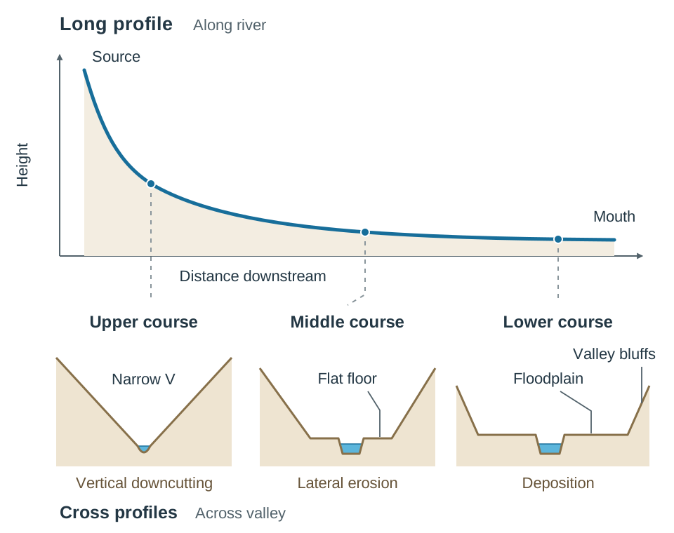
A river's long profile shows its height from source to mouth. In an undisturbed catchment, it forms a smooth concave curve that starts steep in the hills, eases off in the middle reaches, and flattens out near the coast. Over time, as knickpoints wash away and hollows fill up with gravel, the river moves towards a graded profile. At this stage, slope, discharge, and velocity balance the sediment load being carried.
A cross profile shows the valley shape from side to side at any station along the river:
- Upper course: A narrow, steep V-shape where potential energy drives vertical downcutting.
- Middle course: A wider, open V-shape with a flat valley floor, shaped by lateral erosion.
- Lower course: A broad, flat plain bounded by valley bluffs where deposition dominates.
Spotting Fluvial Features on a 1:50 000 OS Map
- V-shaped valley: Contour lines lie close together and form sharp V-shapes pointing uphill towards higher ground.
- Meanders: Winding, looping blue lines meandering across wide valley floors with very few contour lines.
- Oxbow lake: A curved, crescent-shaped loop of blue water sitting cut off on the floodplain beside the main river.
- Floodplain: A broad expanse of open, flat ground flanking the channel, shown by an absence of contours, spot heights, and few roads or settlements.
- Natural levees: Usually too low to produce contour lines. Look for embankment symbols running along riverbanks across flat plains, often with few buildings right beside the water.
- River confluence: The point where two blue river lines join. Write down the four-figure or six-figure grid reference required by the question.
Fluvial Processes and Drainage Patterns
The energy of a river comes from its water volume and velocity. Once friction against the bed and banks is overcome, surplus energy powers three related processes: erosion, transportation, and deposition.
Fluvial Erosion
- Hydraulic action: The physical force of turbulent water pounding against the bed and banks, prising loose stones away. In churning water beneath waterfalls, tiny vapour bubbles form and collapse. This implosion sends out shockwaves that weaken solid rock, a process called cavitation.
- Abrasion: The scouring and scraping of the bed and banks by sand, gravel, and boulders carried along in the river's load.
- Attrition: The constant bumping together of moving rocks. Sharp edges snap off, turning jagged stones into smooth, rounded pebbles and silt.
- Solution (corrosion): The chemical dissolving of soluble rocks like limestone and chalk by weak carbonic acid in rainwater and runoff.
Fluvial Transportation
- Traction: Large boulders and cobbles rolled along the riverbed during peak discharge.
- Saltation: Small stones and coarse sand grains bouncing along the bed in short hops.
- Suspension: Fine particles of silt and clay carried within the water column, giving floodwaters their murky brown tint.
- Solution: Dissolved minerals carried invisibly in the water without needing high current speeds.
Fluvial Deposition and Drainage Patterns
When a river slows down or loses volume, it drops its load. Large boulders settle first, followed by gravel, sand, and fine silt. This happens where the gradient levels off, where a channel widens, or where a river enters standing water like a lake or sea.
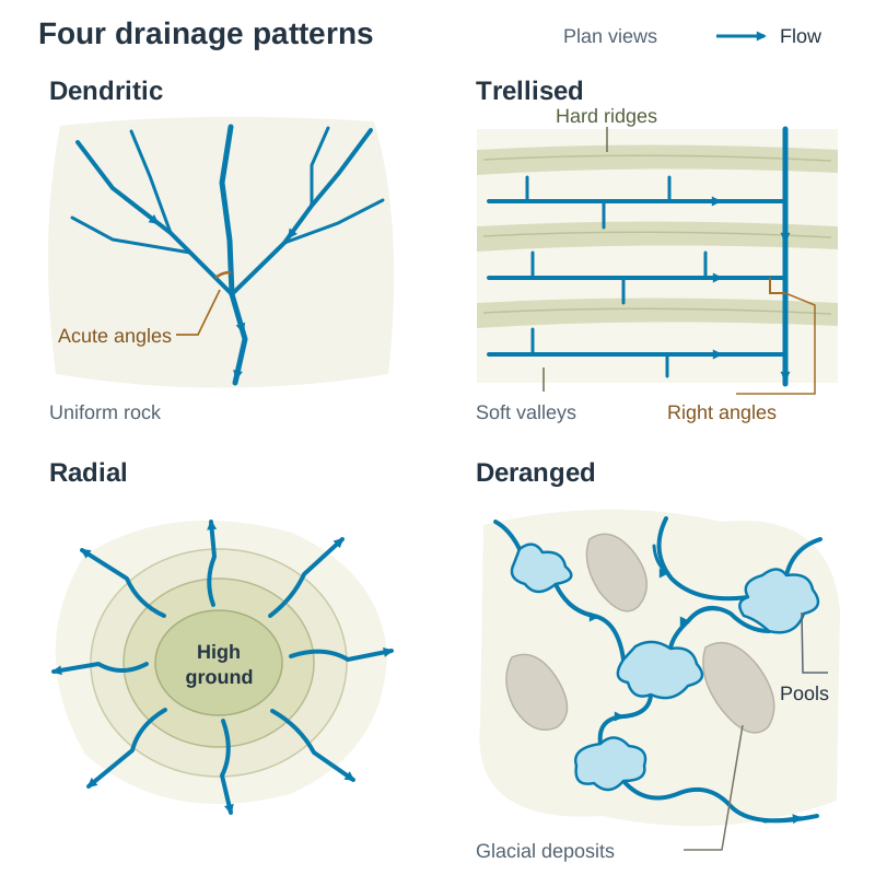
Over time, river networks form clear geometric drainage patterns depending on the rock underneath:
- Dendritic: Looks like the branching limbs of a tree, with tributaries joining the main river at acute angles. It forms over uniform rock types, such as across the Irish central lowlands.
- Trellised: Tributaries join the main channel at sharp right angles. This happens in folded rock belts where hard ridges alternate with soft valley beds, like the Munster ridge-and-valley province.
- Radial: Streams flow outwards in all directions from a central highland dome or cone, like spokes on a wheel. Streams running off Croagh Patrick in County Mayo show this pattern.
- Deranged: A messy, disordered tangle of streams, pools, and bogs. It develops where glacial deposits disrupt older drainage paths, as seen across drumlin belts in counties Cavan and Leitrim.
Upper Course: Youthful Landforms
In the upper course, steep gradients give rivers high energy. Most of this energy goes into vertical erosion, cutting the channel straight downward into the bedrock.
V-Shaped Valleys and Interlocking Spurs
Vertical downcutting by hydraulic action and abrasion carves a deep trench into upland bedrock. As the bed deepens, freeze-thaw weathering attacks the exposed valley walls, aided by mass movement like soil creep and scree falls. Loose rock slides down into the channel, where the river sweeps it downstream. This action turns the vertical notch into a steep V-shaped valley. Because the youthful river lacks the energy to cut straight through harder rock barriers, it winds around them. These alternating ridges jut out from opposite valley walls and seem to weave together, creating interlocking spurs. Good Irish examples include the upper River Liffey and Glenmacnass in County Wicklow.
Waterfalls and Gorges
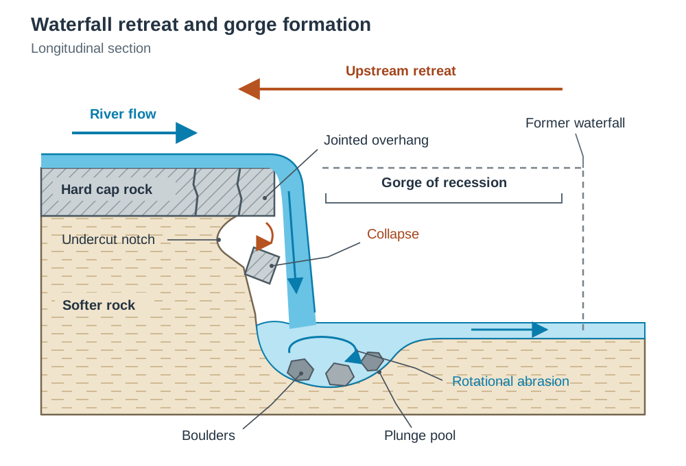
A waterfall marks a sharp vertical step in a river's long profile, caused by differential erosion between hard and soft rock layers:
- A band of tough cap rock sits over a layer of softer rock, as seen at Niagara Falls where Lockport dolomite rests on Rochester shale.
- Running water cuts into the softer rock much faster through hydraulic action and abrasion, opening a vertical drop.
- The plunging water slams into the riverbed below, gouging out a deep hollow known as a plunge pool.
- Swirling eddy currents spin loose boulders in the plunge pool, grinding the bed deeper through rotational abrasion. Water splashing back against the cliff face dissolves and cuts into the soft strata, leaving an undercut notch.
- As undercutting goes deeper, the overlying cap rock loses its physical support. Strained by open vertical joints, the unsupported ledge collapses into the plunge pool.
- Fallen boulders break down through attrition and act as grinding tools, gouging out the pool even further. Repeated undercutting and collapse force the waterfall to retreat upstream by headward erosion.
- This retreat leaves behind a steep-sided, narrow valley called a gorge of recession, like the 11 km gorge below Niagara Falls. In Ireland, Powerscourt Waterfall, Co. Wicklow, cascades over steeply dipping schist on the steep backwall of a glacial corrie. The granite–schist contact lies some distance upstream, so it is not a simple hard-over-soft waterfall.
Middle Course: Mature Landforms and Valley Widening
As the river enters its middle course, the valley gradient eases off and tributary flow swells the discharge. At this stage, lateral erosion takes over from vertical downcutting, swinging the channel sideways and opening up a wide valley floor.
Meander Dynamics
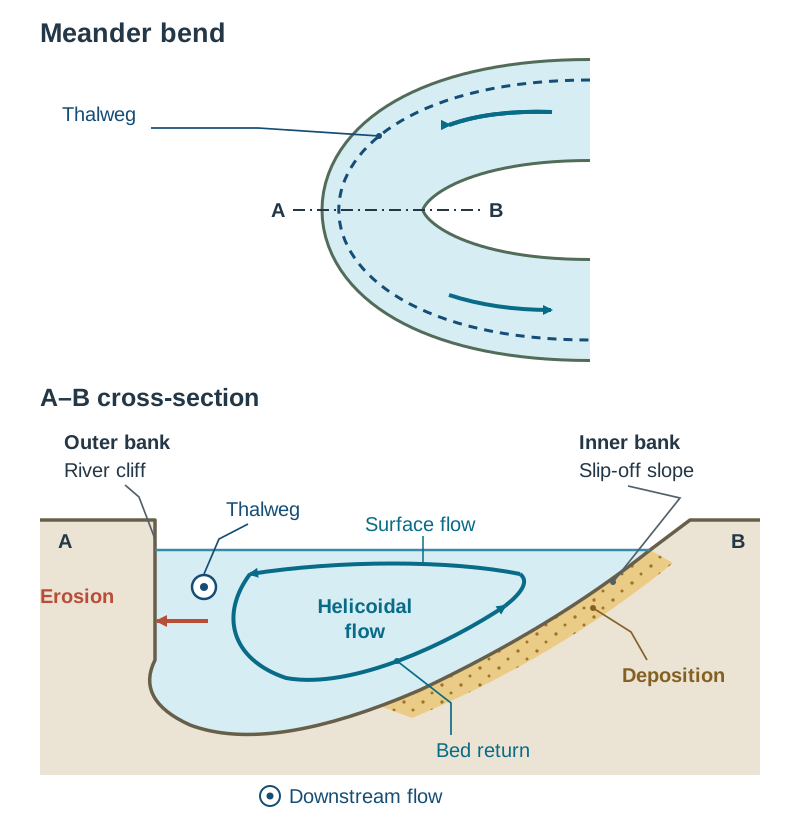
Meanders are sweeping, S-shaped curves that develop across low-gradient land. Water naturally weaves between shallow riffles and deeper pools. As water rounds a bend, it spirals in a corkscrew pattern known as helicoidal flow. Surface water heads towards the outer bank, while a slower bottom current carries eroded sediment back across the bed to build the inner slip-off slope.
- Outer bank (river cliff): Centrifugal force swings the fastest current, called the thalweg, against the outside bank. Intense lateral erosion by hydraulic action and abrasion undercuts the bank, causing rockfalls and leaving a steep river cliff.
- Inner bank (slip-off slope / point bar): Water moves much more slowly on the inside curve due to friction with the shallow bed. Losing the energy to carry its load, the river deposits sand and gravel, building a gently shelving slip-off slope or point bar.
Over time, meanders migrate across the valley floor and move downstream. This lateral sweep slices away the tips of interlocking spurs, carving out a wide valley floor bordered by low valley bluffs.
Diagram advice for the exam: Draw a clear cross-section of a meander bend showing a steep river cliff on the outside, a gentle slip-off slope on the inside, the thalweg positioned close to the outer bank, and a circular arrow indicating helicoidal water movement.
Lower Course: Old-Age Landforms and Deltas
In the lower course, the gradient turns almost flat, discharge reaches its peak, and deposition dominates as the river nears base level.
Oxbow Lakes
As a meander loop grows more pronounced, lateral erosion narrows the strip of dry land between the two outer bends, called the neck. During a heavy flood, the swollen river takes the steepest, most direct path and cuts straight through the neck. The new channel scours out quickly, taking the main flow. When floodwaters fall, current speed in the bypassed loop drops to zero, so sediment drops out of suspension. Mud and sand seal off both ends of the old bend, leaving an isolated crescent of water called an oxbow lake. Over time, the lake silts up with alluvium and rotting vegetation, leaving a marshy depression known as a meander scar. You can spot these along the Shannon Callows near Shannonbridge and on the lower River Moy in County Mayo.
Natural Levees and Floodplains
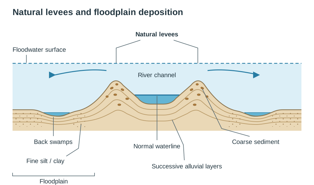
A floodplain is the flat valley floor flanking a mature or old-age river. It is carved out by migrating meanders and blanketed in fine silt during overbank floods. Natural levees are raised sediment ridges lining the channel banks:
- When river volume exceeds bankfull discharge, water spills out across the flat plain. The sudden drop in depth and increased friction with valley vegetation cuts water velocity instantly.
- The river drops its coarsest, heaviest load, like sand and gravel, right along the edges of the channel.
- Finer silts and clays travel further into the floodplain before settling out in thin sheets.
- Repeated floods over hundreds of years pile up coarse sediment along the banks, forming raised ridges called natural levees.
During dry spells, sediment continues to settle on the riverbed, lifting the channel floor above the surrounding land. Side streams running down the valley often cannot climb over these raised banks, pooling into soggy hollows called back swamps.
Deltas
A delta is a low-lying tract of alluvium built where a river empties into a lake or sea. Three conditions are needed for a delta to form: the river must carry plenty of sediment, coastal waves and tides must be gentle enough not to wash it away, and the river must lose speed suddenly on entering standing water. Deposited sediment settles into three distinct layers: horizontal fine bottomset beds far offshore, sloping coarser foreset beds on the delta front, and flat topset beds across the surface. As the mouth chokes with silt, the channel splits into smaller branches called distributaries. Deltas fall into three shapes: arcuate (fan-shaped, like the Nile Delta), bird's foot (distributary fingers branching into open water, like the Mississippi Delta), and estuarine (sediment partly filling an open river mouth). Ireland has few marine deltas because strong Atlantic waves and wide tidal ranges wash sediment away before it can pile up.
River Rejuvenation, Base Level, and Peneplains
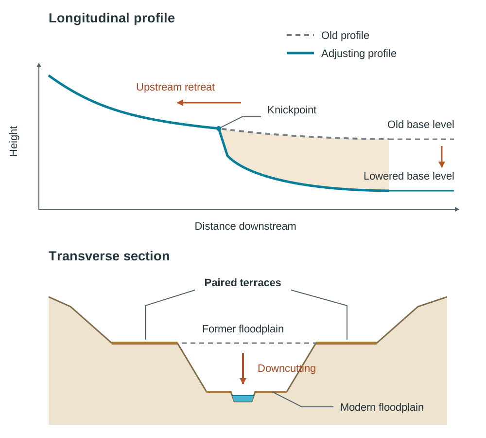
A river's base level is the lowest point to which it can erode its channel, with sea level forming ultimate base level. If sea level drops or the land rises, the river gains extra potential energy and cuts down into its old valley floor. This renewal of erosive power is called river rejuvenation.
Causes of Rejuvenation
- Eustatic fall in sea level: A global drop in ocean levels, as happened during ice ages when huge quantities of water were locked up in continental glaciers.
- Isostatic readjustment: The vertical rebound of the Earth's crust. When massive ice sheets melted after the last ice age, the unloaded crust rose slowly. In Ireland, the northern half is still rising by over 1 mm each year, giving rivers extra cutting energy, while the southern half is slowly sinking.
Landforms of Base-Level Change
Where the land has risen relative to sea level, coastal landforms of emergence include raised beaches, abandoned sea cliffs, and raised wave-cut platforms, which line parts of the Antrim and Donegal coasts. Where base level has risen relative to the land (submergence), drowned river mouths form rias, like Bantry Bay and Kenmare River in Munster, or fjords in deep glacial troughs like Killary Harbour.
Fluvial Features Formed by Rejuvenation
- Knickpoints: A sharp break in slope along a river's long profile where the newer, steeper gradient cutting back from the mouth joins the older, gentler slope upstream. These are often marked by waterfalls or rapids, as seen on the River Erne.
- Paired terraces: Flat benches left sitting at matching heights on both valley sides above the modern floodplain. They represent the old valley floor before downcutting began, as seen along the River Barrow and River Suir.
- Incised meanders: Meanders carved deeply into solid bedrock by renewed vertical downcutting. If incision is fast, symmetrical entrenched meanders form; if the river continues swinging sideways while downcutting, asymmetrical ingrown meanders develop, as seen along the River Nore near Inistioge in County Kilkenny.
Cyclic Landscape Development and Peneplains
Left undisturbed for millions of years, river erosion will wear an upland down to an almost flat erosion surface called a peneplain. Isolated hills of resistant rock that survive above this level are called monadnocks. If that plain is later uplifted, rivers rejuvenate and dissect the plateau, leaving flat-topped upland surfaces known as planation surfaces, which can be traced across parts of Munster.
Human Interaction: Catchment Engineering and Flood Control
People modify river channels and catchment hydrology for hydroelectric power, flood defence, and commercial shipping. These engineering schemes change how rivers erode, carry, and deposit sediment.
The River Shannon: Hydroelectric Development at Ardnacrusha
The Shannon runs 360 km across the Irish midlands with a very gentle slope, dropping just 76 metres from source to mouth. In 1925, the Irish Free State launched the Shannon Scheme to generate electricity at Ardnacrusha, County Clare, taking advantage of a 30-metre drop over the river's final 20 km.
At Parteen Weir, engineers diverted two-thirds of the Shannon's discharge into an artificial 12.8 km headrace canal to feed the turbines. While Ardnacrusha supplied most of the new state's electricity, it disrupted natural river processes:
- Diverting discharge into the canal starved the natural riverbed between Parteen and Limerick of water. Current speeds dropped, triggering heavy silt deposition that choked gravel spawning beds.
- The dam and weir blocked upstream migration paths for Atlantic salmon and eels. Even with a fish pass installed, fish numbers in the catchment fell significantly.
- Managing water levels on Lough Derg for electricity generation remains a source of local dispute during winter floods along the middle Shannon.
The Mississippi River: Levees and Channel Management
The Mississippi drains 31 US states and carries over 300 million tonnes of freight each year. The US Army Corps of Engineers has altered the river system extensively:
- Locks and dams: 29 locks and dams along the upper Mississippi maintain a 2.7-metre shipping channel. However, concrete dams trap bedload, starving downstream floodplains and coastal marshes of fresh alluvium.
- Wing dykes and revetments: Stone wing dykes stick out into the channel to narrow flow, speeding up the current to scour navigation channels clear. Concrete mattress revetments line the banks to halt lateral erosion.
- Artificial levees: More than 2,500 km of earth and concrete embankments confine the lower river. By stopping natural overbank floods, levees stop alluvium from replenishing farmland. Sediment settles on the riverbed instead, lifting the river channel above the surrounding plain.
- Loss of wetlands and flood hazards: Because dams and levees trap sediment, the delta receives less mud. This is one reason coastal Louisiana lost about 4,833 km² of land between 1932 and 2016, roughly a quarter of its 1932 land area (USGS, 2017). The rate of loss peaked in the 1970s and has slowed since. During the 1993 Midwest floods, water trapped between high levees built up immense pressure, bursting defences across the Upper Mississippi and Missouri basins and causing over $15 billion in damage. In 2005, a storm surge from Hurricane Katrina overtopped and breached drainage canal floodwalls and levees in New Orleans, leaving nearly 80% of the city underwater by 31 August.
Key terms
- Hydraulic Action
- The mechanical erosion of a riverbed and banks caused by the physical impact and pressure of moving water.
- Abrasion
- The mechanical scouring and scratching of the river channel by sand, gravel, and boulders carried in the river's load.
- Attrition
- The wearing down and rounding of sediment particles as they collide with one another while being moved downstream.
- Cavitation
- An erosion process where tiny vapour bubbles form in churning water and collapse violently, sending shockwaves that crack bedrock.
- Helicoidal Flow
- A corkscrew-like water motion across a meander channel that drives surface water to the outer bank and returns along the riverbed toward the inside bank.
- Thalweg
- The continuous line following the deepest points along a river channel, marking the line of fastest current speed.
- Base Level
- The lowest elevation to which a river can erode its channel, with world sea level representing ultimate base level.
- Rejuvenation
- The renewal of a river's vertical downcutting energy triggered by an isostatic crustal rise or a eustatic sea-level fall.
- Knickpoint
- A sharp break of slope along a river's long profile marking where a newly rejuvenated channel profile meets the older valley floor upstream.
- Paired Terraces
- Flat, step-like benches left perched at matching heights on both valley sides when a rejuvenated river cuts down into its former floodplain.
- Peneplain
- A low-relief, nearly flat erosion plain produced at the end of an erosion cycle by long periods of river denudation.
- Confluence
- The geographical point where a tributary stream or river joins another river.
- Graded Profile
- A smooth, concave long profile where a river's slope, velocity, and discharge balance its sediment load so erosion and deposition are equalised.
- Alluvium
- Fine mineral sediment made of sand, silt, and clay deposited by a river across its floodplain during overbank floods.
Check yourself
Name two landforms produced by river rejuvenation.
Knickpoints, paired terraces, or incised meanders.
What is the geographical term for the point where two rivers or streams meet?
A confluence.
Which drainage pattern resembles the branches of a tree and develops on uniform rock?
Dendritic drainage pattern.
True or false: deranged drainage patterns are common in landscapes shaped by glacial deposition.
True (commonly found in drumlin swarms in counties Cavan and Leitrim).
What is the name of the corkscrew water motion that drives meander formation?
Helicoidal flow.
Name two coastal landforms found where the land has risen relative to sea level (emergence).
Raised beaches, abandoned sea cliffs, or raised wave-cut platforms.
What term describes an almost flat plain produced at the end of a cycle of river erosion?
A peneplain.