

Regional Geography (Core Unit 2) examines how physical, economic, and human processes interact across geographical space. For Leaving Certificate Higher Level, students study the concept of a region across selected physical, administrative, cultural, socio-economic, and nodal criteria; analyse the dynamics of two contrasting Irish regions—the Greater Dublin Area (core) and the Western Region (periphery); and evaluate regional complexity, boundary changes, and regional development policies designed to tackle regional imbalance.
The Concept of a Region in Ireland
A region is an area of the earth's surface that can be identified by selected criteria operating at a variety of scales. Single or multiple indices may be used to identify it. Geographers classify regions using physical, administrative, cultural, socio-economic, and nodal criteria.
1. Climatic Regions
Defined by long-term atmospheric patterns. Ireland belongs to the Cool Temperate Oceanic climatic region, moderated by the North Atlantic Drift and prevailing south-westerly winds. Regional variations exist between the sheltered, drier east coast and the exposed, high-precipitation Atlantic seaboard.
2. Geomorphological Regions
Defined by rock type, tectonic history, and landforms shaped by weathering and erosion:
- Karst Landscapes (The Burren, Co. Clare): A glaciated karst plateau formed on Carboniferous limestone. Rainwater absorbs atmospheric carbon dioxide to form weak carbonic acid, dissolving calcium carbonate through carbonation:
Soluble calcium bicarbonate is removed in solution, opening vertical joints into deep fissures (grykes) separated by exposed limestone slabs (clints). Surface drainage is largely absent, disappearing into swallow holes to form underground caves (e.g. Aillwee Cave) and seasonal fluctuating lakes (turloughs).
- Munster Ridge and Valley (South Munster): Formed roughly 300 million years ago during the Armorican folding period. Intense north-south tectonic compression buckled the crust into east-west trending upfolds (anticlines) of resistant Old Red Sandstone, forming ridges like the Galtees, Comeraghs, and MacGillycuddy's Reeks. Softer limestone downfolds (synclines) eroded into river valleys (the Blackwater, Lee, and Bandon). The rivers first flow east along the soft limestone synclines, then turn sharply south and cut deep gorges straight across the sandstone ridges (for example the Blackwater turning south at Cappoquin)—a pattern explained by superimposed drainage laid down on a former cover of younger rock and later captured.
3. Administrative Regions
Defined by legal and statutory boundaries for government, resource distribution, and planning. Ireland contains 31 local authorities (county and city councils) and 43 Dáil electoral constituencies (e.g. Sligo-Leitrim). At the strategic level, Ireland is divided into three Regional Assemblies: Northern and Western, Eastern and Midland, and Southern.
4. Cultural Regions
Defined by shared linguistic, historical, or religious traits:
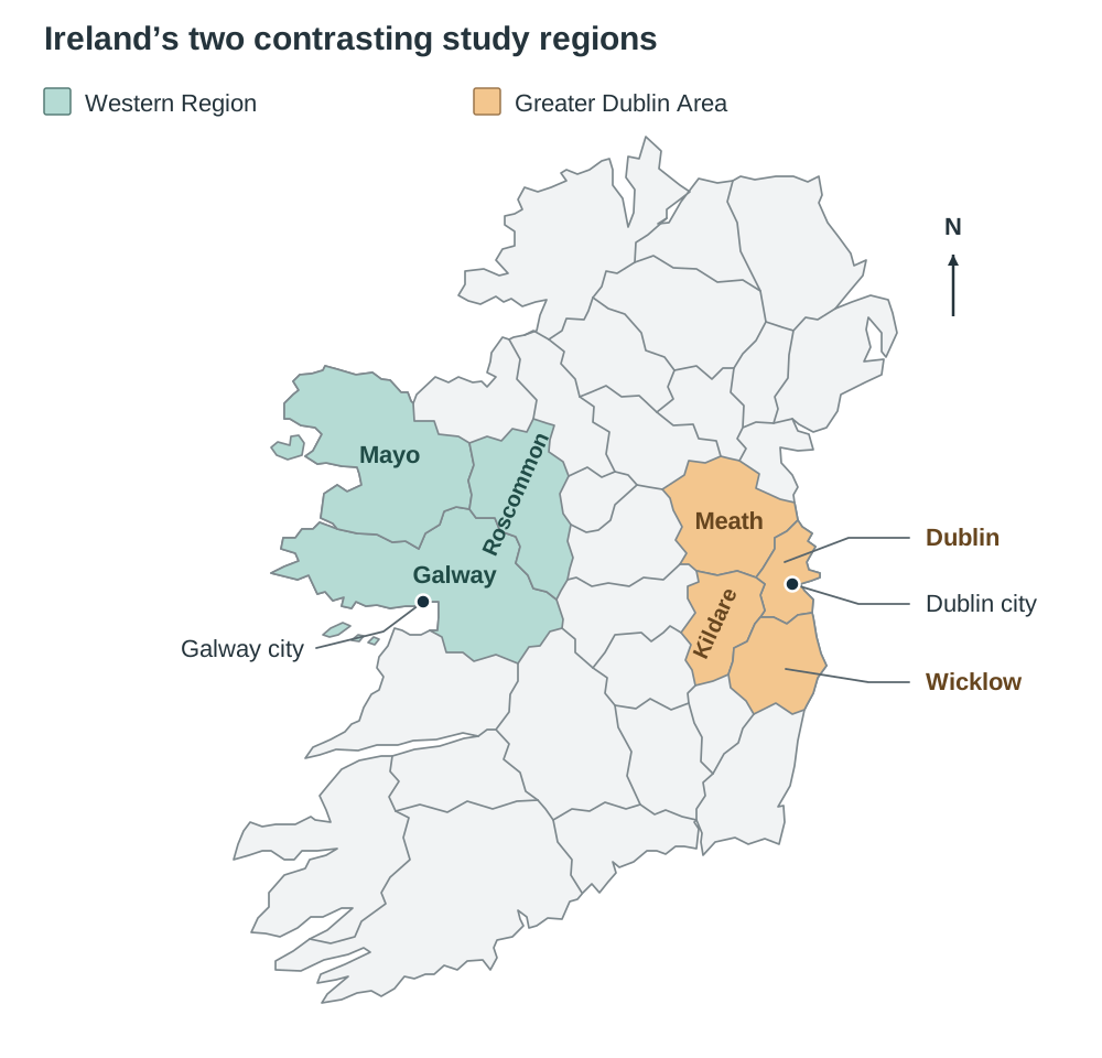
- Linguistic: Gaeltacht districts are statutory cultural regions where Irish is the protected community language, located primarily in Galway, Mayo, Donegal, Kerry, Cork, Waterford, and Meath.
- Religious: Northern Ireland historically developed territorial divisions between predominantly nationalist Catholic and unionist Protestant communities. In the Republic, religious traditions identify major pilgrimage landscapes like Knock and Croagh Patrick.
5. Socio-Economic and Nodal Regions
- Core Regions: Economically dominant regions with high incomes, advanced infrastructure, modern manufacturing, tertiary service clustering, and net inward migration (e.g. the Greater Dublin Area).
- Peripheral Regions: Remote areas with lower disposable incomes, dependence on primary activity and seasonal tourism, outward migration of young adults, and weaker infrastructure (e.g. the Western Region).
- Regions of Industrial Decline: Former manufacturing hubs that suffered deindustrialisation and factory closures, such as the Ruhr Valley in Germany or Belfast following the decline of its linen and shipbuilding trades.
- Nodal (City) Regions: Formed by a central urban node and the surrounding commuter area that depends on it. The hinterland is the area served by the city, while the sphere of influence describes how far the city's pull on workers, shoppers, patients, and students reaches. Dublin is Ireland's primate city; its commuter hinterland extends into Louth, Carlow, and Westmeath, while its sphere of influence for specialised services like the IFSC and Dublin Airport encompasses the entire country. Galway acts as the nodal centre for the Western Region, serving south Galway, east Mayo, and Roscommon with retail, higher education, and regional hospital care.
Single-Index, Multiple-Index, and Boundary Nature
Regions can be classified by one feature or many. Single-index regions use one criterion (such as rainfall or rock type), while multiple-index regions combine several (socio-economic regions use income, employment, migration, and infrastructure together). Administrative boundaries are drawn by law as exact lines, but physical, cultural, and economic boundaries are almost always transition zones that fade gradually into surrounding areas. Regions are also internally uneven: Galway City is a prosperous med-tech growth hub inside an otherwise peripheral western region.
Physical Processes: Greater Dublin Area vs Western Region
Relief, climate, soils, and drainage set limits on what the land can be used for, on where people live, and on which economic activities can succeed—and these limits are very different in the two regions.
Relief and Drainage
- Greater Dublin Area (Core): Underlain primarily by Carboniferous limestone, creating gently undulating lowland plains across Meath, Kildare, and North Dublin. Caledonian fold mountains (the Dublin and Wicklow Mountains) frame the southern edge, formed 400 million years ago with a granite batholith core and metamorphic schist margins. Permeable limestone and mature river basins (the Liffey, Tolka, and Boyne) ensure natural, effective drainage into the Irish Sea with minimal widespread waterlogging.
- Western Region (Peripheral): Dominated by rugged Caledonian fold mountains (Twelve Bens, Maumturks, Croagh Patrick) composed of resistant quartzite and schist. Glaciers during the Pleistocene carved corries, U-shaped valleys, and flooded coastal inlets like Killary Harbour. Impermeable boulder clay and drumlin swarms (e.g. Clew Bay) disrupt drainage, causing deranged drainage patterns and severe winter flooding along the slow-moving River Shannon and River Suck.
Climate
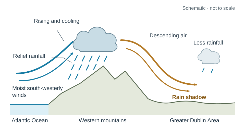
- Greater Dublin Area: Situated in the leeward rain shadow of western mountain ranges, the GDA receives between 750 mm and 850 mm of annual precipitation. It averages 4 hours of daily sunshine and warm summer temperatures of 16°C in July, benefiting from low cloud cover and shelter from prevailing south-westerly Atlantic depressions.
- Western Region: Directly exposed to warm, moisture-laden prevailing south-westerly winds. As air hits coastal mountains, orographic lifting forces it to rise, cool, and condense, generating intense relief rainfall. Annual precipitation exceeds 1,500 mm on lowlands and surpasses 2,500 mm in upland Connemara and Mayo. Average July temperatures reach 15°C, with cloud cover restricting daily sunshine to approximately 2.3 hours.
Soils
- Greater Dublin Area: Deep, fertile brown earth soils predominate across the lowlands, developed under post-glacial deciduous woodland where leaf litter formed neutral, mineral-rich humus. Limestone drift provides high calcium content, enhancing soil structure and aeration. Marine deposits in North County Dublin provide light sandy loams ideal for commercial horticulture. Infertile peat is restricted to upland slopes in the Dublin and Wicklow Mountains.
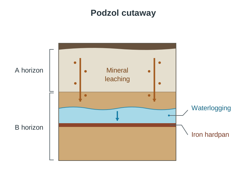
- Western Region: Intense, persistent rainfall causes severe leaching, washing soluble bases, aluminium, and iron oxides from the upper A horizon down into the B horizon. These minerals cement into an impermeable iron hardpan, forming acidic, poorly aerated podzol soils. In lowlands with poor drainage, saturated, oxygen-depleted gley soils dominate, colonised by rushes. High ground across Mayo and Connemara is blanketed by waterlogged blanket bog, making arable cultivation impossible.
Primary Economic Activities: Farming, Forestry, Fishing, and Energy
Physical conditions and market access dictate land productivity and resource extraction across both regions.
| Primary Sector Indicator | Greater Dublin Area (Core) | Western Region (Peripheral) |
|---|---|---|
| Agricultural Structure | Commercialised, capital-intensive, specialised arable, dairy, and horticulture. Average farm size is well above the national average. Farm incomes are consistently among the highest in Ireland (Teagasc National Farm Survey). | Pastoral, extensive sheep and suckler beef rearing. Small, fragmented holdings. Incomes are well below average, with high dependence on EU Common Agricultural Policy (CAP) payments and off-farm work. |
| Horticulture and Crops | High yields supported by flat terrain and mechanisation. Drier summers reduce potato blight risk. Commercial glasshouses flourish in North County Dublin (e.g. Rush and Lusk). | Arable cropping is unviable due to high rainfall, acidic podzols, and waterlogged gleys. Land use is restricted to rough hill grazing and silage production. |
| Specialist Farming | Bloodstock industry in Kildare; calcium-rich limestone soils and nutrient-dense grass develop strong bone structures in thoroughbred horses (Irish National Stud, The Curragh). | High levels of part-time farming, with farmers relying on off-farm employment to supplement income. |
| Forestry | Minimal commercial forestry; lowland is too valuable for agriculture. Woodlands in Wicklow foothills are used for urban recreation and tourism. | Extensive commercial afforestation on marginal upland blanket bogs, dominated by monoculture conifers (Sitka Spruce) planted by Coillte. |
| Fishing & Aquaculture | Accounts for 2% of the national catch. Howth is the main port (Dublin Bay prawns). Shellfish face historical water quality challenges in the Irish Sea. | Essential coastal activity. Major deep-water fishing port at Ros a' Mhíl (Rossaveal) in Connemara. Aquaculture flourishes in sheltered Atlantic inlets (mussels in Killary Harbour, oysters at Clarinbridge, and salmon farms in Clew Bay). |
Mining and Energy
- Greater Dublin Area: Tara Mines in Navan, Co. Meath—Europe's largest underground zinc mine—shows how vulnerable primary extraction is: low world zinc prices and high energy costs forced Boliden to suspend production in 2023, affecting about 650 jobs, with only a phased restart since. Mining depends on a fixed resource and on prices set on world commodity markets.
- Western Region: Natural gas from the offshore Corrib gas field has been processed at the onshore terminal in Bellanaboy, Co. Mayo, since 2015. Historic peat-fired electricity generating stations have closed (Bellacorick, Co. Mayo, in 2003, while the neighbouring Midlands stations at Shannonbridge, Co. Offaly, and Lanesborough, Co. Longford, closed in 2020 as part of the same national peat phase-out), replaced by renewable infrastructure including the Oweninny Wind Farm on cutaway bog in Mayo and the Galway Wind Park in Connemara.
Secondary Economic Activities: Manufacturing Dynamics
Industrial development illustrates contrasting access to skilled labour, transport links, and foreign direct investment (FDI) between the two regions.
Greater Dublin Area (Core)
The GDA is Ireland's primary hub for modern, high-value, footloose multinational corporations (MNCs) in pharmaceuticals, biomedical products, and technology.
- Locational Advantages: Rapid access to Dublin Airport for high-value air freight and Dublin Port for roll-on/roll-off shipping; the largest concentration of third-level institutions in the State (Trinity College Dublin, UCD, DCU, TU Dublin, Maynooth University), supplying a large, highly qualified graduate labour pool on the doorstep of employers; a competitive corporation tax rate; and modern serviced industrial estates along the M50 motorway (e.g. Grange Castle, Citywest, Sandyford).
- Advance Factories: State agencies like the Industrial Development Authority (IDA Ireland) provide modern, pre-constructed, fully serviced industrial buildings that eliminate construction delays, allowing multinational companies to establish production rapidly.
- Flagship Case Studies:
- Intel (Leixlip, Co. Kildare): A multi-billion-euro semiconductor fabrication facility employing thousands of skilled technicians and engineers manufacturing microprocessors.
- Pfizer (Grange Castle, Clondalkin): One of the world's largest biotechnology facilities, producing vaccines (Prevnar 13) and treatments for rheumatoid arthritis (Enbrel).
- Agri-Food Processing: Commercial agriculture supplies large-scale processing, including Diageo (St. James's Gate brewery, Dublin), Largo Foods / Tayto (Ashbourne, Co. Meath), and meat processing facilities.
Western Region (Peripheral)
Outside Galway City, manufacturing has historically relied on small-scale, labour-intensive operations processing local primary resources like timber, textiles, and livestock. Industrial wages average roughly 15% below national figures.
- Barriers to Industry: Low population density (about 25 persons per km² in Mayo), outward migration of third-level graduates, broadband blackspots, and single-carriageway national roads (such as parts of the N5 and N17) that increase transport times to eastern ports.
- Traditional Processing Case Study: Kepak operates a meat processing plant in Athleague, Co. Roscommon, processing cattle and sheep from regional farms. Because it operates on tight margins, it remains vulnerable to agricultural price fluctuations and operating costs.
- The Galway City Med-Tech Growth Pole: Galway functions as an urban exception, hosting a world-class med-tech cluster supported by biomedical research partnerships with the University of Galway and Atlantic Technological University (ATU):
- Boston Scientific (Ballybrit, Galway): Employs over 2,600 people developing and manufacturing cardiovascular catheters and stents for global export.
- Medtronic (Parkmore, Galway): Employs over 2,000 workers in medical device research, design, and precision manufacturing.
- Decentralised High-Tech Manufacturing: Allergan (AbbVie) in Westport, Co. Mayo, employs over 800 people producing Botox, demonstrating that high-tech manufacturing can succeed in peripheral towns with IDA backing. Additionally, Údarás na Gaeltachta provides financial grants and factory space to attract enterprise and light manufacturing into Gaeltacht communities.
Tertiary Economic Activities: Transport, Tourism, and Services
Services represent the largest employment sector in both regions, but their structure, scale, and seasonality differ significantly.
Transport Networks
- Greater Dublin Area: Focus of Ireland's transport network. Radial motorways (M1 to M11) converge on the M50 orbital ring road. Public transport includes the electrified DART, two Luas light rail lines, and dedicated core bus corridors developed under the BusConnects programme. Dublin Port handles the vast majority of national container and roll-on/roll-off freight, aided by the Dublin Port Tunnel. Dublin Airport is the primary international gateway, operating near its current 32-million passenger annual planning cap—a congestion challenge typical of an expanding core.
- Western Region: Transport development is constrained by rugged relief, low population density, and boggy ground. The M6 motorway connects Galway to Dublin, and the M17/M18 links Galway towards Limerick, but routes like the N5 and N59 retain single-carriageway sections. Rail relies on single-track lines. Only Phase 1 of the Western Rail Corridor (Ennis–Athenry) reopened, in 2010; the Athenry–Tuam–Claremorris section remains closed, meaning north–south transport depends on road. Ireland West Airport Knock provides critical regional air connectivity, handling over 800,000 passengers annually.
Tourism
- Greater Dublin Area: Dominates national tourism with a year-round market and low seasonality. The GDA attracts city-break visitors, business and conference tourists, and cultural visitors. Major attractions include the Guinness Storehouse, Trinity College (Book of Kells), Kilmainham Gaol, Dublin Castle, and events at the Curragh. Hotel accommodation achieves consistent year-round occupancy.
- Western Region: Highly seasonal, peaking between June and August. The industry depends on scenic landscapes and outdoor activities, marketed internationally via the Wild Atlantic Way. Key attractions include Connemara National Park, the cliffs of Achill Island, the off-road Great Western Greenway (Westport to Achill), the 5,000-year-old Céide Fields, and the National Famine Museum at Strokestown. In winter, rural accommodation and business closures cause serious seasonal underemployment.
Financial and Advanced Digital Services
Dublin is an international financial services hub driven by the International Financial Services Centre (IFSC), established in 1987 in the Custom House Docks. Benefiting from Ireland's corporate tax regime and skilled graduates, the IFSC hosts hundreds of financial institutions and employs over 35,000 professionals. Dublin also hosts the European headquarters of major digital technology multinationals (Google, Meta, LinkedIn) in the 'Silicon Docks', exporting internationally traded digital services.
Human Processes: Demographics, Language, Religion, and Settlement
Demographic and cultural processes reflect the economic divide between the core and the periphery.
1. Population Dynamics and Settlement Patterns
- Greater Dublin Area: Home to about 2.1 million people (Census 2022, CSO), roughly 40% of the State's total population of 5,149,139 (Dublin county: 1,458,154; Kildare: 247,774; Meath: 220,296; Wicklow: 155,851). Dublin City's density exceeds 4,800 persons per km², compared to a national average of about 73. Dublin functions as Ireland's primate city, disproportionately larger than any other urban centre. Rapid population growth driven by natural increase and inward migration creates severe housing shortages and commuter congestion. Commuter counties grew rapidly between 2016 and 2022 (Kildare and Meath both grew over 10%).
- Western Region: Characterised by low population density—about 25 persons per km² in Mayo and 28 in Roscommon (Census 2022). The region holds about 487,000 people (Galway city and county: 279,233; Mayo: 137,231; Roscommon: 70,259), under 10% of the national total. Between 2016 and 2022, Mayo grew by only about 5% (130,507 to 137,231), while Roscommon grew by about 9% (64,544 to 70,259) — still concentrated in towns such as Castlebar and Roscommon town rather than the open countryside. Dispersed one-off housing in the open countryside has led to service closures (schools, post offices, local shops).
- Age Structure and Migration: The Western Region has a high age-dependency ratio because of age-selective migration: young adults leave for third-level education and career opportunities, producing a brain drain and leaving an older average population. By contrast, the GDA has the highest proportion of adults aged 25–44, driving strong natural increase. Inward migration is a core-region feature: Census 2022 recorded about 12% of the State's population as non-Irish citizens, rising to roughly 20% in Dublin City.
2. Language as a Human Process
- Western Region: Contains the largest Gaeltacht in the State, Connemara (Cois Fharraige, Carna, An Cheathrú Rua) in Co. Galway, alongside smaller Gaeltacht districts in Tourmakeady, Co. Mayo, and on the Aran Islands (Oileáin Árann). Census 2022 recorded roughly 106,000 people living in Gaeltacht areas nationally, but only about 20% speak Irish daily outside the education system. Irish-language employment supports the regional economy: TG4 has its headquarters at Baile na hAbhann and RTÉ Raidió na Gaeltachta broadcasts from Casla; Údarás na Gaeltachta funds local enterprise; and summer Irish colleges bring thousands of second-level students to Gaeltacht households each summer, providing vital seasonal income to families.
- Greater Dublin Area: English is overwhelmingly the working language, but Irish operates as a taught and chosen language rather than an unbroken community one. Dublin has the largest concentration of Gaelscoileanna in the State, and County Meath contains a designated Gaeltacht enclave in Ráth Cairn and Baile Ghib, created through state land resettlement in the 1930s.
3. Religion as a Human Process
- Western Region: Retains a stronger traditional Catholic identity, where religion supports tertiary employment through pilgrimage tourism. Knock Shrine in Co. Mayo attracts over one million pilgrims annually and led directly to the construction of Ireland West Airport Knock. Croagh Patrick draws thousands of pilgrims on Reek Sunday each July, providing substantial business to Westport's hospitality sector.
- Greater Dublin Area: Census 2022 showed Roman Catholic identification falling to 69% nationally (down from 79% in 2016), with those declaring 'no religion' rising to 14%. Religious disaffiliation is happening faster in urban Dublin. Inward migration has created religious diversity: Dublin has the largest Muslim, Eastern Orthodox, Hindu, and Evangelical communities in Ireland, including the Islamic Cultural Centre of Ireland in Clonskeagh.
4. Working with Census Figures and Regional Numeracy
- Age-Dependency Ratio:
Worked Example: A rural western district records 2,400 children (0–14), 3,000 elderly residents (65+), and 9,000 working-age adults (15–64):
There are 60 dependents for every 100 working-age individuals.
- Percentage Change:
Worked Example: Population grows from 130,500 to 137,231:
(Always divide by the original earlier baseline figure, never the new one).
- Mean (Average) Calculation: Sum all values in the data set and divide by the number of values; always retain the exact units stated in the table (e.g. thousand tonnes or persons per km²).
- Missing Percentage Calculation: In a 100% distribution or pie chart, add all known segments and subtract the total from 100.
Regional Complexity, Boundary Changes, and Development Policy
The boundaries and extent of regions change over time. They shift because of political agreements, the outward growth of cities, changes in language use, and new economic planning policies.
1. Cross-Border Interaction: Republic of Ireland and Northern Ireland
- The 1920 Government of Ireland Act and 1921 Anglo-Irish Treaty created the partition of Ireland, establishing a 499-km political border separating six north-eastern counties from the rest of the island.
- The Boundary Commission of 1925 was intended to redraw the border along lines of community identity, but its report was shelved, confirming the 1920 county borders. The border cut directly through natural commercial hinterlands, farms, and roads, isolating border counties (such as Donegal, Cavan, Monaghan, Fermanagh, Tyrone, and Armagh) into peripheral zones.
- The 1998 Good Friday Agreement established six North/South implementation bodies, including Waterways Ireland, InterTradeIreland, and the Special EU Programmes Body; separately, Tourism Ireland was set up in 2002 to market the entire island overseas as a single destination.
- The Dublin-Belfast economic corridor (M1/A1 motorway and Enterprise rail line) and the all-island single electricity market integrated physical infrastructure.
- Following Brexit, the Windsor Framework avoided a hard customs border on the island by conducting regulatory checks on goods arriving from Great Britain at Northern Irish ports instead.
2. Evolution of Gaeltacht Boundaries Since 1850
- 1851 Census Baseline: The first official language census recorded roughly 1.5 million Irish speakers, concentrated along western and southern coasts.
- Decline Factors: The Great Famine caused disproportionate death and emigration among poor rural cottiers, devastating Irish-speaking communities. The 1831 national school system enforced English-medium education, while transatlantic emigration made English an economic necessity.
- 1926 Coimisiún na Gaeltachta: Divided districts into the Fíor-Ghaeltacht (80%+ Irish speaking) and Breac-Ghaeltacht (25–79% Irish speaking). Boundaries were drawn widely and included areas where daily Irish usage was already weakening.
- 1930s Resettlement Enclaves: In 1935 the Land Commission resettled the first group of Irish-speaking families (27 households) from Connemara onto fertile farms at Ráth Cairn, Co. Meath, with further families settled at Baile Ghib later in the 1930s, creating an entirely new Gaeltacht enclave in Leinster.
- 1956 Gaeltacht Areas Order: Redrew boundaries strictly around surviving spoken communities across seven counties, establishing the statutory Gaeltacht supported by the Department of the Gaeltacht and later Údarás na Gaeltachta (1980).
- Gaeltacht Act 2012: Replaced rigid geographical boundaries with 26 functional Language Planning Areas (LPAs). Communities must implement approved local language plans through Údarás na Gaeltachta to keep their statutory status and funding.
3. Dublin Local Government Reorganisation (1993/1994)
Rapid outward suburban sprawl overwhelmed the historic Dublin County Council. Under the Local Government (Dublin) Act 1993, Dublin County Council was abolished on 1 January 1994 and replaced by three distinct local authorities:
- Fingal County Council (Swords, Blanchardstown, Balbriggan)
- South Dublin County Council (Tallaght, Clondalkin, Lucan)
- Dún Laoghaire-Rathdown County Council (Dún Laoghaire, Dundrum, Sandyford)
Together with Dublin City Council, four separate councils now administer the capital's planning, housing, and roads. This shows how nodal growth forces administrative boundaries to adapt.
4. Policy for Regional Development and Reducing Regional Imbalance
Regional imbalance is the uneven distribution of population, wealth, and economic activity between the core and the periphery. In Ireland, the GDA accounts for roughly 40% of the population and generates over half of national Gross Value Added (GVA). Average disposable income in Dublin is around €28,000 per person, compared to roughly €21,000–€23,000 in western counties (CSO County Incomes). Several state and EU policies address this:
- Project Ireland 2040 / National Planning Framework (NPF): A statutory planning strategy aiming for compact, balanced regional growth so that 50% of future population growth happens outside Dublin. It targets 50% growth in Cork, Limerick, Galway, and Waterford to act as counterweights to Dublin, and designates Athlone and Sligo as regional growth centres.
- National Development Plan (NDP): Funds the enabling capital infrastructure, including motorway upgrades, water services, third-level facilities, and the National Broadband Plan to deliver high-speed fibre to rural premises.
- Regional Spatial and Economic Strategies (RSES): Prepared by each of the three Regional Assemblies to coordinate housing, employment land, and transport priorities across local authorities.
- Western Development Commission (WDC): A statutory agency promoting economic and social development across the seven western counties. It has developed the Connected Hubs remote-working network, allowing people to work for Dublin or international employers while living in western towns.
- Atlantic Economic Corridor (AEC): An initiative linking western urban centres from Donegal to Kerry via upgraded road, rail, and digital infrastructure to create a single connected labour market.
- EU Funding Status: From 1999 to 2017 Ireland was split into two NUTS 2 regions: Border, Midland and Western (BMW) and Southern and Eastern (S&E), ensuring the BMW region qualified for Objective 1 structural funds (GDP below 75% of EU average). Under the revised three-region structure, the Northern and Western region was reclassified in 2020 as a transition/lagging region because its GDP per head slipped relative to the EU average, confirming that peripherality remains an ongoing economic reality.
Comprehensive Regional Comparison: GDA vs Western Region
This comparative summary brings together the core processes tested in comparative exam questions:
| Geographical Process | Greater Dublin Area (Core) | Western Region (Peripheral) |
|---|---|---|
| Dominant Relief | Lowland Carboniferous limestone plains framed to the south by Caledonian Wicklow Mountains. | Rugged Caledonian mountains (Twelve Bens, Croagh Patrick) and coastal drumlin swarms. |
| Drainage | Well-drained by mature river systems (Liffey, Boyne) and permeable bedrock; low flood risk. | Deranged drainage, impermeable boulder clay, and winter flooding along the slow-moving Shannon and Suck. |
| Precipitation | 750 mm–850 mm annually; sheltered by rain-shadow effect from western mountains. | 1,500 mm to over 2,500 mm; high relief rainfall caused by orographic lifting of moist Atlantic air. |
| Summer Climate | Warm summers (16°C July average) with 4 hours of daily sunshine; longer growing season. | Cooler summers (15°C July average) with only 2.3 hours daily sunshine; shorter growing season. |
| Dominant Soils | Fertile brown earths with high calcium content; light sandy loams in north Dublin. | Heavily leached acidic podzols with an impermeable iron hardpan; saturated gleys; upland blanket bogs. |
| Primary Activities | Intensive commercial cereal, dairy, and horticulture; bloodstock breeding in Kildare. | Extensive sheep and suckler grazing; high reliance on CAP subsidies and off-farm employment; aquaculture. |
| Secondary Sector | High-tech multinationals (Intel, Pfizer) along the M50; advance factories; skilled graduate pool. | Traditional food processing (Kepak); med-tech cluster in Galway City (Boston Scientific, Medtronic); Allergan in Westport. |
| Tertiary Sector | Transport hub (M50, DART, Dublin Airport); international finance (IFSC); year-round city tourism. | Constrained transport (single-track rail, N5/N17); highly seasonal tourism along the Wild Atlantic Way. |
| Population Trends | Primate city; ~2.1 million residents; high density (>4,800/km² in Dublin City); younger age profile. | Under 500,000 people; low density (~25/km² in Mayo); brain drain, ageing population, high age-dependency ratio. |
| Language / Culture | Predominantly English-speaking; small Land Commission Gaeltacht enclave in Meath; multicultural. | Strong traditional culture; contains the Connemara Gaeltacht (TG4, Raidió na Gaeltachta, Irish colleges). |
| Religion | Cosmopolitan; growing secularisation ('no religion' 14%); major religious minority centres (Clonskeagh Mosque). | Stronger traditional Catholic identity; pilgrimage tourism generates tertiary jobs (Knock Shrine, Croagh Patrick). |
Key terms
- Core Region
- An economically dominant, densely populated region with high disposable incomes, modern infrastructure, tertiary clustering, and net inward migration (e.g. the Greater Dublin Area).
- Peripheral Region
- A remote, economically disadvantaged region with lower incomes, low population density, reliance on primary activities and seasonal tourism, and net outward migration (e.g. the Western Region).
- Geomorphological Region
- An area defined by its distinctive rock types, tectonic history, and surface landforms shaped by weathering and erosion, such as the karst Burren or the folded Munster Ridge and Valley.
- Carbonation
- The chemical weathering process where carbonic acid in rainwater dissolves calcium carbonate in limestone to form soluble calcium bicarbonate: CaCO3 + H2CO3 -> Ca(HCO3)2.
- Armorican Folding
- A mountain-building period roughly 300 million years ago that compressed southern Ireland along an east-west axis, creating sandstone anticlines and limestone synclines.
- Caledonian Folding
- A tectonic collision roughly 400 million years ago between the North American and Eurasian plates, forming northeast-southwest trending mountains in western Ireland and Wicklow.
- Rain-Shadow Effect
- A reduction in precipitation on the leeward side of a mountain barrier, caused when rising moist air cools and deposits its rainfall on windward slopes before descending.
- Podzolisation
- A soil formation process in cool, wet climates where severe leaching washes minerals from the upper A horizon into the B horizon, creating an acidic soil with an impermeable iron hardpan.
- Brown Earth Soil
- A fertile, well-drained, dark brown soil rich in humus, formed beneath temperate deciduous forests and commonly found across lowland eastern Ireland.
- Nodal Region
- A region defined by a central urban focal point (node) connected to the surrounding hinterland that relies on it for employment, retail, education, and services.
- Hinterland
- The surrounding rural or suburban area served by a central urban node for employment, trade, transport, and specialised services.
- Primate City
- A city that is disproportionately larger than any other in the country, dominating national economic, political, and cultural life (e.g. Dublin in Ireland).
- Advance Factories
- Pre-constructed, fully serviced industrial units built by development agencies like IDA Ireland to attract immediate inward foreign direct investment.
- Age-Dependency Ratio
- The ratio of dependent persons (those aged 0–14 and 65+) to the working-age population (aged 15–64), expressed per 100 working-age individuals.
- Brain Drain
- The outward migration of educated, skilled young adults from a peripheral region to major urban centres or overseas due to a lack of professional career opportunities.
- Gaeltacht
- Statutory districts in Ireland where the Irish language is protected as the primary community language, now administered under functional Language Planning Areas.
- Regional Imbalance
- The unequal geographic distribution of population, wealth, employment opportunities, and infrastructure between core and peripheral regions within a state.
- Project Ireland 2040
- The Irish government's overarching national planning framework aiming for balanced regional growth by directing 50% of future population growth to regional cities and towns outside Dublin.
Check yourself
Match each of these four Irish regions to its correct regional type: (a) The Burren, (b) Connemara Gaeltacht, (c) Sligo-Leitrim, (d) Greater Dublin Area.
(a) Geomorphological region, (b) Cultural (linguistic) region, (c) Administrative region, (d) Socio-economic core region (or Nodal region).
What chemical equation explains carbonation weathering in the Burren karst landscape?
CaCO3 + H2CO3 -> Ca(HCO3)2 (calcium carbonate reacts with carbonic acid to form soluble calcium bicarbonate).
Why is annual precipitation in the Greater Dublin Area (750–850 mm) less than half that of upland Connemara (>2,500 mm)?
The GDA lies in the leeward rain shadow of western mountains, whereas the West experiences intense relief rainfall as moisture-bearing prevailing Atlantic winds undergo orographic lifting over coastal peaks.
Name two multinational medical device manufacturers located in Galway City.
Boston Scientific (Ballybrit) and Medtronic (Parkmore).
What administrative reorganisation took place in Dublin on 1 January 1994 under the Local Government (Dublin) Act 1993?
Dublin County Council was abolished and replaced by three new local authorities: Fingal, South Dublin, and Dún Laoghaire-Rathdown, operating alongside Dublin City Council.
State the formula for calculating the age-dependency ratio from census population data.
Dependency Ratio = [ (Population aged 0–14 + Population aged 65+) / Population aged 15–64 ] * 100.
What is the key target of the Project Ireland 2040 National Planning Framework regarding regional growth?
It targets balanced regional growth by directing 50% of all future population and employment growth to regional cities and towns outside Dublin.
Why was Ireland divided into the Border, Midland and Western (BMW) and Southern and Eastern (S&E) regions in 1999?
To allow the poorer BMW region to retain EU Objective 1 funding status, as its GDP per capita remained below 75% of the EU average.