

In Leaving Certificate Higher Level Geography, a region is any area of the Earth's surface that we can identify and map using specific criteria. These criteria can be physical, like climate, relief, and rock type, or human, like language, political borders, and economic wealth. Geographers examine these areas across local, national, and continental scales. For your European case studies, you need a firm grasp of regional classifications, an in-depth comparison of two contrasting regions — the Paris Basin (a prosperous economic core) and the Mezzogiorno (a peripheral southern region) — and a clear understanding of how the European Union manages enlargement, structural funds, and national sovereignty.
What is a region?
A region is an area of the Earth's surface defined by selected criteria. Geographers divide space into regions to make large, complex areas easier to study and compare.
Climatic Regions
We define climatic regions using weather records kept over at least thirty years. North-west Europe experiences a cool temperate oceanic climate, kept mild by the North Atlantic Drift and prevailing south-westerly winds. Winters stay mild (averaging around 6°C), summers stay cool (15°C to 17°C), and rain falls right through the year, giving between 800 mm and 2,500 mm annually. In contrast, southern Europe has a Mediterranean climate where the Azores High pressure system brings summer droughts and temperatures above 25°C, followed by mild, damp winters.
Geomorphological Regions
Geomorphological regions share distinct relief, rock types, and drainage patterns. The North European Plain is a vast lowland stretching from northern France eastwards across Belgium, Germany, and Poland into Russia. Its gentle relief comes from marine sedimentary deposits and glacial drift. Karst regions, such as the Burren in County Clare, are formed by rainwater dissolving exposed Carboniferous limestone (carbonation), leaving bare pavements, clints, grikes, and underground cave systems.
Administrative Regions
Governments draw administrative borders so they can manage public services, organise voting, and collect taxes. Ireland is run through 31 local authorities — county councils, city councils, and city-and-county councils such as Limerick and Waterford — grouped into three regional assemblies for EU funding purposes. France relies on a three-tiered system made up of 13 mainland regions, 96 mainland departments each overseen by a government-appointed préfet, and roughly 35,000 local communes.
Cultural Regions
A cultural region brings people together through a shared language, religion, or way of life. In Ireland, Gaeltacht districts in Donegal, Mayo, Galway, and Kerry are peripheral areas where government policy protects the daily use of Irish. Belgium is a clear example of a divided language region. Dutch-speaking Flanders in the north holds about 60% of the population, while French-speaking Wallonia lies in the south. These deep linguistic divisions led Belgium to establish separate regional parliaments and school systems under a federal constitution.
Socio-Economic Regions
We classify socio-economic regions by measuring personal income, jobs, and levels of private and public investment:
- Core regions: Prosperous, heavily populated hubs with modern transport networks, corporate headquarters, and strong inward investment, such as the Paris Basin.
- Peripheral regions: Disadvantaged areas cut off from large markets by distance or difficult relief, suffering from lower wages and outward migration, such as southern Italy's Mezzogiorno.
- Regions of industrial decline: Areas that once boomed on coal, iron, or heavy manufacturing, but struggled once resources ran out or cheaper overseas competitors emerged. The Ruhr Valley in Germany built immense wealth on coal and steel, but faced pit closures and factory shutdowns from the 1960s onward. The Sambre-Meuse Valley in Wallonia went through the same cycle when its coal mines shut.
Nodal (Urban) Regions
A nodal region consists of a central city (the node) and its surrounding hinterland. Daily commuting, retail shopping, and regional freight corridors tie the hinterland directly to the urban core. Examples include the Greater Dublin Area and the Randstad in the Netherlands, an urban ring connecting Amsterdam, Rotterdam, The Hague, and Utrecht around an open farming interior known as the Green Heart.
European core region: the Paris Basin
The Paris Basin covers roughly one-fifth of France and contains a quarter of its population. The central Île-de-France region holds more than 12 million people. Its economic power rests on outstanding natural advantages backed by centuries of government planning.
Physical Processes
- Relief: The basin forms a large, shallow sedimentary saucer where more than 80% of the land sits below 200 metres. Concentric layers of sedimentary rock dip gently inwards towards Paris. Harder chalk and limestone ridges form asymmetrical escarpments known as cuestas, such as the Falaise d'Île-de-France, whose south-facing slopes catch maximum sunlight and drain naturally.
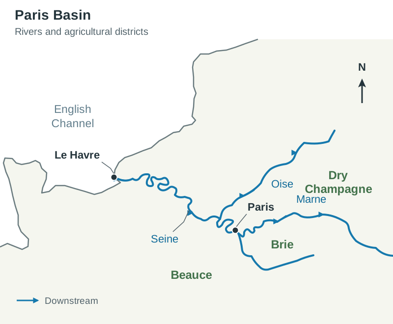
- Drainage: The navigable River Seine and its main tributaries (the Marne, Oise, and Yonne) flow across the basin floor. This river system supplies drinking water, supports industrial cooling, and gives Paris an inland freight route out to the deep-water port of Le Havre.
- Climate: A cool temperate oceanic climate prevails. January temperatures average 3°C, while July averages reach 18°C. Reliable rainfall between 600 mm and 700 mm arrives throughout the year, allowing cereals to ripen without regular drought.
- Soils: As Pleistocene glaciers retreated, winds picked up fine rock dust and spread it across the plains as limon (loess). Limon is stone-free, deep, well-drained, and rich in nutrients, making areas like Beauce and Île-de-France exceptionally productive. River valleys feature rich alluvium, while Dry Champagne contains chalky, porous rendzina soils.
Sketch Map: Paris Basin
To sketch this region: draw the curved outline of northern France, mark Paris in the middle, and trace the River Seine flowing north-west to Le Havre. Add the Marne joining the Seine from the east and the Oise from the north. Label the flat Beauce plateau south-west of Paris, the pastoral Brie plateau directly east, and Dry Champagne along the scarps further east. Draw small dots ringing Paris to show the satellite new towns.
Economic Activities
- Primary Activities: Farming here is highly commercialised and divided into specialised districts. The flat Beauce plain, called the 'granary of France', produces high yields of wheat, barley, and sugar beet on large, mechanised farms. In Brie and Normandy, damp maritime air and heavier soils support intensive dairy farming, producing famous cheeses like Brie and Camembert. Along the chalk scarps of Dry Champagne, around 34,000 hectares of vineyards yield roughly 300 million bottles of Champagne each year for export.
- Secondary Activities: The Paris Basin accounts for around 40% of French research and development and roughly a third of national manufacturing. In 1963, the government set up the planning agency DATAR to decentralise heavy industry away from the capital along the lower Seine. Modern high-tech clusters thrive here, such as Cosmetic Valley around Chartres, where over 800 beauty firms (including L'Oréal and Guerlain) employ roughly 70,000 people. Car assembly plants, including Renault at Flins and Stellantis at Poissy, use the Seine corridor for freight.
- Tertiary Activities: Services employ more than three-quarters of the regional workforce. Paris is a global financial and tourism centre, with corporate headquarters clustered in the high-rise district of La Défense. High-speed TGV rail lines radiate out to Lyon, Lille, and Brussels, while Charles de Gaulle Airport serves as a major international flight hub.
Human processes in the Paris Basin
Demographic trends and urban planning across the Paris Basin show how a core region manages rapid growth and heavy migration.
Population Dynamics and Migration
Paris functions as a primate city, dominating France's urban hierarchy and political life. The inner city reaches densities of over 20,000 people per square kilometre. The region is in Stage 4 of the Demographic Transition Model, with low birth rates and low death rates. Because the French fertility rate has fallen below the replacement level of 2.1 children per woman (roughly 1.6 to 1.7 in recent years), the region relies on inward migration for population growth.
- Internal migration: When farms mechanised after World War II, farm labourers left the countryside for factory and service jobs in Paris. Many came from France's 'empty diagonal', a sparsely settled rural strip stretching from the south-west through the Massif Central toward the north-east.
- International migration: Post-war reconstruction created factory labour shortages, drawing workers from former French colonies in North Africa (Algeria, Morocco, Tunisia) and West Africa (Senegal, Mali). After the 2004 EU enlargement, further workers arrived from Central and Eastern Europe.
- Pro-natalist policies: To offset population ageing, the French government offers paid maternity leave of 16 weeks or more, up to three years of parental leave, heavily subsidised crèches and preschools (écoles maternelles), and monthly child allowances that rise with family size.
Culture, Language, and Religion
French is the sole official language, overseen by the Académie française. Large-scale migration has made Greater Paris diverse, with Arabic, Portuguese, Turkish, and Polish spoken across different suburbs. France is historically Catholic, but the state enforces strict secularism (laïcité), separating church from state since 1905. Conspicuous religious symbols are banned in state schools, which regularly sparks public debate. Islam is the second-largest religion, with large communities living in the outer suburbs.
Urban Management: The Schéma Directeur
Post-war growth led to uncontrolled sprawl and severe housing shortages. Millions of working-class and immigrant families moved into high-rise suburban housing estates (banlieues). High youth unemployment and social isolation produced recurring unrest, including the 2005 riots in Clichy-sous-Bois.
To manage this expansion, the government adopted the Schéma Directeur regional master plan in 1965:
- Five planned new towns: Towns like Marne-la-Vallée (home to Disneyland Paris) and Cergy-Pontoise were built to house workers and provide local services outside Paris.
- Suburban urban nodes: Business districts like La Défense and Saint-Denis were built to draw office employment away from the historic centre.
- Integrated public transport: The high-capacity Réseau Express Régional (RER) suburban rail network was built to link the new towns and suburban hubs directly to the city centre.
European peripheral region: the Mezzogiorno
The Mezzogiorno covers the Italian peninsula south of Rome, along with the islands of Sicily and Sardinia. It takes in roughly 40% of Italy's land area and a third of its population, but produces only about a quarter of national GDP, highlighting the classic struggles of an economic periphery.
Physical Processes
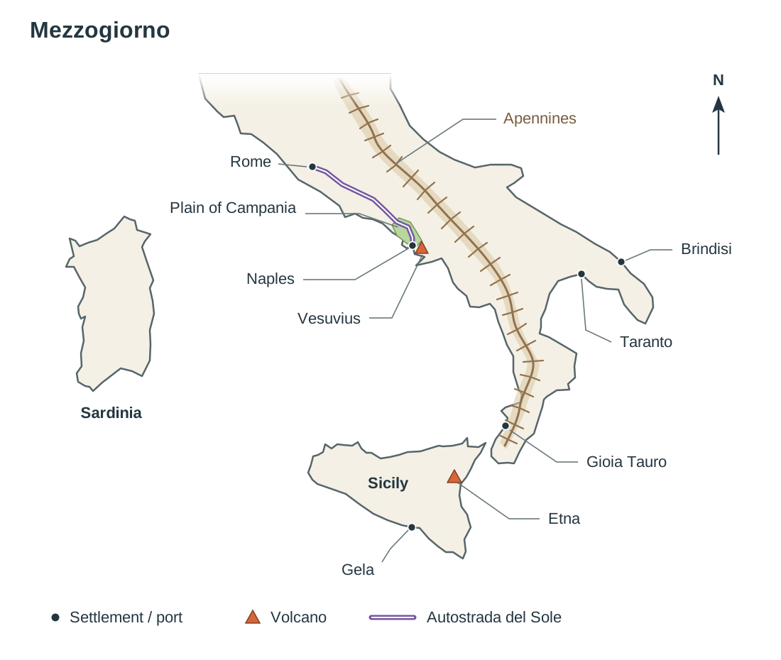
- Relief: Mountains and hills cover about 85% of the Mezzogiorno. The Apennines run down the centre of the peninsula like a spine, rising to 2,912 metres at Corno Grande. Active volcanoes (Mount Vesuvius, Mount Etna) and earthquake fault lines bring regular hazards. Flat land is scarce, restricted to narrow coastal strips like the Plain of Campania and the Metapontino.
- Drainage: Rivers like the Volturno and Agri flow down steep upland valleys. High summer heat and porous limestone dry out riverbeds for months, while winter cloudbursts trigger flash floods and soil wash on bare slopes.
- Climate: A Mediterranean climate dominates. Summer temperatures regularly climb past 25°C under the Azores High, causing high evaporation. The Sirocco, a hot, dust-laden wind blowing from the Sahara Desert, dries the soil and damages delicate blossoms. Winters are mild (averaging 9°C) and bring 600 mm to 800 mm of rain in heavy showers.
- Soils: Upland slopes have thin, eroded limestone soils. Rich volcanic ash soils surround Mount Vesuvius and the Plain of Campania. In Puglia and parts of Sicily, limestone weathering produces iron-rich, reddish clay soils known as terra rossa.
Sketch Map: The Mezzogiorno
To sketch this region: draw the southern boot of Italy south of Rome, including Sicily and Sardinia. Draw the Apennine mountain spine down the centre of the peninsula. Mark Naples, Mount Vesuvius, and the Plain of Campania on the west coast. Mark the industrial ports of Taranto and Brindisi on the south-east coast. On Sicily, mark Mount Etna and the petrochemical port of Gela. Add the container port of Gioia Tauro in Calabria, and trace the Autostrada del Sole running north from Naples towards Rome.
Primary Economic Activities
- Historical obstacles: Until 1950, farming was held back by an unequal land tenure system. Wealthy absentee landlords held vast, neglected estates (latifundia). They rented out tiny plots (minifundia) of 3 to 5 hectares to landless peasants (braccianti), who had to pay up to 60% of their crop yields in rent.
- The Cassa per il Mezzogiorno (1950–1984): The Italian government created this development agency to modernise the south. It broke up large estates and redistributed over 10% of regional farmland to roughly 100,000 tenant families, creating viable holdings of 5 to 50 hectares. The Cassa drained malarial marshes on the Metapontino plain and built irrigation networks covering over one million hectares.
- Modern output: Today, irrigated coastal plains produce valuable cash crops. Sicily grows nearly two-thirds of Italy's citrus fruit, Campania produces tomatoes on volcanic soils, and Puglia is a leading exporter of olive oil. The dry uplands remain restricted to extensive sheep and goat grazing.
Mezzogiorno: secondary, tertiary, and human processes
Industrial development and service provision in southern Italy have faced severe geographic and economic barriers.
Secondary Economic Activities
Manufacturing has been held back by long distances to wealthy northern markets (over 1,100 km), energy deficits, and a lack of surface water to cool machinery. In the 1950s, government planners chose coastal ports like Naples, Bari, and Taranto as industrial growth poles. State-owned firms were legally required to direct 60% of their new industrial investments to the south.
Major developments followed, including the Finsider steelworks built at Taranto in 1964, which turned the city into a major commercial port handling 35 million tonnes of cargo a year. Refineries and petrochemical plants were built at deep-water ports like Gela and Augusta in Sicily.
These state-backed plants became known as cathedrals in the desert. They were capital-intensive rather than labour-intensive, costing billions in subsidies while generating relatively few direct jobs. Because they imported raw materials by sea and shipped unfinished products north, they failed to create local component suppliers or spin-off businesses. When world steel and chemical markets slumped in the 1980s, these plants downsized, leaving regional unemployment above 20%.
Tertiary Economic Activities
Services employ about two-thirds of the southern workforce, though jobs are concentrated in public administration and seasonal tourism.
- Transport infrastructure: The Cassa invested heavily in transport links, most notably the 754 km Autostrada del Sole (A1 motorway), completed in 1964. This motorway connected Naples to Rome and Milan, allowing southern farmers to get fresh fruit and vegetables to northern cities quickly. Modern container ports were built at Gioia Tauro in Calabria.
- Tourism: Over 17 million tourists visit each year, attracted by the sunny climate, the Amalfi Coast, Pompeii, and Mount Vesuvius. Even so, only about 13% of foreign tourists in Italy travel south of Rome. Tourism remains seasonal, concentrates wealth along narrow coastal strips, inflates local housing prices, and puts heavy strain on local water supplies during dry summers.
Human Processes and Emigration
Between 1951 and 1971, roughly four million people left the Mezzogiorno. Most were young adults aged 18 to 30 heading for factory work in northern industrial cities like Milan and Turin, or moving abroad to Germany and the USA. This ongoing brain drain emptied out interior mountain villages. To stop their communities from disappearing, towns like Mussomeli and Sambuca di Sicilia have sold derelict houses for €1 to attract new residents.
The population is predominantly Roman Catholic. Standard Italian is taught in schools, but regional dialects like Neapolitan and Sicilian remain part of daily life, along with small language pockets of Arbëresh (Albanian) and Griko (Greek) in Calabria and Puglia.
Contrasting the two regions
When an exam question asks you to contrast or compare two European regions, write paired sentences. Address the core and the periphery together using comparative terms like in contrast or whereas. If you describe the Paris Basin in one block and the Mezzogiorno in another without linking them, you will lose comparison marks.
| Factor | Paris Basin (Core) | Mezzogiorno (Periphery) |
|---|---|---|
| Relief | Gentle sedimentary basin; over 80% is below 200 m, making mechanisation easy. | Over 85% is mountain and hill (Apennine spine); arable farming is confined to narrow coastal strips. |
| Climate | Cool temperate oceanic; steady rain all year round, giving a dependable growing season. | Mediterranean; summer droughts under the Azores High, worsened by the hot Sirocco wind. |
| Soils | Deep, stone-free limon (loess) and fertile river alluvium. | Thin, eroded limestone soils and terra rossa; fertile volcanic ash is restricted to Mount Vesuvius and Etna. |
| Farming | Large commercial cereal farms in Beauce, dairying in Brie, and vineyards in Champagne. | Irrigated citrus, olives, and tomatoes on coastal plains; sheep and goat grazing in the uplands. |
| Manufacturing | High-tech clusters and light industry: Cosmetic Valley, car plants on the Seine, 40% of national R&D. | State-planned heavy industry (Taranto steel, Gela petrochemicals) that became 'cathedrals in the desert'. |
| Services | Global financial and tourism hub; La Défense, TGV network, Charles de Gaulle Airport. | Seasonal tourism and public sector work; only 13% of foreign tourists in Italy go south of Rome. |
| Population | Steady in-migration, high densities, focused on the primate city of Paris. | Persistent out-migration to northern cities and abroad, leaving an ageing upland population. |
Sample paired sentence for your exam: 'The deep, stone-free limon soils of the Beauce plain allow farmers to produce record cereal yields on large, mechanised holdings, whereas thin, stony limestone soils on steep Apennine slopes restrict southern Italian farmers to grazing sheep and goats.'
The European Union: cohesion policy, enlargement, and challenges
European regions change constantly as political boundaries shift, economies integrate, and new states join the European Union.
How the EU Tries to Reduce Regional Inequality
EU cohesion policy transfers financial support from wealthy regions to poorer areas. Any region where GDP per capita sits below 75% of the EU average qualifies as a 'less developed region', making it eligible for the highest rate of structural funding. Southern Italy received substantial help under this rule, as did the Border, Midland and Western (BMW) region of Ireland in the past.
- European Regional Development Fund (ERDF): Finances roads, ports, broadband, and green energy, while supporting small businesses to attract private investment.
- European Social Fund (ESF): Funds job training, education schemes, and youth employment projects.
- Cohesion Fund: Finances environmental schemes and transport networks in member states whose Gross National Income per capita is below 90% of the EU average.
- Common Agricultural Policy (CAP): Takes up roughly a third of the total EU budget. It supports farm incomes through direct payments and rural development schemes. When the EU ended milk quotas in 2015, production caps disappeared, allowing dairy farmers in pasture-rich countries like Ireland to expand their herds.
Challenges Facing the European Union
In a 30-mark exam question on this topic, divide your answer evenly between the areas specified in the prompt. Questions often ask you to balance social and economic challenges, or focus on political union, economic union, and sovereignty, and the same balancing rule applies.
Social Challenges:
- Managing migration: The EU has open internal borders through the Schengen Agreement but lacks a single, agreed asylum system. Southern frontline states like Italy and Greece argue that the Dublin Regulation, which requires asylum claims to be handled in the country of first arrival, places an unfair burden on them. Disagreements over refugee quotas have led several countries to temporarily bring back internal border checks.
- An ageing population: Most member states have fertility rates well below the replacement level of 2.1 children per woman, while life expectancy keeps climbing. A rising dependency ratio strains national healthcare, hospital budgets, and pensions, while creating labour shortages in building, farming, and elder care.
- Housing shortages: Fast-growing capital cities across the EU, including Dublin, Paris, and Amsterdam, face severe housing shortages that drive up rents and house prices.
- Social integration: Integrating large numbers of new arrivals while respecting secular laws has sparked political debate, contributing to the rise of Eurosceptic political parties.
Economic Challenges:
- Regional wealth gaps: Deep economic divides persist between core regions (Île-de-France, Hamburg) and southern or eastern peripheries (the Mezzogiorno, rural Greece). High youth unemployment in the south encourages skilled young people to move north.
- Brexit: The United Kingdom formally left the EU in January 2020. This removed a major net contributor to the EU budget and introduced customs red tape on trade, hitting heavily exposed sectors like Irish agri-food and fishing.
- Energy costs and inflation: After the Russian invasion of Ukraine in 2022, EU countries cut their reliance on Russian pipeline gas, which caused electricity bills and industrial fuel costs to jump across Europe.
- Global competition: The EU faces tough manufacturing competition from the USA and China in green technology, electric vehicles, and semiconductors, where higher European energy and labour costs make competing difficult.
Enlargement, Sovereignty, and Changing Borders
- Political union: Political union means member states agreeing common policies on foreign affairs, defence, immigration and taxation. This is hard because national interests differ: states disagreed over sharing asylum seekers after 2015, and neutral states such as Ireland are cautious about common defence commitments. Integration has advanced through treaties — the Maastricht Treaty (1992) created the European Union and paved the way for the euro, and the Lisbon Treaty (2009) streamlined decision-making and created a permanent President of the European Council — but each treaty must be ratified nationally, so referendums can delay or block change.
- Enlargement: The EU grew from six founding members in 1957 to 28 by 2013 (now 27 after Brexit). The 2004 expansion added ten countries, mostly from Central and Eastern Europe. This added 75 million people to the single market and shifted structural funding towards newer members. Current candidate countries include Ukraine, Moldova, and Western Balkan states like Albania and Montenegro.
- Sovereignty concerns: Joining the EU means member states hand over some independent decision-making (sovereignty) in trade, fishing quotas, and environmental rules. Eurozone members leave interest rates and currency policy to the European Central Bank in Frankfurt. During the post-2008 banking crisis, countries like Ireland and Greece had to accept strict budget cuts set by the EU and IMF in exchange for bailout money.
- Changing borders: Following World War II, Germany was split into democratic West Germany and communist East Germany, separated by the Berlin Wall from 1961. The wall fell in 1989, and Germany reunited on 3 October 1990. Despite decades of federal investment, wages and productivity in the eastern states still trail the west, showing that bridging economic gaps between reunited regions takes generations.
Key terms
- Core Region
- An economically prosperous, urbanised area with natural advantages and modern infrastructure that attracts capital investment and workers (for example, the Paris Basin).
- Peripheral Region
- An economically disadvantaged, distant area with poor infrastructure, lower average incomes, and net outward migration (for example, the Mezzogiorno).
- Limon
- A fertile, stone-free windblown silt deposited during glacial periods, found across the Beauce and Île-de-France plateaus.
- Terra Rossa
- A reddish, iron-rich clay soil formed by the chemical weathering of limestone bedrock in Mediterranean climates, found in parts of Puglia and Sicily.
- Cuesta
- An asymmetrical ridge formed by gently dipping sedimentary rock, with a steep scarp slope on one side and a gentle dip slope on the other.
- Primate City
- A city that is at least twice as large as the second-largest city in a country and dominates national political, economic, and cultural life.
- Cassa per il Mezzogiorno
- A state development fund set up by the Italian government in 1950 to modernise farming, build motorways, and establish industrial growth poles in southern Italy.
- Growth Pole
- A specific town or city chosen by economic planners to receive concentrated industrial and transport investment to stimulate regional development.
- Cathedrals in the Desert
- Large, capital-intensive heavy industrial plants (such as the Taranto steelworks) that cost huge sums of state money but generated few local jobs or spin-off businesses.
- Latifundia
- Vast, privately owned farming estates historically common in southern Italy, owned by absentee landlords and cultivated inefficiently by tenant farmers and day-labourers.
- Minifundia
- Small, uneconomic plots of land (often 3 to 5 hectares) rented out to peasant farmers in southern Italy, keeping families tied to subsistence farming.
- Braccianti
- Landless agricultural day-labourers in historical southern Italy who endured seasonal poverty and insecure working conditions.
- Sirocco
- A hot, dry, dust-laden wind blowing north from the Sahara Desert across the Mediterranean, drying out soils and scorching crops in southern Italy.
- Schéma Directeur
- The regional master plan approved in 1965 to curb urban sprawl in Paris by building five planned satellite new towns and suburban business nodes.
- Brain Drain
- The sustained emigration of educated, skilled young workers from economically depressed or peripheral regions to wealthier economic cores.
- Sovereignty
- The independent authority of a nation-state to govern itself, pass its own laws, and manage domestic and foreign policy without external control.
- Nodal Region
- An area organised around a central urban hub (the node) and its surrounding functional hinterland, tied together by transport and commuting routes.
- Hinterland
- The area surrounding an urban centre that relies on the city for jobs, retail, and commercial services, while supplying labour and food to the city.
- Significant Relevant Point
- A single, factual geographic statement, named example, statistic, or explained cause-and-effect relationship worth two marks in Leaving Certificate examination marking schemes.
Check yourself
What is limon, and why is it important to agriculture in the Paris Basin?
Limon is a fertile, stone-free, windblown silty dust deposited during glacial periods. It retains moisture and nutrients, enabling the flat Beauce plateau to achieve some of the highest cereal yields in the European Union.
Name two physical factors that create agricultural difficulties across the Mezzogiorno.
Steep, mountainous relief across 85% of the region (the Apennines), which prevents modern machinery from operating; and summer drought under the Azores High, intensified by the hot, drying Saharan Sirocco wind.
What were the primary goals of the French 'Schéma Directeur' plan approved in 1965?
To manage urban sprawl and congestion in Paris by constructing five planned satellite new towns (such as Marne-la-Vallée), building self-contained suburban business nodes (such as La Défense), and integrating them with the RER rail network.
Why were major manufacturing developments in the Mezzogiorno referred to as 'cathedrals in the desert'?
They were massive, capital-intensive state industrial plants (such as the Taranto steelworks) that cost huge sums of money but created few direct jobs and failed to establish local supply chains or spin-off industries in the surrounding peripheral economy.
State two purposes of the European Regional Development Fund (ERDF).
To finance major infrastructure projects (such as roads, ports, and broadband networks) and to attract inward investment and support small and medium enterprises to reduce economic imbalances between member regions.
What economic threshold qualifies an EU region for the highest rate of structural funding as a 'less developed region'?
Having a Gross Domestic Product (GDP) per capita below 75% of the European Union average.
Name one social challenge and one economic challenge currently facing the European Union.
A major social challenge is managing migration and harmonising asylum rules across member states under the Dublin Regulation; a major economic challenge is addressing regional inequality between wealthy core regions (like Île-de-France) and poorer peripheral regions (like the Mezzogiorno).