

For Leaving Certificate Higher Level Geography, Core Unit 2 requires the study of one continental or subcontinental region outside Europe. This topic uses Brazil to examine how physical processes (relief, drainage, climate, and soils) directly interact with economic processes (primary, secondary, and tertiary activities) and human processes (culture, language, religion, population dynamics, and urban growth). Higher Level answers earn marks through Significant Relevant Points (SRPs) containing specific named places, comparative statistics, and cause-and-effect explanations. Rather than presenting isolated facts, this note analyses the core–periphery divide between the South-East industrial core and the peripheral North-East and Amazon, explores cumulative causation, and evaluates state attempts to manage regional imbalance.
Continental Setting and Regional Framework
A region is an area of the Earth's surface defined by specific physical, economic, or human criteria operating at various scales. Brazil covers approximately 8.5 million km²—nearly half of South America and over 100 times the size of Ireland—making it a continental-scale study area stretching from roughly 5°N to 33°S.
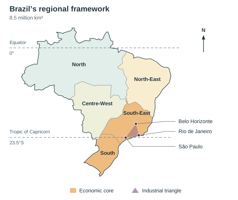
Locational Context and the 90-Second Regional Sketch Map
Because approximately 90% of Brazil lies between the equator and the Tropic of Capricorn, high temperatures persist throughout the year; rainfall distribution, rather than temperature, dictates agricultural seasons. Marking schemes routinely reward a relevant, labelled sketch map. When drawing Brazil in the examination, sketch a rough shield shape and label:
- Latitudes: The equator across the north (passing through Macapá and the Amazon mouth) and the Tropic of Capricorn across the south (running just north of São Paulo).
- The Four Primary Study Zones: The South-East and South (the economic core), the North (the Amazon Basin resource frontier), the North-East (the semi-arid Sertão periphery), and the Centre-West (the Cerrado commercial agricultural frontier).
- Relief and Drainage: The Brazilian Highlands with the steep Atlantic coastal escarpment, the Amazon lowlands, the Pantanal wetlands, the Amazon River and its major tributaries (Negro, Madeira, Tapajós, Xingu), the São Francisco River, and the Paraná River.
- Key Economic Nodes: The São Paulo–Rio de Janeiro–Belo Horizonte industrial triangle, the Port of Santos, the iron ore reserves of Carajás and the Iron Quadrangle, Brasília, Manaus, and the Trans-Amazonian Highway (BR-230).
Consistent Employment and Economic Profile
Keep your macroeconomic data consistent across answers:
- Primary activities: Employ approximately 9–10% of the workforce. However, agribusiness (farming, processing, and distribution) generates roughly 25% of national GDP and nearly half of Brazil's export earnings. Employment numbers are relatively low because commercial grain and soya farming are highly mechanised.
- Secondary activities: Employ roughly 20% of the labour force (manufacturing alone accounts for about 13%), generating approximately a fifth of national output.
- Tertiary activities: Employ approximately 70% of the workforce and generate over 60% of GDP, heavily concentrated in coastal metropolitan areas.
Physical Processes: Relief, Drainage, and Atmospheric Circulation
Brazil's physical environment is divided between elevated ancient plateaus and lowland sedimentary basins.
Relief Landscapes
- The Brazilian Highlands (Planalto Central): Covering over 50% of the country, this ancient eroded plateau averages 1,000 metres in elevation. Along the Atlantic coast, it terminates in a steep, rugged escarpment (the Serra do Mar) rising directly behind a narrow coastal plain. This escarpment formed a severe physical barrier that historically hindered transport construction and delayed settlement of the interior.
- The Guiana Highlands: A rugged upland region along Brazil's northern border containing the country's highest peak, Pico da Neblina (2,994 metres).
- Lowland Sedimentary Basins: The flat Amazon lowland basin covers about 40% of national territory, featuring seasonal river floodplains (várzea) extending up to 100 km wide alongside elevated, unflooded terrain (terra firme). Along the south-western border lies the Pantanal, one of the world's largest tropical freshwater wetlands.
Drainage Systems and Moisture Recycling
Brazil is dominated by the Amazon River system, which drains nearly 60% of the national territory (the Legal Amazon basin). Discharging approximately 20% of all fresh water entering the global oceans, its outflow pushes a plume of fresh, muddy water hundreds of kilometres into the Atlantic Ocean. Strong equatorial tides and marine currents disperse this sediment, meaning the river terminates in a broad marine estuary around Marajó Island rather than an emergent land delta.
Other major drainage systems include the Paraná-Paraguay in the south (providing immense hydroelectric power), the São Francisco in the North-East (supplying water to semi-arid landscapes), and the Tocantins-Araguaia system.
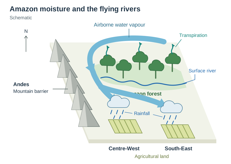
Atmospheric Feedback: The 'Flying Rivers'
Rainforest vegetation directly influences continental climate. Dense tree cover transpires massive quantities of water vapour into the atmosphere every day, forming airborne moisture corridors known as 'flying rivers'. Channeled southward by the Andes mountain barrier, this recycled moisture supplies a major share of the rainfall received by the agricultural core in the Centre-West and South-East. Consequently, deforestation in the northern Amazon directly threatens the rainfall and water security of commercial soya, coffee, and hydroelectric basins thousands of kilometres to the south.
Physical Processes: Climate Regimes and Soil Types
Rainfall seasonality and soil properties dictate regional agricultural capabilities across Brazil.
Climate Regimes
- Equatorial (Amazon Basin): Characterised by constant high temperatures averaging 27°C with minimal seasonal variation. Convectional rainfall exceeds 2,000 mm annually, driven by the Intertropical Convergence Zone (ITCZ).
- Tropical Wet-Dry Savanna (Cerrado / Central Plateau): Average temperatures hover around 20–24°C, dropping during winter due to altitude. Rainfall averages 1,000–1,800 mm, concentrated heavily in the southern-hemisphere summer months (November to April). A pronounced dry season occurs during the winter months (May to October).
- Semi-Arid (North-East Sertão): Average temperatures reach 29°C, with daytime maximums regularly exceeding 38°C. Annual rainfall is erratic, ranging between 350 mm and 750 mm, and severe drought cycles return roughly every seven years.
Soil Characteristics and Agricultural Suitability
| Soil | Where it is found | What it is like | What it can grow |
|---|---|---|---|
| Ferralsols (Latosols / Tropical Red Soils) | Amazon Basin and Cerrado savanna | Deep, heavily leached, red/yellow soils; so acidic that aluminium damages plant roots; short of natural phosphorus. | Low natural fertility once forest is cleared. In the Cerrado, they become highly productive only after applying industrial lime to correct acidity and phosphate fertilisers. |
| Terra Roxa | South-East (São Paulo and Paraná) | Deep, dark red, fertile soil weathered from volcanic basalt bedrock; rich in minerals and humus. | Exceptionally high fertility; forms the backbone of commercial coffee, citrus, and sugarcane estates. |
| Alluvial Soils | River floodplains (várzea) | Nutrient-rich silts deposited by seasonal river inundations. | Naturally fertile; highly productive for intensive local food cropping. |
| Sertão Soils | North-East interior | Shallow, stony, dry soils with minimal organic humus accumulation. | Extremely poor; supports only drought-resistant caatinga scrub and low-density livestock grazing. |
Note on terminology: Both spellings, terra roxa and terra rossa, appear in Leaving Certificate textbooks for the basalt-derived soils of the South-East. Use one consistently and describe its characteristics (deep, dark red, weathered from basalt, highly fertile). When tropical ferralsols lose their forest canopy, rainfall leaches away soluble minerals, and direct equatorial sunlight bakes the iron-rich topsoil into a rock-hard, unworkable crust called laterite.
Primary Economic Activities: Agriculture, Forestry, Fishing, Mining, and Energy
Primary activities supply domestic industries and generate nearly half of Brazil's export income.
Commercial Agriculture and the Cerrado Revolution
Brazil is a leading global exporter of soybeans, sugarcane, coffee, beef, and orange juice. In the interior savannas of Mato Grosso and Goiás, commercial soya cultivation expanded rapidly after the state research agency, EMBRAPA, developed techniques to correct acidic ferralsols using ground agricultural limestone and fertilisers. Flat plateau relief allows massive combine harvesters to operate efficiently. The rainy summer (November to April) waters the crop, while the dry winter allows harvesting and transport to port without crop spoilage. In São Paulo, commercial plantations cultivate sugarcane to supply domestic food processors and bioethanol distilleries.
Subsistence Farming and Irrigation in the Periphery
In the North-East Sertão, rural smallholders depend on rain-fed plots of maize, beans, and cassava. Frequent droughts cause widespread crop failures, driving rural debt and outward migration. However, public irrigation schemes along the São Francisco River around Petrolina and Juazeiro have transformed dry scrubland into fertile commercial vineyards and mango orchards, producing premium fruit for European export.
Forestry: Plantations versus Deforestation
Alongside native forest clearance, Brazil has built the world's most productive commercial plantation forestry sector, covering roughly 10 million hectares of eucalyptus and pine in São Paulo, Minas Gerais, Paraná, and Bahia. Year-round warmth and over 1,200 mm of rain allow eucalyptus trees to mature in just 6–7 years (compared to 30–40 years for conifers in Ireland). The harvested wood feeds massive export mills operated by domestic corporations such as Suzano, making Brazil the global leader in bleached eucalyptus market pulp. In contrast, logging of native hardwoods like mahogany in Pará is frequently illegal and acts as the spearhead for pasture clearance.
Fishing and Aquaculture
Brazil has a 7,500 km coastline, but its marine catch is modest (700,000–800,000 tonnes annually) because the tropical South Atlantic has a narrow continental shelf, warm water, and no cold upwelling currents. The leading ocean fishing grounds lie off the colder southern coast, centered on the landing port of Itajaí (Santa Catarina). In the interior, the Amazon river fishery supplies vital subsistence protein (species like tambaqui and pirarucu) to river communities and the city of Manaus. Meanwhile, commercial freshwater aquaculture is expanding rapidly, with tilapia raised in hydroelectric reservoirs in Paraná and commercial shrimp farms built along the North-East coastline.
Mining and Energy Infrastructure
- Mining: The open-cast mine at Carajás (Pará) holds the world's largest deposits of high-grade iron ore. Mined ore is transported via a dedicated 900 km railway to the deep-water port of Ponta da Madeira in São Luís for export to Asian and European markets. The historic Iron Quadrangle in Minas Gerais extracts hematite iron ore and bauxite to feed domestic industries.
- Hydroelectric Power (HEP): Generates over 60% of national electricity. The Itaipu Dam on the Paraná River (jointly operated with Paraguay) supplies heavy manufacturing in the South-East, while the Belo Monte Dam on the Xingu River powers northern mining hubs.
- Sugarcane Bioethanol (Proálcool): Launched in 1975, the Proálcool programme subsidised ethanol distilled from sugarcane grown in São Paulo. Used in domestic vehicles, it cut petroleum imports and pioneered flex-fuel technology.
- Offshore Oil: Petrobras extracts crude from deep-water 'pre-salt' reservoirs in the Campos and Santos basins off Rio de Janeiro. These deposits lie 5–7 km below sea level (under 2 km of ocean, rock, and a 2 km salt crust), requiring advanced deep-sea drilling technologies.
- Wind Energy: Strong, consistent trade winds along the North-East coast make Bahia, Ceará, and Rio Grande do Norte the center of Brazilian wind generation. Wind output peaks during the dry season, supplying renewable power to the South-East when hydro reservoirs are low.
Secondary Economic Activities: The South-East Industrial Core and Regional Decentralisation
Manufacturing generates approximately one-fifth of Brazil's output and employs roughly 13% of the labour force directly.
Historical Foundations and Import Substitution
Before the 1940s, Brazil operated as a primary commodity exporter, relying on coffee, sugar, and cotton. Transatlantic shipping disruptions during World War II cut off imported manufactured products, forcing the federal government to implement import substitution industrialisation. In the 1940s, the state established the National Steel Company at Volta Redonda (Rio de Janeiro state), creating a heavy metallurgical base that supplied domestic shipbuilders, rail lines, and construction firms.
Core Manufacturing Sectors
- Iron and Steel: Brazil produces approximately 35 million tonnes of crude steel annually across modern mills in Minas Gerais and Rio de Janeiro, using local iron ore from the Iron Quadrangle and domestic limestone.
- Automotive Industry: Brazil assembles over two million vehicles annually—peaking near three million—making it South America's dominant automotive manufacturer. Assembly expanded after Brazil became a founding member of Mercosur in 1991 (alongside Argentina, Uruguay, and Paraguay), which eliminated regional tariffs. Multinational corporations, including Fiat at Betim (Minas Gerais) and Volkswagen in São Paulo, established large-scale assembly operations. To cut oil consumption and meet national PROCONVE emission standards, engineers developed flex-fuel engines, which run on petrol, bioethanol, or any blend of the two.
- Food Processing and Consumer Goods: Brazil's agricultural output supplies extensive food-processing facilities, drawing investment from multinational firms like Nestlé and Unilever. High domestic clothing demand supports an integrated textile and garment sector employing over 1.5 million people.
Geographic Concentration and Cumulative Causation
Over 80% of Brazilian secondary manufacturing is concentrated within the São Paulo–Rio de Janeiro–Belo Horizonte triangle due to five converging factors:
- Raw Materials: Direct rail access to iron ore and bauxite from the Iron Quadrangle.
- Energy: Abundant power from Paraná river hydroelectric schemes and offshore Campos Basin petroleum.
- Consumer Market and Labour: Over 40 million urban residents provide both a skilled workforce and concentrated consumer purchasing power.
- Transport Hubs: Modern road corridors link assembly plants to the Port of Santos, Latin America's busiest container terminal, which handles 28% of all national export trade.
- Cumulative Causation: 19th-century coffee profits financed early railways, municipal utilities, banks, and universities in São Paulo. This early infrastructure attracted specialized component suppliers and engineering firms, creating a self-reinforcing industrial agglomeration.
Tertiary Economic Activities: Transport Challenges and Tourism Development
The service sector employs approximately 70% of Brazil's workforce and generates the majority of national wealth, though infrastructure remains heavily concentrated in coastal states.
Continental Transport Networks
Developing transport routes across Brazil involves navigating formidable physical barriers:
- Roadways: Roads handle more than 60% of all national freight. The South-East contains multi-lane motorways, while interior routes are frequently unpaved. The 4,000 km Trans-Amazonian Highway (BR-230) was built in the 1970s to connect drought-hit north-eastern migrants to land and mineral extraction in the Amazon, but heavy equatorial rainfall regularly washes away unpaved sections.
- Railways: Rail is almost entirely dedicated to bulk export commodities (such as Carajás iron ore to Ponta da Madeira port, or grain trains from the Cerrado to Santos). Commuter passenger rail is limited to major urban centers; São Paulo's metro and commuter rail network carries several million passengers daily to relieve severe surface road congestion.
- Ports and River Barges: Maritime ports handle over 90% of national export cargo, with the Port of Santos serving as the primary logistics hub for São Paulo's industrial belt. In the roadless Amazon, navigable rivers remain the only practical freight corridors. The interior city of Manaus, situated 1,500 km upstream, uses container barges on the Amazon River and international air freight to export electronics and motorcycles assembled in its free trade zone.
Tourism Sectors
Tourism generates over 6% of national GDP and supports millions of domestic jobs:
- Coastal Tourism: Brazil's warm tropical coastline attracts millions of domestic holidaymakers and international tourists to urban resort beaches like Copacabana and Ipanema in Rio de Janeiro.
- Cultural Heritage and Celebrations: The annual Rio de Janeiro Carnival draws over two million street revellers each day, generating substantial seasonal hospitality revenue and supporting 250,000 service jobs. Colonial towns like Salvador and Olinda attract cultural tourism with their preserved Portuguese architecture.
- Ecotourism: The Pantanal wetlands and the Amazon rainforest support wildlife-watching and river cruises. Ecotourism generates sustainable revenue for local guides and river communities, offering an economic alternative to cattle ranching and deforestation.
Human Processes: Language, Religion, and Cultural Expression
Brazil's human landscape reflects the interaction between Indigenous peoples, Portuguese colonisers, and roughly 4.5 million enslaved Africans transported between the 16th and 19th centuries—more than to any other country—primarily to work the sugar estates of the North-East and later the coffee plantations of the South-East.
Language and National Identity
- Portuguese: Brazil is the sole Portuguese-speaking nation in the Americas, spoken by over 99% of its 203 million people. Brazilian Portuguese incorporates hundreds of loanwords from Indigenous Tupi-Guarani and African Bantu languages, visible across regional place names (e.g., Maranhão, Ipanema).
- Indigenous Languages: Around 150–180 Indigenous languages survive among a few hundred thousand people, primarily within legally demarcated Indigenous territories in the Amazon interior and along the Paraguayan border. Linguistic survival is tied to the defense of ancestral land boundaries against illegal miners and loggers.
Religious Patterns and Syncretism
- Roman Catholicism: Introduced by Portuguese Jesuit missionaries, Catholicism became the official state religion in 1824. Brazil has the largest Catholic population globally (roughly 55–60% identifying as Catholic in recent census returns). However, active weekly attendance is near 20%, showing that Catholicism functions largely as cultural heritage and family tradition.
- Evangelical Christianity: Rapidly growing across urban working-class districts and favelas, now comprising roughly 30% of the population.
- Religious Syncretism: Enslaved Africans in colonial plantations preserved their ancestral spiritual beliefs by masking Yoruba deities behind the identities of Catholic saints. This syncretism produced uniquely Brazilian faiths such as Candomblé and Umbanda, which remain cultural anchors in North-Eastern cities like Salvador, Bahia.
Cultural Unity: Music and Sport
Samba music evolved from Afro-Brazilian drum rhythms in Bahia and Rio de Janeiro, becoming the defining sound of national Carnival celebrations. Association football acts as a powerful unifying cultural force across socio-economic and racial divides, reinforced by five FIFA World Cup titles and sporting icons such as Pelé.
Human Processes: Population Dynamics, Urbanisation, and Regional Imbalance
Brazil's population of 203 million (2022 Census) is heavily concentrated, with over 80% living within 200 km of the Atlantic coastline.
Demographic Transition
Brazil's total fertility rate dropped dramatically from 6.0 children per woman in 1960 to approximately 1.6 in 2022—well below the replacement level of 2.1. Rapid urbanisation, increased female educational and employment attainment, and high urban living costs drove this shift. Consequently, Brazil's population growth has slowed, and the country is entering an ageing demographic phase that will increase dependency ratios and place financial strain on national pension and healthcare systems.
Rural-to-Urban Migration and Over-Urbanisation
Over 85% of Brazilians live in urban settlements. Rapid rural-urban migration from the 1960s onward was driven by powerful push and pull factors:
- Push Factors: Recurrent droughts in the North-East Sertão, rural poverty, highly unequal land distribution, and the mechanisation of commercial soya and cattle estates in the interior, which eliminated agricultural jobs.
- Pull Factors: Expanding factory, construction, and informal service jobs in the South-East industrial triangle, alongside superior medical and educational facilities.
More migrants arrived than municipal authorities could house or service. This process is called over-urbanisation: urban population growth outpaces the supply of formal housing, piped water, sewerage, and paved roads. New arrivals settled on vacant, marginal land, forming informal settlements known as favelas:
- Favelas (such as Rocinha in Rio de Janeiro) developed on steep, landslide-prone granite slopes without civil infrastructure.
- Residents endure inadequate sanitation, irregular water supply, and risks of devastating mudslides during intense summer rainfall.
- Municipal strategies have shifted from forced clearances toward upgrading initiatives (such as the Favela-Bairro project), installing retaining walls, stormwater drainage, paved access roads, and legal land tenure.
Government Policies to Reduce Regional Imbalance
- Construction of Brasília (1960): The federal government built a new planned capital on the Central Plateau to shift administrative power away from coastal Rio de Janeiro, stimulate infrastructure into the interior, and open the Centre-West.
- SUDENE (1959): The Superintendency for the Development of the North-East used tax incentives and capital grants to attract manufacturing to the impoverished periphery. However, most investment clustered in coastal state capitals (Salvador, Recife, Fortaleza) rather than the interior Sertão, widening coastal-interior disparities within the periphery.
- Industrial Decentralisation: State incentives attracted car assembly and petrochemical complexes to the North-East, including the Fiat-Stellantis plant at Goiana (Pernambuco) and the port complex at Suape near Recife.
- Manaus Free Trade Zone (1967): To stimulate investment in the isolated Amazon basin, the federal government granted tax exemptions to firms assembling electronics and consumer goods in Manaus.
- Social Welfare Transfers: The Bolsa Família conditional cash-transfer programme reached over 13 million low-income households. Because poverty is concentrated in the North-East, these cash payments boosted local retail demand and helped reduce rural out-migration.
Regional Complexity: Core-Periphery Contrasts and Changing Boundaries
At Higher Level, students must assess the complexity of regional interactions and explain how boundaries and economic roles shift over time.
Measuring the Core–Periphery Divide
Regional inequalities in Brazil illustrate the classic core–periphery model. The South-East core generates wealth through high-value manufacturing and financial services, while peripheral regions supply raw commodities, energy, and low-cost migrant labour.
| Region | Share of population | Share of national GDP | Share of land area |
|---|---|---|---|
| South-East (Core) | approx. 42% | approx. 53% | approx. 11% |
| South | approx. 14% | approx. 17% | approx. 7% |
| North-East (Periphery) | approx. 27% | approx. 14% | approx. 18% |
| North (Amazon) | approx. 9% | approx. 6% | approx. 45% |
| Centre-West | approx. 8% | approx. 10% | approx. 19% |
Socio-economic indicators highlight this divide:
- GDP per person in São Paulo state is approximately three times higher than in peripheral Maranhão or Piauí.
- Adult illiteracy is roughly 11–12% in the North-East compared with approximately 3% in the South-East.
- Life expectancy is about five years lower in the North-East (approx. 72–73 years) than in the South-East (approx. 77–78 years).
Changing Regional Boundaries: Frontiers in Motion
Regional limits are dynamic rather than fixed:
- The MATOPIBA Agricultural Frontier: The boundary of commercial grain cultivation is advancing across the MATOPIBA region (encompassing parts of Maranhão, Tocantins, Piauí, and Bahia). Cheap savanna land on the border between the Centre-West and North-East is being cleared for commercial soya, absorbing parts of the traditional periphery into the modern agribusiness core.
- The Arc of Deforestation: The border between native tropical rainforest and commercial cattle pasture in the southern Amazon basin has pushed northward along arterial highways like the BR-163 and BR-230.
- Technological Transformation of the Semi-Arid Zone: Irrigation infrastructure along the São Francisco River has turned formerly unproductive caatinga scrub around Petrolina into an export-oriented commercial fruit corridor.
Key terms
- Continental/Subcontinental Region
- A large-scale geographical area studied outside Europe (such as Brazil) to assess the complex interaction of physical, economic, and human processes.
- Brazilian Highlands
- An extensive ancient plateau covering over half of Brazil, characterised by rolling terrain, rich mineral deposits, and a steep Atlantic coastal escarpment.
- Terra Firme
- Elevated, unflooded land in the Amazon Basin situated above annual river flood levels, contrasting with seasonal floodplains (várzea).
- Várzea
- Low-lying river floodplains in the Amazon Basin that are seasonally submerged and enriched with fertile alluvial sediment deposits.
- Sertão
- The dry, semi-arid interior of North-Eastern Brazil, characterised by shallow soils, recurrent cyclical droughts, and caatinga scrub.
- Caatinga
- Drought-resistant, thorny scrub and cactus vegetation native to the semi-arid North-East Sertão of Brazil.
- Ferralsols
- Deep, heavily weathered, acidic tropical red soils (latosols) with high aluminium toxicity, naturally reliant on forest canopy leaf litter for nutrients.
- Laterite
- A hard, brick-like, infertile crust formed when cleared tropical red soils are leached by torrential rain and baked by intense equatorial sunshine.
- Terra Roxa
- A highly fertile, dark red soil weathered from volcanic basalt bedrock in São Paulo and Paraná, foundational to Brazil's coffee and sugarcane production.
- Cerrado
- The extensive tropical savanna plateau of central Brazil, transformed into a commercial soya and grain belt following agricultural liming.
- EMBRAPA
- The Brazilian Agricultural Research Corporation, a state agency that developed soil-liming techniques and adapted crop varieties for tropical savanna farming.
- Flying Rivers
- Massive air currents carrying water vapour transpired by the Amazon rainforest southward toward the Centre-West and South-East agricultural basins.
- Cumulative Causation
- The self-reinforcing process where an initial economic advantage (such as coffee wealth in São Paulo) continuously attracts infrastructure, capital, and skilled labour.
- Core–Periphery Model
- A spatial model contrasting an economically dominant, capital-rich core (South-East Brazil) with an underdeveloped, resource-supplying periphery (North-East/Amazon).
- Over-Urbanisation
- Urban population growth that severely outpaces the municipal capacity to supply employment, formal housing, sewerage, clean water, and transport.
- Favela
- An unplanned, densely populated informal settlement in a Brazilian urban area, typically built on steep hillsides or marshy floodplains without municipal services.
- Religious Syncretism
- The blending of differing religious traditions, such as the fusion of West African spiritual deities with Roman Catholic saints in Candomblé and Umbanda.
- Mercosur
- A South American trade bloc founded in 1991 by Brazil, Argentina, Uruguay, and Paraguay to eliminate regional tariffs and stimulate economic integration.
- Flex-Fuel Engine
- An engine technology pioneered in Brazil capable of running on petrol, sugarcane bioethanol, or any blend of the two.
- SUDENE
- The Superintendency for the Development of the North-East, a state agency established in 1959 to coordinate industrial grants and tax relief for the periphery.
Check yourself
Roughly what proportion of Brazil's total national territory is drained by the Amazon River network?
Close to 60% of the national territory.
Name the three major metropolitan cities that form Brazil's South-East Industrial Triangle.
São Paulo, Rio de Janeiro, and Belo Horizonte.
What is laterite, and under what conditions does it develop?
Laterite is a hard, brick-like, infertile crust formed when cleared tropical red soils are leached of soluble minerals by heavy rainfall and baked by intense equatorial sun.
How did EMBRAPA enable commercial soya farming across the acidic Cerrado savannas?
EMBRAPA introduced widespread agricultural liming to neutralise soil acidity and eliminate aluminium toxicity, combined with phosphate fertilisers and adapted crop strains.
Give three factors explaining why over 80% of Brazilian manufacturing is in the South-East, and explain one fully.
Factors: raw materials from the Iron Quadrangle, energy from Itaipu HEP and offshore oil, a wealthy consumer market, skilled labour, and the Port of Santos. Full explanation: Cumulative causation meant early 19th-century coffee profits funded railways, utilities, and banks in São Paulo, which later attracted component manufacturers, universities, and industrial capital.
The Cerrado rainy season runs from November to April. Why is this timing advantageous for the commercial soya harvest?
Rain falls during the southern-hemisphere summer to support crop growth, while the dry winter season (May to October) allows farmers to harvest soya and transport it over unpaved roads to ports without crop spoilage.
What does religious syncretism mean in Brazilian culture, and what faith exemplifies it?
Religious syncretism is the blending of differing religious beliefs. In Brazil, enslaved Africans preserved their spiritual traditions by disguising Yoruba deities as Catholic saints, creating faiths such as Candomblé and Umbanda.
What is the new commercial grain frontier developing across parts of Maranhão, Tocantins, Piauí, and Bahia called?
The MATOPIBA agricultural frontier.