

Plate tectonics is the foundational model explaining how the Earth's surface moves and evolves. The Earth's rigid outer shell (the lithosphere) is broken into large pieces called plates, which move at a rate of a few centimetres each year across the softer, slowly churning mantle below (the asthenosphere). Plate movement is driven by heat escaping from deep inside the Earth through mantle convection. Interactions along plate margins generate endogenic forces that build up the landscape through volcanism, earthquakes, folding, and faulting, while surface exogenic forces gradually wear these structures down. These tectonic mechanisms have shaped the global distribution of mountains and ocean basins, and they have repeatedly reshaped Ireland's geology over hundreds of millions of years.
Earth Structure, Mantle Convection, and Endogenic Forces
To understand plate tectonics, we must distinguish between internal and external forces acting on the crust:
- Endogenic forces: Forces that originate within the Earth, driven by internal geothermal energy. They build up relief features through plate movement, volcanism, earthquakes, crustal folding, and faulting (e.g. the uplift of the Himalayas or the Munster fold ridges).
- Exogenic forces: External forces that act on the surface to break down and wear away the landscape, including weathering and erosion by rivers, ice, the sea, and wind.
Landforms reflect a continuous balance over time between these endogenic constructional forces and exogenic destructional forces.
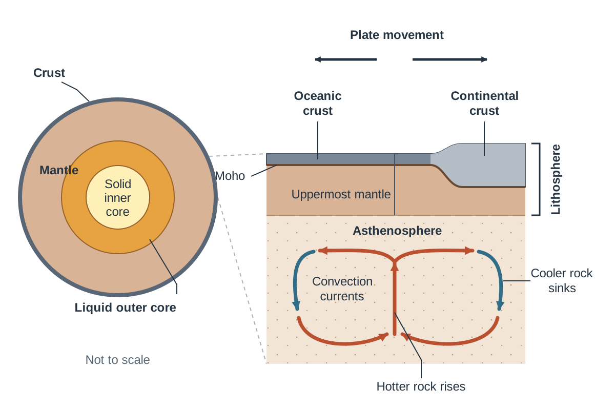
The Layers of the Earth
- Crust: The solid, brittle outer skin of the Earth. It comes in two types:
- Continental crust: 30 km to 70 km thick, composed mainly of lighter granitic rock rich in silica and alumina (sial).
- Oceanic crust: 3 km to 10 km thick, composed of heavier, denser basaltic rock rich in silica and magnesium (sima). Because oceanic crust is denser, it always subducts beneath continental crust during collisions.
- Mohorovičić discontinuity (Moho): The sharp geological boundary separating the crust from the denser mantle beneath.
- Lithosphere: The rigid mechanical layer formed by the entire crust together with the solid uppermost section of the mantle. The lithosphere is broken into tectonic plates.
- Asthenosphere: The upper mantle layer directly below the lithosphere (100 km to 200 km deep). High temperatures and pressures keep this rock semi-molten and capable of flowing extremely slowly.
- Core: The metallic centre of the Earth, rich in iron and nickel. It is divided into a liquid outer core, which circulates to generate Earth's magnetic field, and a solid inner core where temperatures exceed 4,000 °C but immense pressure prevents melting.
The Convection Driving Mechanism
Heat escaping from the core and radioactive decay warms deep mantle rock. As this rock warms, it expands, becomes less dense, and slowly rises towards the crust. Reaching the upper mantle, it cools, turns horizontally, and drags the overlying tectonic plates with it before sinking back down. This continuous circular motion forms a convection current. Where convection currents move apart beneath the crust, plates diverge; where they turn downwards together, plates converge.
Development of the Plate Tectonics Model
Our modern understanding developed through four key scientific stages:
1. Alfred Wegener and Continental Drift (1912)
Wegener proposed that roughly 200 million years ago all continents were united in a single supercontinent called Pangaea. Over geological time, Pangaea broke into two landmasses—Laurasia in the north and Gondwanaland in the south—before fragmenting into our modern continents. He supported this with four observations:
- Jigsaw fit: Continental coastlines match across oceans, especially visible when aligning the continental shelves of South America and Africa.
- Fossil evidence: Identical fossils of the freshwater reptile Mesosaurus occur in South America and southern Africa; this creature could not have crossed an open ocean. The fossil fern Glossopteris is found across India, Australia, South America, and Antarctica.
- Matching mountain belts: Rock strata and fold structures in the Appalachian Mountains of North America line up directly with the Caledonian belts of Ireland, Scotland, and Scandinavia.
- Ancient glaciation: Fossil glacial moraines and rock scratches (striations) from the same era occur across tropical zones in India, Australia, and southern Africa, proving these landmasses once sat clustered near the South Pole.
Wegener's theory was rejected because he could not prove a physical mechanism strong enough to plough solid continents across oceanic rock.
2. Arthur Holmes and Convection (1928)
Holmes proposed the missing mechanism: thermal convection currents churning within the mantle drag continental slabs across the Earth's surface.
3. Maurice Ewing and the Mid-Ocean Ridge (1947)
Ewing mapped the Atlantic seabed, discovering a continuous, active volcanic mountain chain (the Mid-Atlantic Ridge) made of fresh basalt with thin sediment, showing oceanic crust is far younger than continental crust.
4. Harry Hess and Seafloor Spreading (1962)
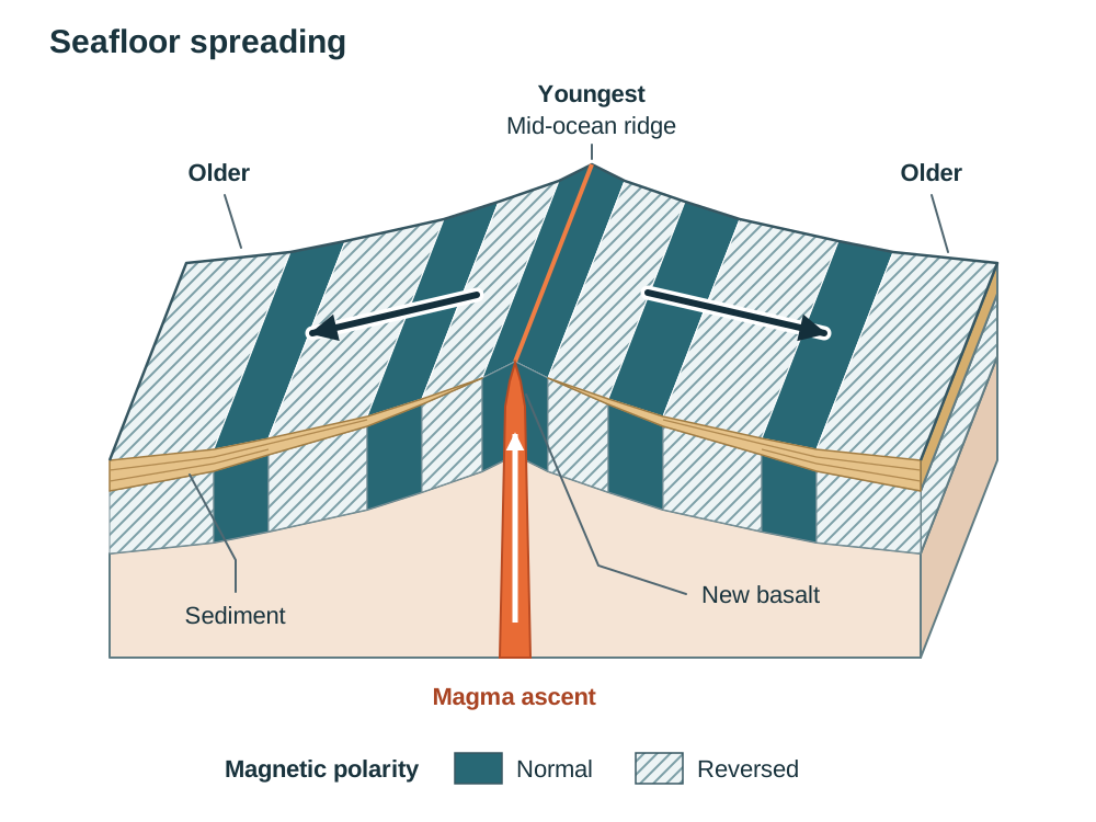
Hess synthesised these findings into seafloor spreading. Convection currents pull oceanic plates apart at mid-ocean rifts. Basaltic magma wells up, cools on contact with seawater, and forms new oceanic crust. As more magma emerges, it pushes older crust outward on both sides.
Evidence Proving Seafloor Spreading
- Age of crust: Radiometric dating shows oceanic crust is youngest at the mid-ocean ridge (under 10 million years) and gets progressively older towards continental margins (up to 180 million years).
- Ocean sediment depth: Marine sediment layers are almost non-existent at the ridge crest and grow steadily thicker towards continental margins.
- Palaeomagnetism (magnetic striping): Iron minerals in cooling basalt lock into alignment with the Earth's magnetic field. Because the magnetic field reverses every few hundred thousand years, the ocean floor exhibits alternating bands of normal and reversed magnetism. These bands form a symmetrical, mirror-image pattern on either side of the Mid-Atlantic Ridge, proving that crust forms at the centre and spreads outwards (Vine and Matthews, 1963).
Plate Boundaries and Global Distribution of Volcanoes and Earthquakes
The Earth's crust is divided into major plates: North American, South American, Eurasian, African, Indo-Australian, Pacific, and Antarctic, alongside smaller plates such as the Nazca, Cocos, Caribbean, and Philippine plates.
Volcanoes and earthquakes are not distributed randomly. They concentrate in narrow belts along plate margins:
- The Pacific Ring of Fire: A horseshoe-shaped belt circling the Pacific Ocean basin holding roughly 75% of active volcanoes and 90% of all recorded earthquakes. It is formed by subduction zones where the Pacific, Nazca, and other plates plunge beneath adjacent continental and island arcs (e.g. the Andes, Japan, the Aleutian Islands, and Mount Pinatubo in the Philippines).
- Mid-Ocean Ridges: Constructive margins producing gentle basaltic fissure eruptions and shallow earthquakes (e.g. the Mid-Atlantic Ridge and Iceland).
- Alpine-Himalayan Belt: A continental collision zone producing frequent, mainly shallow earthquakes but little volcanism, running through the Mediterranean, Turkey, Iran and the Himalayas (e.g. the 2015 Nepal earthquake).
- Hotspots: A crucial exception to boundary distribution. A hotspot occurs where an isolated mantle plume of intense heat burns through the moving plate above, forming volcanoes in the middle of plates (e.g. the Hawaiian Islands in the Pacific Plate, or Iceland, where a hotspot coincides with the Mid-Atlantic Ridge).
Today Ireland lies near the western edge of the Eurasian Plate, over 1,000 km from the nearest boundary (the Mid-Atlantic Ridge). This stable intraplate position is why Ireland has no active volcanoes and experiences only minor seismic tremors.
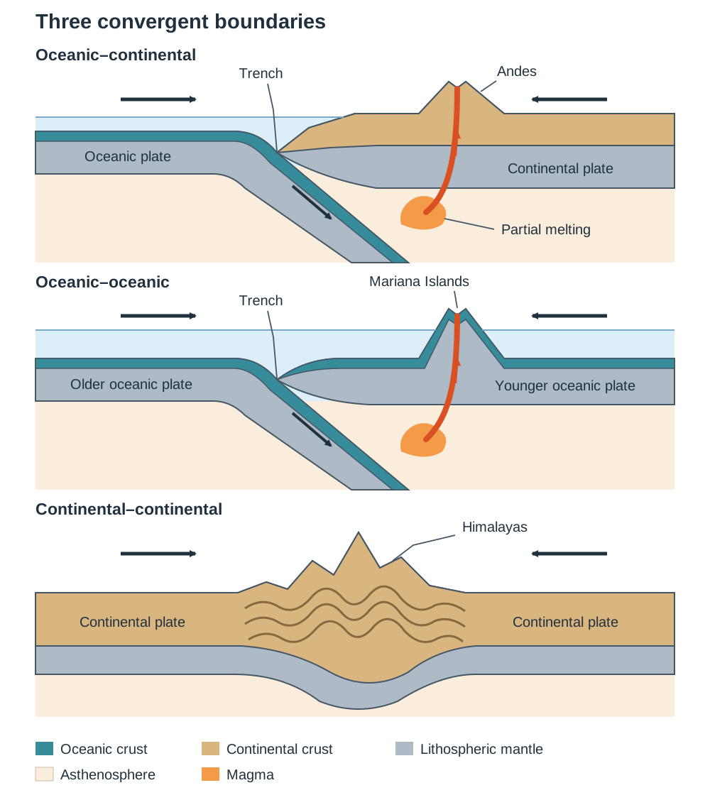
The Three Boundary Types
1. Divergent (Constructive) Boundaries
Plates separate under tension caused by diverging mantle currents.
- Processes and Landforms: The crust fractures into fissures and normal faults. Basaltic magma rises, solidifies, and creates new ocean floor via seafloor spreading, building mid-ocean ridges. Shallow earthquakes occur along fault lines.
- Examples: The Mid-Atlantic Ridge, where the North American and Eurasian plates pull apart at 2 to 3 cm per year; Iceland, where this ridge rises above sea level.
2. Convergent (Destructive) Boundaries
Plates collide under compression.
- Oceanic–Continental: The denser oceanic plate subducts beneath the lighter continental plate into the asthenosphere. The seabed is dragged down to form an ocean trench. Trapped seawater lowers the melting point of mantle rocks, creating silica-rich magma that rises to build explosive stratovolcanoes and fold mountains along the continental edge. Example: The Nazca Plate subducting under the South American Plate, forming the Peru-Chile Trench and the Andes.
- Oceanic–Oceanic: The older, colder, and denser oceanic plate sinks beneath the younger oceanic plate. Melting creates magma that erupts onto the seabed, eventually building an arc of volcanic islands parallel to an ocean trench. Example: The Pacific Plate subducting beneath the Philippine Plate, forming the Mariana Trench (11 km deep) and the Mariana Islands; Japan and the Aleutian Islands are further island arcs.
- Continental–Continental: Neither buoyant granitic plate can sink into the dense mantle. The crust buckles, fractures, and pushes upwards, creating high, non-volcanic fold mountains and severe earthquakes. Example: The Indo-Australian Plate colliding with the Eurasian Plate, uplifting the Himalayas.
3. Transform (Conservative / Passive / Neutral) Boundaries
Two plates slide past each other horizontally along a tear fault under shearing stress. Crust is neither created nor destroyed, and there are no volcanoes.
- Processes and Landforms: Plate edges lock due to friction. Stress accumulates over decades until the rock snaps, releasing energy in shallow, violent earthquakes.
- Example: The San Andreas Fault in California, where the Pacific Plate slides north-west past the North American Plate.
Earthquake and Volcanic Activity: Measurement and Prediction
Understanding Earthquakes
- Focus: The subterranean point along a fault plane where rock ruptures and seismic energy is released.
- Epicentre: The point on the Earth's surface directly above the focus; surface shaking and damage are typically greatest here.
- Seismic Waves: Shock waves radiating from the focus. Fast Primary (P) waves arrive first, Secondary (S) waves arrive second, and surface (L) waves arrive last, causing the most severe structural damage.
- Seismograph (Seismometer): An instrument that detects and records seismic waves. A network of seismic stations calculates differences in arrival times to determine the epicentre location and depth.
- Magnitude: The energy released, recorded on the Richter scale or moment magnitude scale. Because the scale is logarithmic, each whole number increase represents approximately 32 times more energy (e.g. the 2015 Nepal earthquake had a magnitude of 7.8).
- Predicting and Mitigating Earthquakes: Exact dates and times cannot be predicted. Swarms of small tremors may precede an event, and scientists monitor micro-cracking and radon gas changes, but these indicators are unreliable. Authorities focus on hazard mapping and reducing impacts: enforcing strict building codes, installing base isolators (rubber and steel bearings under foundations), adding steel cross-bracing, and fitting automatic shut-off valves on municipal gas mains.
Monitoring and Predicting Volcanoes
Volcanoes provide clearer advance warnings because rising magma must physically displace crustal rock:
- Ground deformation: Rising magma bulges the volcano. Laser tiltmeters and GPS measure swelling to millimetre accuracy (e.g. Mount St Helens bulged 1.5 m per day prior to its 1980 eruption; Grindavík in Iceland was successfully evacuated in 2023 following ground deformation).
- Volcanic tremors: As magma forces open cracks, it triggers a continuous rumbling of small earthquakes recorded on local seismometers.
- Gas emissions: Escaping gases, particularly sulphur dioxide and carbon dioxide, spike sharply as magma nears the surface (e.g. gas monitoring enabled the timely evacuation of 60,000 people before Mount Pinatubo erupted in 1991).
- Thermal changes: Infrared satellite sensors track rising ground surface temperatures around the summit vent or caldera (a large hollow formed when the top of a volcano collapses after its magma chamber empties).
Crustal Deformation: Folding, Doming, and Ireland's Mountain Framework
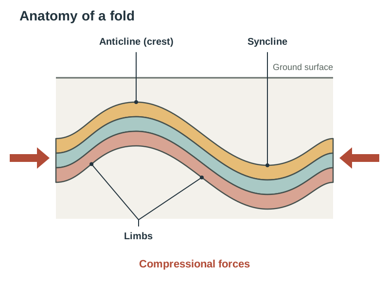
Under intense heat and pressure deep within the crust, solid rock becomes ductile, meaning it bends without breaking. Lateral compression during continental collisions forces rock strata to buckle into folds.
Anatomy of a Fold
- Anticline: The upward-arching crest of a fold, which commonly forms mountain ridges.
- Syncline: The downward-curving trough of a fold, which commonly forms valleys.
- Limbs: The sloping rock layers connecting an anticline to an adjacent syncline.
Diagram guidance: To draw a fold structure, sketch a continuous wavy line showing alternating upward and downward bends. Label the upward arch as the 'anticline (crest)', the downward trough as the 'syncline', and the sloping flanks between them as 'limbs'. Add horizontal arrows pointing inward from both sides labelled 'compressional forces'.
Fold Geometries
- Symmetrical: Both limbs dip at identical angles, reflecting equal compression from both sides.
- Asymmetrical: Unequal compression pushes one limb steeper than the other.
- Overturned: Severe one-sided compression tilts both limbs in the same direction, inverting the underlying strata.
- Recumbent: Extreme compression causes the fold axis to lie almost flat horizontally.
- Overthrust: Stress exceeds rock elasticity, fracturing the fold along a low-angle thrust plane so one rock mass is driven over the other.
Doming Structures
Doming occurs when rising magma beneath the crust pushes overlying rock layers upward into a round, upturned-bowl shape (a circular or oval anticline), or when rocks are compressed from multiple directions simultaneously. Exogenic weathering and erosion gradually strip away the top layers, exposing the older rock at the centre of the dome. An Irish example is the Slieve Bloom Mountains in Counties Laois and Offaly, which formed when magma associated with the Leinster Batholith surged upwards roughly 400 million years ago.
Orogenies Shaping the Irish Landscape
A mountain-building period is called an orogeny:
- Caledonian Orogeny (450–400 million years ago): The ancient Iapetus Ocean closed as the Laurentian (North American) and Avalonian (European) continental plates collided, joining the two halves of Ireland together along the Iapetus Suture (a line running from the Shannon Estuary to Clogherhead, Co. Louth). Intense compression folded sandstones, mudstones, and shales along a distinct NE–SW trend. Magma intruded into the fold cores, cooling to form the Leinster Batholith granite; heat baked adjacent shales into mica schist (contact metamorphism) capping peaks like Lugnaquilla. Regional metamorphism converted sandstones into durable quartzite, forming the cone of Croagh Patrick in Co. Mayo and the Twelve Bens in Connemara. The Wicklow Mountains follow this NE–SW axis.
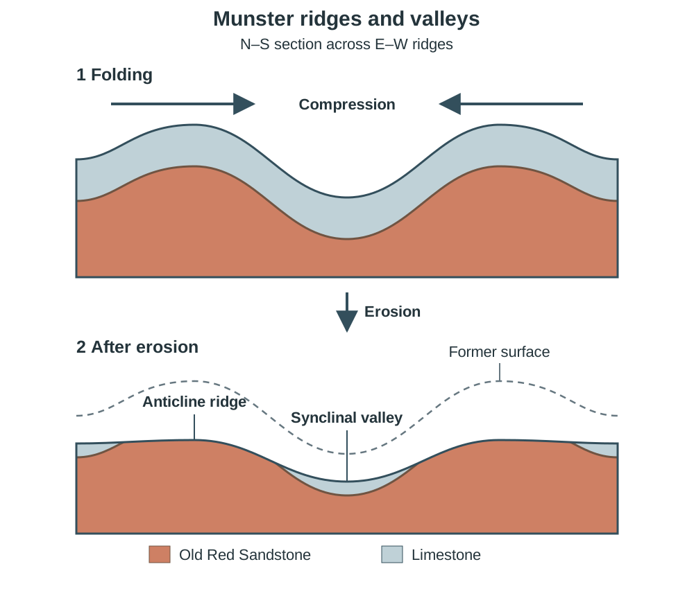
- Armorican Orogeny (270–250 million years ago): Compression from the south folded southern Ireland along a distinct E–W axis, producing the Munster Ridge and Valley province. Devonian Old Red Sandstone buckled into anticline ridges forming the MacGillycuddy's Reeks (including Carrauntoohil, 1,038 m), the Galtees, and the Comeraghs. Less resistant Carboniferous limestone in the intervening synclines was worn down by weathering and river erosion, forming valleys through which the Blackwater, Lee, and Bandon flow.
- The Antrim Basalts (60 million years ago): While the Alpine orogeny (peaking 35 million years ago) uplifted the Alps, it only gently tilted Irish strata. However, crustal rifting as the North Atlantic opened produced volcanic fissure eruptions across north-east Ireland, creating the Antrim basalt plateau and the Giant's Causeway.
Crustal Deformation: Faulting and Associated Landforms
Near the surface, cool rocks are brittle. When tectonic stress exceeds rock strength, strata fracture and move. Faulting involves the definite displacement of rock masses along a fracture.
Features of a Fault
- Fault plane: The fracture surface along which rocks slip.
- Fault scarp (escarpment): The steep exposed cliff face created at the surface by vertical displacement.
- Hanging wall: The rock mass resting directly above an inclined fault plane.
- Footwall: The rock mass positioned directly beneath the inclined fault plane.
- Throw and heave: Throw is the vertical displacement; heave is the horizontal displacement.
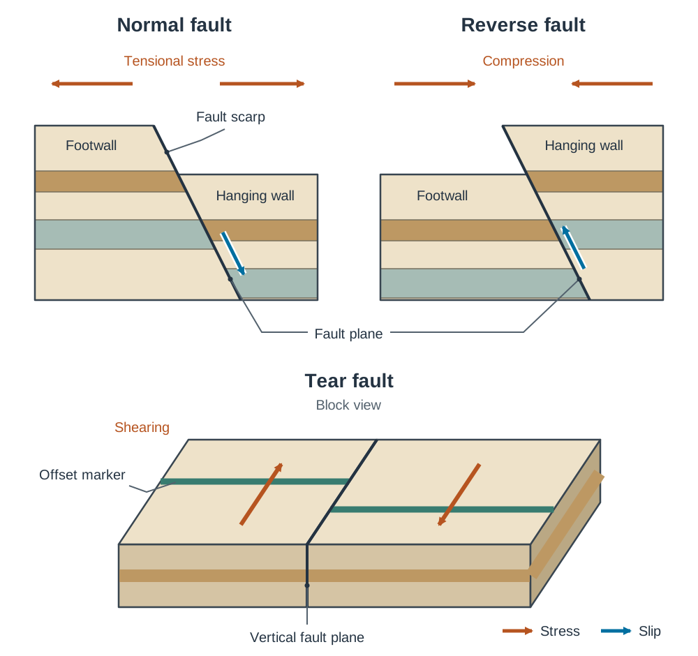
Diagram guidance: For a normal fault, draw a diagonal fracture line sloping down to the right. The upper wedge (hanging wall) is shown displaced downward relative to the footwall. Mark arrows pulling outwards labelled 'tensional stress', and label the exposed cliff face as the 'fault scarp'. For a reverse fault, show arrows pushing inward and the hanging wall pushed upward over the footwall.
Fault Types and Associated Landforms
- Normal faults (Tension): Crust is stretched, causing the hanging wall to slip downward relative to the footwall.
- Rift valley (graben): A long, flat-bottomed valley formed when a central crustal block drops down between two parallel normal faults. Global examples include the East African Rift Valley, the Rhine Rift Valley between the Vosges and Black Forest, and the Þingvellir rift valley in Iceland. In Ireland, Lough Neagh occupies a down-faulted crustal basin.
- Block mountain (horst): An elevated crustal block left standing above the surrounding landscape between parallel normal faults when the sides drop down (or pushed up between reverse faults under compression). Global examples include the Black Forest and Vosges; an Irish example is the Ox Mountains in Co. Sligo.
- Reverse and thrust faults (Compression): Crust is squeezed, forcing the hanging wall upward over the footwall. When the fault plane angle is low (under 45°), it is called a thrust fault. An Irish example is the Killarney–Mallow Thrust Fault, where Old Red Sandstone was pushed northward over Carboniferous limestone during the Armorican orogeny.
- Tear faults (Shearing): Crustal blocks slide past each other horizontally along a vertical fault plane with minimal vertical lift. In Ireland, the Leannan Fault in Co. Donegal is a major tear fault related to Scotland's Great Glen fault system.
Key terms
- Endogenic forces
- Forces originating inside the Earth, powered by geothermal heat, that build up the landscape through plate movement, volcanism, earthquakes, folding, and faulting.
- Exogenic forces
- External processes operating on the Earth's surface that wear down the landscape, including weathering and erosion by water, ice, and wind.
- Lithosphere
- The rigid, brittle outer layer of the Earth, consisting of the crust and the solid uppermost mantle, fractured into tectonic plates.
- Asthenosphere
- The semi-molten, ductile layer of the upper mantle directly beneath the lithosphere, capable of slow flow driven by convection currents.
- Mohorovičić discontinuity (Moho)
- The boundary separating the Earth's crust from the denser upper mantle, marked by an abrupt increase in seismic wave velocity.
- Subduction
- The tectonic process at convergent boundaries where a denser plate (typically oceanic) sinks beneath a lighter plate into the mantle.
- Seafloor spreading
- The creation of new basaltic oceanic crust at mid-ocean ridges as magma rises and cools, pushing older seafloor outward on either side.
- Pacific Ring of Fire
- A horseshoe-shaped zone circling the Pacific Ocean basin where intense subduction produces 75% of the world's active volcanoes and 90% of earthquakes.
- Hotspot
- An isolated, stationary column of hot upwelling mantle rock (mantle plume) that melts through an overlying moving plate to form intraplate volcanoes, such as Hawaii.
- Focus
- The point underground along a fault line where rock fractures and an earthquake originates.
- Epicentre
- The point on the Earth's surface situated directly above the underground focus of an earthquake.
- Anticline
- An upward-arching crest in folded rock strata produced by compressional tectonic forces.
- Syncline
- A downward-curving trough in folded rock strata produced between adjacent anticlines by compressional forces.
- Doming
- A circular or oval upward bulge in crustal rock layers caused by rising magma or multi-directional compression, later exposed by erosion.
- Orogeny
- A major geological period of mountain building driven by tectonic plate convergence, folding, and faulting.
- Normal fault
- A rock fracture produced by tensional forces where the hanging wall slips downward relative to the footwall.
- Reverse fault
- A rock fracture produced by compressional forces where the hanging wall is forced upward over the footwall.
- Rift valley (graben)
- A sunken, steep-sided valley formed when a block of the Earth's crust drops downward between parallel normal faults under tension.
- Block mountain (horst)
- An elevated block of crust left standing higher than the surrounding down-faulted land between two parallel faults.
Check yourself
What is the primary difference between endogenic and exogenic forces?
Endogenic forces originate within the Earth, driven by internal heat, to build up the landscape (e.g. folding, volcanism), while exogenic forces act on the surface to wear it down (e.g. weathering, river erosion).
Why does the seafloor on either side of the Mid-Atlantic Ridge display alternating magnetic stripes?
Iron minerals in cooling basalt align with the Earth's magnetic field at the time of eruption. Because the Earth's magnetic poles periodically reverse, new crust creates a symmetrical, mirror-image pattern of normal and reversed magnetism as it spreads outward.
What is the difference between the focus and the epicentre of an earthquake?
The focus is the exact point underground along a fault where the rock ruptures, whereas the epicentre is the point on the Earth's surface directly above the focus.
Why do the Hawaiian Islands have active volcanoes despite lying thousands of kilometres from any plate boundary?
Hawaii sits over a stationary mantle plume or hotspot. As the Pacific Plate moves slowly north-west over this persistent heat source, magma melts through the plate, creating an age-progressive chain of volcanic islands.
Which tectonic force causes normal faulting, and which causes reverse faulting?
Tension (stretching) causes normal faulting, while compression (squeezing) causes reverse faulting.
Which ancient ocean closed during the Caledonian orogeny, and what is the name of the boundary where the two halves of Ireland joined?
The Iapetus Ocean closed, and the two halves joined along the Iapetus Suture.