

Optional Unit 8 (Culture and Identity) is examined exclusively at Higher Level as an 80-mark discursive essay in Part Two of the terminal examination. It carries 20% of the written paper (80 out of 400 marks) and 16% of your overall Leaving Certificate grade (80 out of 500 marks when including the Geographical Investigation). The unit explores how human populations group and define themselves across three areas: physical and cultural indicators such as race, language, religion, and everyday expressions of culture (8.1); nationality, political and physical boundaries, and state-minority conflicts (8.2); and an in-depth European regional case study—specifically Switzerland—evaluating boundaries, multilingualism, cross-cutting religious cleavages, and migration (8.3). Higher Level success requires structured answers built from distinct, named aspects containing a dense run of Significant Relevant Points (SRPs).
Exam Structure, Timing, and Essay Architecture
The Higher Level Geography paper lasts 2 hours 50 minutes (170 minutes) for 400 marks. Part One contains 12 short questions (80 marks, complete 10), while Part Two contains four 80-mark questions: Physical Geography, Regional Geography, your chosen Elective, and one essay from the Options section. Budget roughly 30 minutes for Part One and 35 minutes for each 80-mark question. The option essay carries the same weight as an entire regional geography question, so never leave it to a panicked 15 minutes at the end of the exam.
Option questions are evaluated on Significant Relevant Points (SRPs) and overall coherence. Each SRP is a distinct statement of factual geographical knowledge: a named location, an accurate date, a specific census figure, a piece of legislation, or a direct cause-and-effect explanation. Sweeping generalisations and unsupported narrative receive no credit.
Organise your answer into three or four named aspects written as underlined headings:
- Under a three-aspect approach, aim for 8 to 10 SRPs per aspect (giving roughly 24 to 30 SRPs in total).
- Under a four-aspect approach, provide 6 to 8 SRPs per aspect.
- In both approaches, the remaining marks reward coherence, logical sequencing, and geographical terminology.
Be alert to mark splits in the exam paper. Questions are frequently divided: for example, 'Examine the influence of language on cultural identity (40 marks) and discuss policies to support minority languages (40 marks).' If you see a 40/40 split, divide your aspects and points evenly across both halves rather than writing an unbalanced essay.
Handling Stimulus Material and Skills
Option questions often include stimulus material such as language distribution maps, census graphs, or religious population tables. Use a reliable four-step routine:
- Read the title, scale, axis labels, and dates carefully.
- State the overall geographical trend in your opening sentence.
- Quantify the pattern by citing highest values, lowest values, and calculated changes over time.
- Explain the human or physical processes driving the pattern and connect them directly to your essay themes.
If drawing an explanatory sketch map (such as Switzerland's linguistic regions or Gaeltacht boundaries in Ireland), keep it concise, clear, and fully labelled. Unlabelled sketch maps receive zero marks.
Physical Indicators, Colonisation, and Racial Conflict
Geographers treat race as a social construct—a set of human classification categories invented by societies rather than an objective biological reality. Modern genetics demonstrates that all humans belong to the single species Homo sapiens and share 99.9% of their DNA. The remaining 0.1% accounts for all observable physical variations, such as skin pigmentation, hair form, and facial characteristics.
These visible differences evolved through natural selection as populations adapted to varying intensities of ultraviolet (UV) radiation. High melanin concentrations protect deeper epidermal layers from UV damage in equatorial regions. In northern latitudes, lower melanin levels allow sufficient UV penetration to synthesise essential vitamin D. Over millennia, human migrations—beginning with the 'Out of Africa' dispersal between 70,000 and 100,000 years ago—established global population patterns across continents. Today, populations of African descent are concentrated across sub-Saharan Africa, with an extensive diaspora across Brazil, the Caribbean, and the United States established through the slave trade. Populations of European descent dominate Europe and, through historical colonial settlement, large parts of the Americas, Australia, and southern Africa. Populations of Asian descent are concentrated in East, South-East, and South Asia, with significant communities in East Africa, the Caribbean, and Britain created by indentured labour and post-colonial migration. These locational patterns record historical migration, colonialism, and global economic movements rather than any natural biological division of humanity.
Colonialism and the Trans-Atlantic Slave Trade
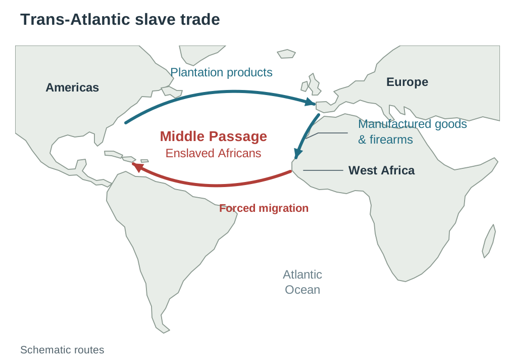
Modern racial distributions were fundamentally reorganised by European imperial expansion. Between the 16th and 19th centuries, the trans-Atlantic slave trade operated across a triangular route connecting Europe, West Africa, and the Americas. European ships traded manufactured items and firearms for captive Africans, who were transported across the Atlantic via the brutal Middle Passage to supply forced labour on American sugar, tobacco, and cotton plantations.
Roughly 12.5 million enslaved Africans were transported, creating the global African diaspora. The systematic abduction of young, productive individuals disrupted African demographic structures, economies, and indigenous political systems. In destinations like Brazil, which received approximately 4.8 million enslaved people, widespread racial mixing (mestiçagem) emerged alongside syncretic religions (such as Candomblé) and musical traditions like samba.
Racial Conflict: South Africa and the United States
Racial conflict occurs when institutional power, economic resources, or legal rights are distributed unequally along ethnic lines.
- Apartheid in South Africa (1948–1994): The National Party government codified white minority supremacy through spatial segregation. The Population Registration Act of 1950 classified all South Africans into four racial groups: White, Black, Coloured, and Asian. The Group Areas Act of 1950 designated separate residential areas in urban centres, forcibly displacing over 3.5 million non-white citizens. Dynamic mixed neighbourhoods like District Six in Cape Town were demolished, forcing residents into distant, poorly serviced townships such as Mitchells Plain. Ten fragmented Bantustans (homelands) were created, allocating roughly 13% of the poorest land to 75% of the population. Strict pass laws controlled internal movement until domestic protests (Sharpeville in 1960, Soweto in 1976), international boycotts, and negotiations led to the first democratic non-racial elections in April 1994. Despite constitutional equality, the spatial legacy of apartheid persists in extreme wealth gaps and persistent urban residential segregation.
- Racial Conflict in the United States: Developed through five clear historical stages: plantation slavery prior to 1865; post-Civil War Black Codes; the institutionalisation of Jim Crow laws in southern states mandating segregated public facilities, restricting voting rights via poll taxes and literacy tests, and enforcing residential segregation; the Civil Rights Movement of the 1950s and 1960s, which secured federal legislative change through the Civil Rights Act of 1964 and the Voting Rights Act of 1965; and the modern Black Lives Matter movement founded in 2013, which campaigns against racially biased policing and systemic economic disparities.
Multicultural Ireland and Direct Provision
Economic expansion following EU entry in 1973 transformed Ireland into a destination country. Census 2022 recorded 631,785 non-Irish citizens residing in the state, representing 12% of the population, with major cohorts from Poland, the United Kingdom, India, and Romania. Integration challenges include xenophobia, workplace discrimination, and the controversial Direct Provision system. Established in 2000 as temporary emergency accommodation for international protection applicants, it accommodates over 20,000 residents who often face long wait times, shared living arrangements, and limited integration opportunities.
Language as a Cultural Indicator and Policies for Survival
Language is the most distinctive cultural indicator, carrying historical narratives, oral folklore, literature, and regional identity. Most languages belong to major ancestral families: Indo-European (Europe, the Americas, and northern South Asia), Sino-Tibetan (East Asia), Afro-Asiatic (North Africa and the Middle East), and Niger-Congo (sub-Saharan Africa).
Of the world's roughly 7,000 spoken languages, UNESCO projects that up to 40% face the threat of extinction. The spread of global telecommunications, international commerce, and internet platforms has driven linguistic homogenisation. English functions as the predominant global lingua franca, spoken by over 1.5 billion people across more than 70 nations, accounting for roughly a quarter of all internet traffic.
Comparative Analysis: Minority Language Policies in Ireland and Wales
Research on the Gaeltacht found that once fewer than about two-thirds of a community speak Irish daily, the language stops being passed on naturally within that community. Language planners use daily community use, not overall ability, as the key warning sign of decline. Both Ireland and Wales have implemented state-led survival policies.
| Policy Lever | Gaeilge (Ireland) | Cymraeg (Wales) |
|---|---|---|
| Historical Decline | Tudor and Stuart plantations displaced Irish from legal and administrative life. The Great Famine (1846–1852) caused 1 million deaths and 1 million emigrations in western regions; Irish speakers dropped from 50% (4 million) in 1832 to 15% by 1871. | The 19th-century 'Welsh Not' punished school pupils speaking Welsh. 19th-century industrialisation in the South Wales coal valleys introduced large English-speaking workforces. |
| Legal Status | Article 8 of Bunreacht na hÉireann (1937) confirms Irish as the national and first official language. The Official Languages Act 2003 established public service language rights. Full EU working status was granted in 2022. | The Welsh Language Act 1967 permitted Welsh in court proceedings. The Welsh Language Measure 2011 established Welsh as an official language with statutory equality in public bodies. |
| Education Policy | Compulsory subject across primary and secondary curricula. Growth of immersion Gaelscoileanna and Gaeltacht summer colleges (Coláistí Samhraidh). | Compulsory subject up to age 16. Roughly a quarter of primary pupils receive Welsh-medium schooling. Cymraeg 2050 targets training 5,200 fluent teachers. |
| Media and Enterprise | Public broadcasting via TG4 (established 1996) and RTÉ Raidió na Gaeltachta. Údarás na Gaeltachta funds economic development and enterprise hubs in Gaeltacht areas. | S4C (established 1982) provides dedicated Welsh-language television. Over 90% of Welsh public authority digital services operate bilingually. |
| Current Challenges | Census 2022: 1.87 million reported an ability to speak Irish, but only 71,968 speak it daily outside education. High youth emigration in rural areas threatens language density. | The Cymraeg 2050 strategy aims for 1 million speakers by 2050. Census 2021 recorded 538,300 Welsh speakers (17.8%), though surveys show wider basic spoken ability. |
Four standard policy levers protect minority languages: constitutional recognition, school curricula and immersion education, dedicated broadcasting and digital media, and regional economic funding so young speakers can find local employment.
Religion as a Cultural Indicator: Global Distribution, Church-State, and Conflict
Religion shapes societal moral frameworks, architectural landscapes, diet, and seasonal calendars. Geographers classify faiths into universalising religions (which actively seek converts and diffuse across continents) and ethnic religions (which are closely identified with a specific cultural group or territory).
Global Distribution and Diffusion of Major World Religions
- Christianity (roughly 2.4 billion followers): Universalising faith originating in south-west Asia. Dominant in Europe, North and South America, Australia, parts of sub-Saharan Africa, and the Philippines. Diffused through Roman roads, monastic missions, and European colonial expansion.
- Islam (roughly 1.9 billion followers): Universalising faith with its hearth in Mecca, Arabia. Predominant across North Africa, the Middle East, Central Asia, Pakistan, and Bangladesh. Indonesia holds the world's largest national Muslim population (over 230 million), demonstrating maritime trade diffusion.
- Hinduism (roughly 1.2 billion followers): Ethnic faith concentrated primarily in India and Nepal. Migration established diaspora communities in Mauritius, Fiji, Guyana, and the United Kingdom.
- Buddhism (roughly 500 million followers): Universalising faith originating in northern India, now concentrated across East and South-East Asia, including China, Thailand, Myanmar, Japan, and Sri Lanka.
- Sikhism (roughly 26 million followers): Hearth in the Punjab region of north-west India, with significant diaspora communities in the UK, Canada, and the United States.
- Judaism (roughly 15 million followers): Ethnic faith historically dispersed across a global diaspora; today concentrated in Israel, the United States, and western Europe.
Religion leaves deep imprints on the physical and cultural landscape. Urban skylines are defined by church spires, minarets, and temple towers (gopurams). Irish placenames reflect monastic sites (Kill- from cill, a church, as in Kilkenny; Donagh- from domhnach, church lands). Pilgrimages generate seasonal mass movements: the annual Hajj brings over 2 million pilgrims to Mecca, while Croagh Patrick and Lough Derg draw pilgrims in Ireland.
Church-State Relations in Ireland
Following independence in 1922, the Roman Catholic Church exercised extensive moral, educational, and political control. Article 44 of the 1937 Constitution recognised the 'special position' of the Catholic Church (removed by referendum in 1972). Clerical influence was demonstrated in 1951 when Catholic bishops opposed the Mother and Child Scheme, prompting Minister for Health Dr Noël Browne to resign over proposals for free mother and infant healthcare.
Beginning in the 1990s, judicial abuse inquiries and changing social norms accelerated secularisation: the decriminalisation of male homosexuality (1993), civil divorce by referendum (1995), marriage equality (2015), and the repeal of the Eighth Amendment regarding abortion (2018). While roughly 90% of primary schools remain under Catholic patronage, the Education (Admission to Schools) Act 2018 removed the 'baptism barrier' in oversubscribed Catholic schools.
International Religious Conflict: Bosnia-Herzegovina
When Yugoslavia collapsed in 1991–1992, Bosnia-Herzegovina declared independence. Its population was roughly 44% Bosniak (Muslim), 31% Serb (Orthodox Christian), and 17% Croat (Catholic), living interspersed in the same towns.
Between 1992 and 1995, armed conflict claimed approximately 100,000 lives. Factions carried out ethnic cleansing—the forced expulsion of a population to make a territory culturally and religiously uniform—displacing over 2 million people. Sarajevo was besieged for nearly four years. In July 1995, Bosnian Serb forces murdered over 8,000 Bosniak men and boys at Srebrenica.
The conflict was halted by the Dayton Agreement (1995), which partitioned the state into two internal autonomous entities along religious and ethnic lines: the Republika Srpska (Serb Orthodox majority) and the Federation of Bosnia and Herzegovina (Bosniak Muslim and Croat Catholic). This boundary demarcation created an enduring spatial partition visible in everyday life, including divided municipal services and segregated schools.
Nationality, Boundaries, and Political Conflicts
Political geography makes clear distinctions between political and cultural units:
- A nation is a distinct community of people united by common language, shared historical memories, and collective consciousness (e.g. Kurds, Basques).
- A state is an independent political entity with an established government, recognised international frontiers, and sovereign authority over territory and population.
- A nation-state exists where the territorial frontiers of a state correspond to a culturally uniform population (e.g. Iceland, Japan).
Boundary Classifications and Colonial Superimposition
Boundaries fall into several distinct geographical categories:
- Physical boundary: Follows a natural landscape barrier, such as mountain ranges (the Pyrenees between Spain and France) or major river systems (the Rio Grande).
- Political boundary: An artificial line created by diplomatic negotiation, war, or administrative decree.
- Superimposed boundary: A political frontier forced onto an existing cultural landscape by outside powers, ignoring ethnic, linguistic, or tribal divisions. At the Berlin Conference (1884–1885), 14 delegations (13 European, plus the US; no African representatives) partitioned the African continent. By 1914, roughly 90% of Africa was under European colonial rule. Over 40% of Africa's borders were drawn as straight geometric lines along parallels of latitude and meridians of longitude. This split cultural groups (such as the Somali people divided across Somalia, Ethiopia, Djibouti, and Kenya; and the Maasai split between Kenya and Tanzania) while forcing rival groups into single volatile entities (e.g. Nigeria with over 250 ethnic groups).
- Relic boundary: A former border that is no longer politically operational but remains visible in the cultural and urban landscape, such as the route of the former Berlin Wall.
The Partition of Ireland
The border on the island of Ireland illustrates how an artificial political boundary affects cultural and economic geography:
- The Government of Ireland Act 1920 partitioned the island into Southern Ireland (which became the Irish Free State in 1922) and Northern Ireland, which retained British jurisdiction.
- The border included six north-eastern counties (Antrim, Armagh, Down, Fermanagh, Londonderry/Derry, and Tyrone). The three remaining Ulster counties (Cavan, Monaghan, and Donegal) were excluded because including them would have compromised the unionist political majority, despite nationalist majorities residing in Fermanagh and Tyrone.
- The boundary was drawn to create a unionist political majority, not to follow physical topography or cultural boundaries. A Boundary Commission set up under the Anglo-Irish Treaty saw its 1925 report suppressed, confirming the 1920 border unaltered.
- Running roughly 500 km with approximately 300 road crossings, the border severed natural trade hinterlands—such as east Donegal from Derry city—and separated farms, parishes, and water catchments.
- Border checkpoints operated until the European Single Market removed internal customs checks in 1993. Following the 2016 UK Brexit vote, the border became an external frontier of the EU single market. To prevent a hard land border, the Northern Ireland Protocol and the Windsor Framework (2023) placed customs checks on goods moving from Great Britain into Northern Ireland across the Irish Sea, creating opposition from unionist communities who argue this compromises Northern Ireland's constitutional place in the UK.
Northern Ireland Case Study Spine
Plantation (1609) → Partition (1920–1921) → Gerrymandering and housing inequality → Civil Rights marches (1968) → The Troubles (3,500+ deaths) → Good Friday Agreement (1998) → Ongoing separation (only 7% integrated schooling; 59 peace walls in Belfast) → Brexit trade border debates.
European Region Case Study: Culture and Identity in Switzerland
Switzerland provides the primary European regional case study of how diverse linguistic and religious groups maintain a stable national identity. The Swiss define their country as a Willensnation ('nation by will')—a state unified by mutual consent, shared federal institutions, and direct democracy rather than a common language or single ethnic identity.
1. Physical Barriers and Historical Evolution
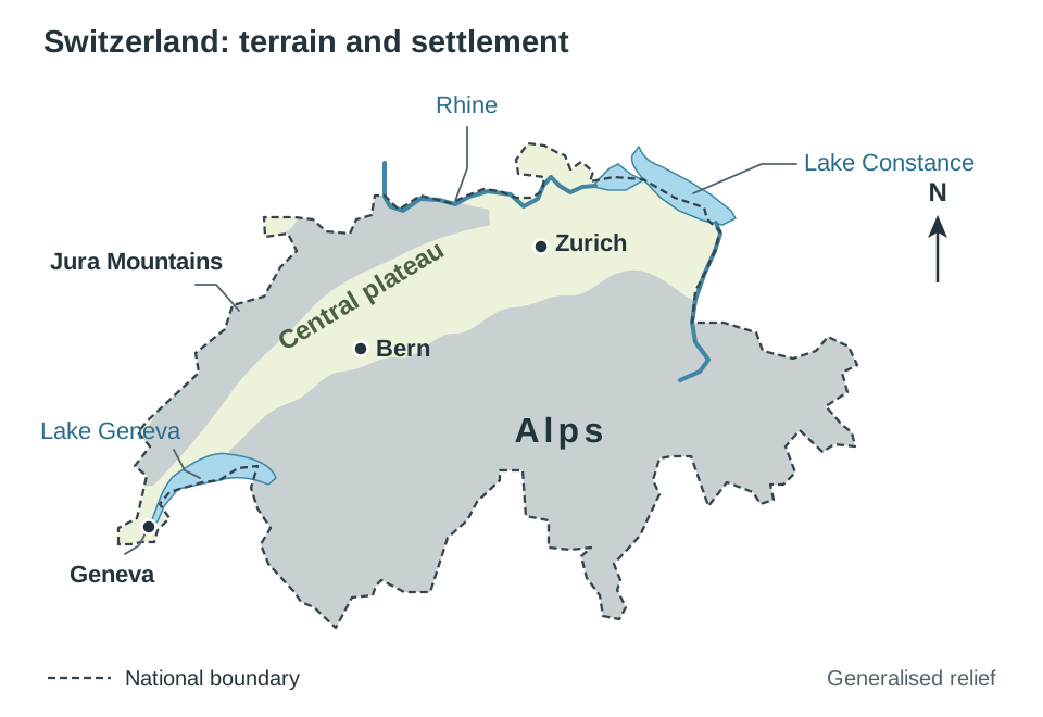
Switzerland occupies a central European position sheltered behind natural barriers: the Alps to the south and east, the Jura Mountains to the north-west, alongside the Rhine River, Lake Geneva, and Lake Constance. These topographical features historically sheltered the confederation from external invasion, facilitated armed neutrality (guaranteed at the Congress of Vienna in 1815), and enabled autonomous communities to develop. Rugged topography confines over 70% of the population to the lower central plateau, driving urban concentration in Zurich, Bern, and Geneva.
In 1291, three forest cantons—Uri, Schwyz, and Unterwalden—signed a mutual defense alliance. Following the 1847 Sonderbund War, the Swiss Constitution of 1848 created the modern federal state, now comprising 26 cantons (20 full and 6 half cantons).
2. Linguistic Accommodation
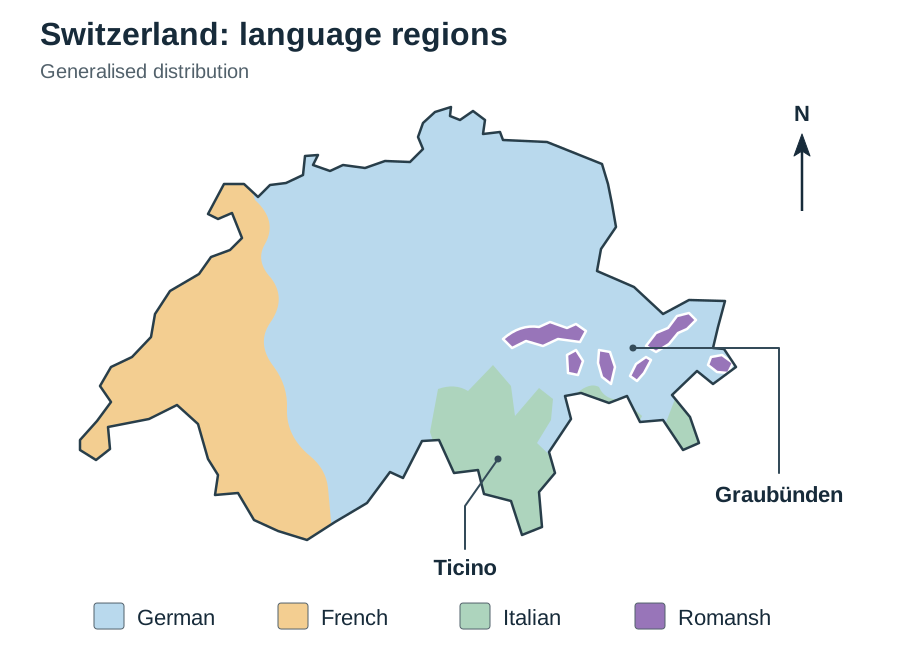
Switzerland balances four official national languages across distinct regions:
- German: Spoken by 63% of the population (central, northern, and eastern cantons)
- French: Spoken by 23% (western Suisse Romande around Geneva, Vaud, and Neuchâtel)
- Italian: Spoken by 9% (southern canton of Ticino and southern Graubünden)
- Romansh: Spoken by under 1% (alpine valleys of Graubünden)
Federal statutes and official proceedings are published in German, French, and Italian. To maintain strict parity, Swiss currency and postage stamps use the neutral Latin title Confoederatio Helvetica (abbreviated as CH). Schooling emphasises early language acquisition: 64% of Swiss adults report speaking at least two languages regularly.
3. Cross-Cutting Religious Cleavages
During the 16th-century Reformation, Zurich (led by Zwingli) and Geneva (led by Calvin) adopted Protestantism, while rural central cantons remained Catholic. In Switzerland, religious boundaries cut across linguistic boundaries: Geneva is French-speaking and Protestant, Ticino is Italian-speaking and Catholic, while Lucerne is German-speaking and Catholic. Because language and religion do not overlap into uniform factions, no single linguistic-religious power bloc can dominate federal politics.
4. Direct Democracy and Internal Boundary Adjustments
Cantons exercise autonomous authority over local taxation, education, healthcare, and police forces. Direct democracy via regular citizen referendums allows policy disputes to be resolved peacefully.
Internal frontiers can change democratically: in 1979, the new canton of Jura was established after French-speaking, predominantly Catholic districts voted to separate from the Protestant, German-speaking canton of Bern. In 2021, the border municipality of Moutier voted to transfer from Bern to Jura, with legal transfer scheduled for 2026.
5. Inward Migration and Social Debate
Foreign-born nationals make up approximately 25% of the Swiss population. Following World War II, Switzerland recruited over 2 million southern European guest workers (Gastarbeiter). The country accepted over 60,000 refugees during the 1990s Balkan conflicts and over 70,000 Ukrainian refugees following the 2022 invasion. While the Swiss People's Party (SVP) regularly campaigns against immigration—securing referendum bans on minaret construction (2009) and public face coverings (2021)—61.7% of voters rejected a 2020 proposal to end the free-movement agreement with the European Union, affirming Switzerland's global economic orientation.
Switzerland Case Study Spine
Alps and Jura → 1291 alliance → 1848 federal state → 26 cantons → 4 official languages → Religion cuts across language → Canton of Jura created 1979 → 25% foreign-born population → Regular referendums.
Everyday Expressions of Culture and Identity
Everyday cultural practices reinforce national, regional, and communal identities by connecting people to specific places. The syllabus requires both Irish and European examples.
Grassroots Sport as Cultural Geography
- The Gaelic Athletic Association (GAA): Founded in Thurles in 1884 to revive native athletic traditions, the GAA promotes Gaelic football, hurling, camogie, and handball. Operating on a parish and county structure, it links community identity directly to place. The All-Ireland Senior Finals draw over 82,000 spectators to Croke Park, while diaspora clubs in Boston, New York, and London sustain cultural links abroad.
- Pelota Vasca in the Basque Country: The traditional court sport of pelota is played against open village frontons throughout the Basque region, serving as a distinct cultural marker in the Pyrenees.
- FC Barcelona and Catalan Identity: Operating under the motto Més que un club ('More than a club'), FC Barcelona functioned as a major vehicle for Catalan cultural and linguistic expression during decades of central political suppression under Franco.
Music, Food, and Festivals
- Traditional Irish Music and Dance: Celtic traditions are maintained by Comhaltas Ceoltóirí Éireann (founded 1951), which organises classes and the annual Fleadh Cheoil, attracting several hundred thousand visitors. Broadcasts on TG4 keep traditional instrumentation (uilleann pipes, fiddle, bodhrán) accessible to modern audiences.
- Traditional Swiss Expressions: The long-stemmed alphorn, Alpine yodelling, and folk wrestling (Schwingen) connect modern Swiss society to its pastoral heritage.
- Regional Food and EU Protection: Regional culinary traditions are protected within the European Union by Protected Designation of Origin (PDO) status, preventing industrial imitation: Parma ham in Italy, Roquefort cheese in France, and Imokilly Regato cheese or Waterford blaas in Ireland. Food serves as a tangible defence of local identity against globalised convenience retail.
- Festivals and Locality: Munich's Oktoberfest draws 6 million international visitors while affirming regional Bavarian dress (Lederhosen and Dirndls), brewing, and folk music. In Siena, Italy, the bi-annual Palio horse race pits 17 historic urban neighbourhoods (contrade) against one another, anchoring identity to city quarters.
Key terms
- Social Construct
- A concept, category, or classification invented and reinforced by human societies rather than dictated by immutable biological differences.
- Significant Relevant Point (SRP)
- A single statement of verified geographical fact, a named location, statistic, date, defined term, or cause-and-effect explanation rewarded in Leaving Certificate Geography marking.
- African Diaspora
- The global dispersal of millions of African people and their descendants across the Americas and Europe, initiated by the trans-Atlantic slave trade.
- Lingua Franca
- A bridge language adopted to facilitate commerce, diplomacy, and communication between communities speaking different native tongues.
- Linguistic Homogenisation
- The progressive erosion of unique regional languages and dialects as dominant global tongues like English become universal.
- Gaeltacht
- Official geographical regions in Ireland where the state recognises the Irish language as a primary vernacular community tongue.
- Direct Provision
- The Irish state system established to provide food, accommodation, and basic services to asylum seekers while their international protection claims are evaluated.
- Superimposed Boundary
- A political frontier forced onto an existing cultural landscape by outside powers, cutting across or joining distinct cultural and ethnic groups.
- Gerrymandering
- The deliberate redrawing of electoral district boundaries to give one political party or cultural community an unfair electoral advantage.
- Peace Wall
- A physical barrier of concrete, steel, and fencing erected between adjacent Catholic Nationalist and Protestant Unionist neighbourhoods in Northern Ireland to reduce sectarian violence.
- Ethnic Cleansing
- The systematic, forced removal or expulsion of an ethnic or religious group from a territory to make that region culturally uniform.
- Willensnation
- A 'nation by will'—a state like Switzerland whose national cohesion is based on shared federal institutions and democratic values rather than a shared language or ethnicity.
Check yourself
What proportion of genetic DNA is shared by all human beings, and what does this signify regarding race?
All humans share roughly 99.9% of their DNA, proving that race is a social construct rather than a biological division.
A straight-line border in West Africa cuts through a single ethnic group's territory. Name the boundary type, the conference that created most such borders, and give one consequence.
A superimposed boundary; created at the Berlin Conference (1884–1885); splits cultural groups across separate states (such as the Somali people), often causing regional instability.
What are the four official national languages of Switzerland and their speaker proportions?
German (63%), French (23%), Italian (9%), and Romansh (under 1%).
Turn the vague phrase 'Irish declined a lot in the 19th century' into two distinct, high-quality SRPs.
In 1832 roughly 4 million people (50% of the population) spoke Irish. Between 1846 and 1852, the Great Famine caused 1 million deaths and 1 million emigrations concentrated in Irish-speaking areas, reducing Irish speakers to 15% by 1871.
Which two acts passed in the 1960s marked the legislative high point of the US Civil Rights Movement?
The Civil Rights Act of 1964 (banning segregation in public facilities and employment) and the Voting Rights Act of 1965 (protecting minority voting rights).
How did internal Swiss political boundaries adjust peacefully in 1979 to accommodate cultural and religious identity?
The French-speaking, predominantly Catholic canton of Jura was established after voting to separate from the German-speaking, Protestant canton of Bern.
How did the 1995 Dayton Agreement resolve religious and ethnic conflict in Bosnia-Herzegovina through boundary demarcation?
It drew new internal borders dividing Bosnia into two autonomous entities: the Republika Srpska (Serb Orthodox majority) and the Federation of Bosnia and Herzegovina (Bosniak Muslim and Croat Catholic).