

Limestone is a rock that rainwater can slowly dissolve. Over thousands of years, rain eats into its natural fractures, carving grooves and pavements on the surface, opening hollow passages underground, and swallowing surface rivers. A karst landscape is an area of limestone where this chemical dissolution—specifically carbonation—dominates, causing most drainage to flow underground rather than across the surface. The word karst originates from the limestone Kras plateau in Slovenia. In Ireland, the exposed limestone upland of the Burren in north-west County Clare provides a world-famous example of a glacio-karst landscape, where Ice Age glaciers stripped away topsoil and exposed bare Carboniferous limestone to atmospheric weathering. Dissolution along joints and bedding planes produces distinctive surface features such as clints, grikes, swallow holes, and seasonal turloughs, alongside subterranean cave systems decorated with dripstone stalactites, stalagmites, and pillars.
Rock Properties, Permeability, and Chemical Weathering Processes
Limestone is an organic sedimentary rock composed largely of calcium carbonate (). It formed roughly 350 million years ago from the compressed skeletal remains of marine organisms on warm, shallow sea beds.
Rock Structure and Permeability
A permeable rock is any rock that allows water to pass through it. Rock can be permeable in two distinct ways:
- Porous rock contains tiny spaces (pores) between its mineral grains that absorb and transmit water, such as sandstone and chalk.
- Pervious rock lets water travel through physical fractures and fissures rather than through the mineral grains themselves. Limestone has tightly packed crystals with very low primary porosity, but it is highly pervious because of its structure.
Two structural features govern how water moves through limestone:
- Bedding planes: horizontal lines of separation marking the boundary between successive layers of sediment deposited on the sea floor.
- Joints: vertical cracks that opened as the limestone dried and contracted, or when earth movements put the rock strata under tectonic stress.
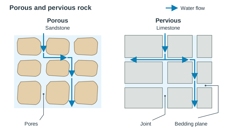
In contrast, an impermeable rock (such as shale or granite) does not allow water to pass through it. When surface rivers flow across impermeable bedrock, they remain on the surface. When they meet pervious limestone, water readily percolates downward along joints and bedding planes.
Chemical Weathering Processes
Chemical weathering breaks down rock by altering its chemical composition. Common processes include:
- Carbonation: weak acid in rainwater dissolves carbonate rocks. This is the dominant process in karst landscapes.
- Solution: soluble rock minerals dissolve directly into water without requiring an acid, such as rock salt.
- Hydrolysis: water chemically reacts with rock minerals. For example, feldspar in granite alters into soft china clay (kaolin), weakening the rock structure.
- Oxidation: oxygen dissolved in water or air reacts with iron minerals in rock, producing a crumbly, reddish-brown iron oxide similar to rust.
(Note: In exam questions asking you to explain one physical and one chemical weathering process, carbonation is frequently paired with freeze-thaw action.)
The Chemistry of Carbonation
Carbonation takes place in two clear steps:
- Rainwater absorbs carbon dioxide () from the atmosphere and from decaying organic matter in soil, forming weak carbonic acid:
- As this weak acid washes over the rock and trickles down its joints, it reacts with the insoluble calcium carbonate in the limestone, converting it into soluble calcium bicarbonate:
The dissolved calcium bicarbonate is carried away in solution. Over thousands of years, this continuous chemical removal widens structural weaknesses, carves surface channels, and hollows out extensive subterranean chambers.
Surface Karst Features: Pavements, Swallow Holes, and Turloughs
Surface karst is marked by bare rock platforms, deep fissures, sinking streams, and a lack of normal river networks.
Limestone Pavements
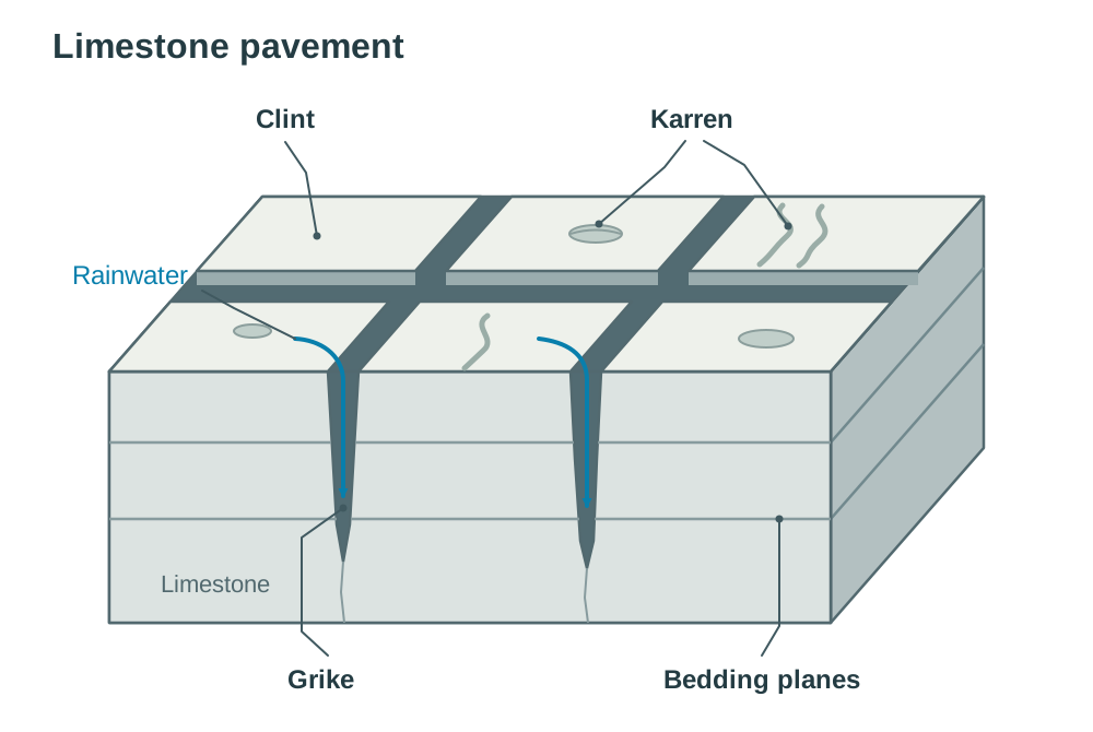
A limestone pavement is a large, flat sheet of bare rock divided into regular blocks by solution-widened cracks. During the last Ice Age, moving ice sheets scoured away soil and glacial deposits across the Burren, leaving the bare bedrock directly exposed to rain.
- Grikes: rainwater follows gravity down vertical joints. Carbonation dissolves the limestone walls along these fractures, widening and deepening them into deep fissures called grikes.
- Clints: the elevated, flat slabs of intact limestone left standing between neighbouring grikes are clints.
- Karren: small solution features on the surface of clints. Rainwater settling in shallow dips dissolves small hollows (pits and pans), while water running towards the edges carves small runnels. Deeper vertical grooves down the sides of clints are called fluting.
- Vegetation: grikes are sheltered, damp, and shaded, providing a microclimate where ferns like maidenhair fern and hart's-tongue fern thrive. On the open, sunny pavement and thin calcareous soils nearby, the Burren is famous for Arctic-alpine plants (such as mountain avens) growing alongside Mediterranean species (such as the dense-flowered orchid).
Diagram outline (Limestone pavement cross-section): draw a horizontal slab of rock cut by deep vertical gaps (grikes), leaving flat blocks on top (clints). Show horizontal lines running across (bedding planes) and shallow hollows on the surface (karren).
Swallow Holes and Dolines
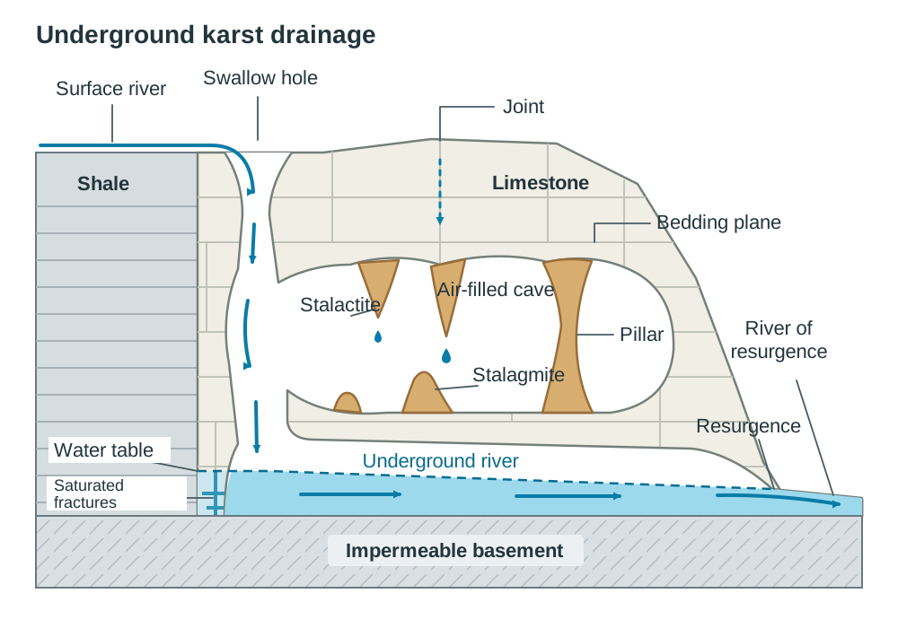
- Swallow holes (also called sluggas): funnel-shaped shafts where a surface river plunges underground. They often form at the geological boundary where a river flows off impermeable rock onto pervious limestone. For example, streams flowing off the impermeable shale cap of Slieve Elva in County Clare sink into swallow holes, such as Poll na gColm, which drops over 30 metres into an underground cave system.
- Dolines: closed circular or oval hollows on the surface. They can form by localised surface dissolution or when the roof of an underground cave collapses.
Dry Valleys and Turloughs
- Dry valleys: river valleys that no longer carry surface water because the river has been diverted underground through swallow holes.
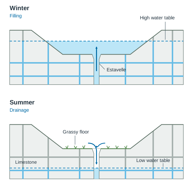
- Turloughs: seasonal lakes unique to lowland limestone areas, such as Rahasane Turlough in County Galway. They fill and empty through openings in their floor called estavelles. When the underground water table rises during wet winter months, water bubbles up from estavelles to flood the depression. In dry summer periods, the water table falls, and water drains back down the estavelles, leaving a grassy pasture.
Subterranean Landforms: Caves, Dripstones, and Resurgences
Underground karst landforms depend on groundwater levels and the movement of water through the rock.
The Water Table and Cave Excavation
- Percolation is the downward movement of water through soil and rock. In limestone, rainwater percolates down vertical joints and then moves along horizontal bedding planes.
- The groundwater table (or water table) is the upper level of the zone where the rock is permanently saturated with water (the zone of saturation). Below the water table, every crack is full of water; above it, fractures contain air and trickling water.
- In the formation sequence shown here, caves develop at or below the water table, where acidic water fills joints and bedding planes and dissolves the rock by carbonation. Once passages widen enough to carry flowing water, physical erosion speeds up the process: hydraulic action knocks loose joint blocks out with the force of moving water, and abrasion scours cave floors with carried sand and rock particles.
- When rivers cut deeper or the regional water table drops, passages drain and become air-filled caves, such as Aillwee Cave and Doolin Cave in County Clare.
Dripstones (Stalactites, Stalagmites, and Pillars)
Dripstones are depositional features formed inside air-filled caves by the reverse of the carbonation reaction.
Water carrying dissolved calcium bicarbonate trickles through joints in the cave ceiling. Cave air contains less carbon dioxide than the water drop, so some carbon dioxide escapes from the drop into the air, and a small amount of water evaporates. The water drop can no longer hold all its dissolved mineral, so a tiny speck of solid calcium carbonate (calcite) precipitates out:
- Stalactites: water droplets hanging from the ceiling deposit tiny rings of calcite before falling. Successive rings form a thin, hollow straw. Eventually, sediment blocks the centre, forcing water down the outside, thickening it into an icicle-shaped cone pointing downward from the roof. The Great Stalactite in Doolin Cave measures over 7 metres in length, making it one of the longest free-hanging stalactites in Europe.
- Stalagmites: water droplets fall from the roof onto the cave floor. The impact splashes the water outward, releasing carbon dioxide and depositing calcite across a wider, flat base. Over time, rounded, mound-like deposits build upward.
- Pillars: over thousands of years, a descending stalactite and an ascending stalagmite meet and fuse into a continuous vertical column extending from floor to ceiling.
Underground Rivers and Resurgences
An underground river flows through cave passages along the lower bedding planes. When the water reaches impermeable rock beneath the limestone, it cannot sink deeper. It flows along the impermeable floor until it reappears on the surface at a resurgence (a karst spring). The river that flows out is a river of resurgence.
Example: the Cladagh River emerges from the Marble Arch Caves system at the Marble Arch resurgence, beneath the Cuilcagh uplands in County Fermanagh.
Diagram outline (Cave cross-section): draw a surface river sinking into a swallow hole, leading down into an underground cavern. Show stalactites hanging from the ceiling, stalagmites on the floor, and a pillar where they join. Draw the water table and show the underground river flowing along an impermeable basement layer to exit at a resurgence.
The Burren as a Geomorphological Region and Karst Evolution
A geomorphological region is an area defined by its shared relief, rock type, and landforms. The syllabus names karst landscapes as a type of geomorphological region. The Burren in north-west County Clare is the classic Irish example.
Human Interaction in the Burren
The distinctive limestone landscape directly influences human activities:
- Farming: soils are thin or absent, but limestone retains summer heat into the colder months. Local farmers use an ancient practice called winterage, moving cattle up to the limestone hills to graze dormant grasses through the winter.
- Tourism: the bare upland scenery, historical monuments like Poulnabrone portal tomb, show caves like Aillwee Cave, and unusual botanical species attract hundreds of thousands of visitors every year, sustaining local employment.
- Water contamination risk: because limestone is pervious, surface water bypasses natural soil filtration and drains directly down joints into the groundwater. Agricultural slurry, synthetic fertilisers, and domestic septic-tank leaks can quickly contaminate drinking-water aquifers and resurgence springs, making careful environmental management essential.
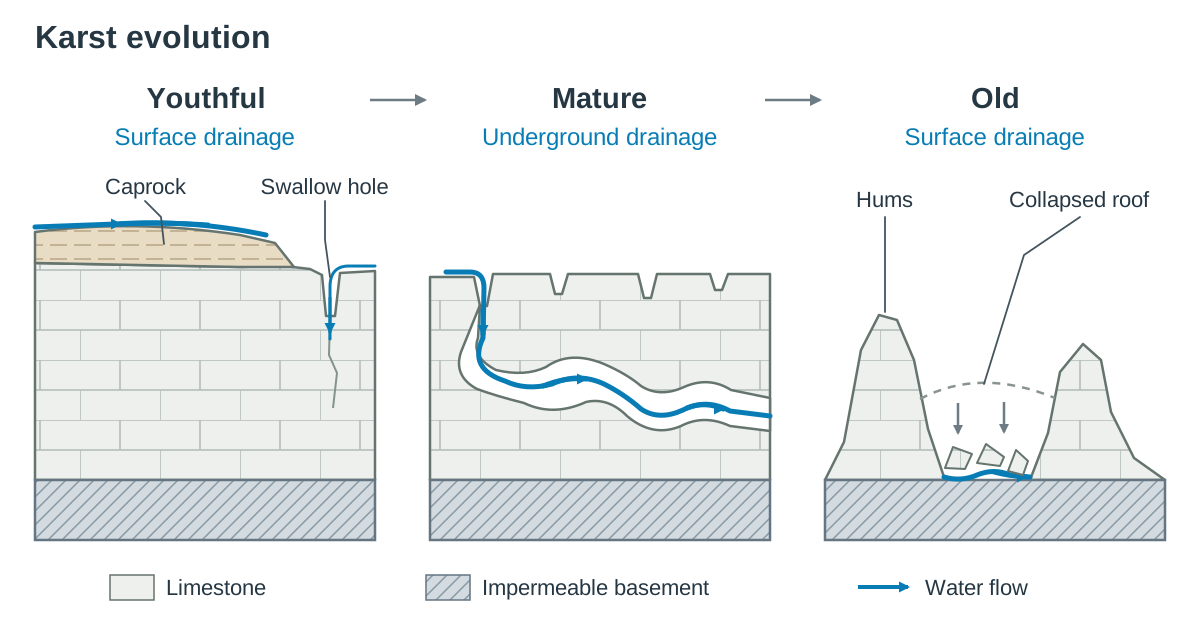
Stages of Karst Landscape Evolution
Karst landscapes change over millions of years through three distinct stages:
| Stage | Drainage Pattern | Typical Landforms | Named Examples |
|---|---|---|---|
| Youthful | Surface drainage dominates; rivers flow across an overlying layer of impermeable rock or soil. | Initial stripping of caprock; carbonation begins on exposed joints; swallow holes start to capture minor streams. | Shale boundaries on Slieve Elva (Clare) and the Cuilcagh uplands (Fermanagh) |
| Mature | Underground drainage dominates; nearly all rivers have disappeared below ground. | Extensive bare limestone pavements with clints and grikes; dry valleys; deep cave and cavern networks; turloughs; water re-emerges at resurgences. | The Burren, Co. Clare |
| Old | Surface drainage returns as cave roofs collapse and rivers cut down to impermeable rock below. | Cave roofs have fallen in; most limestone has been dissolved; isolated, steep-sided residual limestone hills remain. | General residual hills are called hums. In tropical climates with high rainfall, they form sheer towers known as tower karst, seen in Guilin, southern China. |
Other notable international karst regions include Mammoth Cave in Kentucky, USA (the longest known cave system in the world) and the Kras plateau in Slovenia (the classic karst terrain from which the landscape gets its name).
Key terms
- Carbonation
- A process of chemical weathering where weak carbonic acid in rainwater reacts with calcium carbonate in rocks like limestone, dissolving it into soluble calcium bicarbonate.
- Permeable Rock
- A rock that allows water to pass through it, either through tiny pore spaces (porous) or along open joints and cracks (pervious).
- Pervious Rock
- A rock that allows water to pass along cracks, joints, and bedding planes rather than through pore spaces between grains, such as limestone.
- Joint
- A natural vertical fracture in rock strata caused by drying, contraction, or tectonic stress, which acts as a route for water percolation.
- Bedding Plane
- A natural horizontal line of separation in sedimentary rock that divides one layer of deposited sediment from another.
- Limestone Pavement
- A large, bare horizontal surface of exposed limestone bedrock cut into a network of blocks and fissures by chemical weathering.
- Clint
- A flat-topped, elevated block of limestone on a pavement, separated from neighbouring blocks by deep vertical fissures.
- Grike
- A deep vertical fissure separating the clints on a limestone pavement, formed when rainwater widens a natural joint by carbonation.
- Karren
- Small solution features on the surface of clints, including shallow hollows (pits) and small runoff runnels.
- Swallow Hole
- A funnel-shaped opening where a surface river plunges underground into a limestone fracture network.
- Doline
- A closed, circular or oval hollow on a karst surface formed by localised carbonation or the collapse of an underlying cave roof.
- Turlough
- A seasonal lake in lowland karst areas that floods in wet winter periods when the water table rises and drains away in dry summers.
- Groundwater Table
- The upper surface of the zone of saturation, below which all pores, joints, and cracks in rock or soil are completely filled with water.
- Percolation
- The downward movement of water through pores, joints, and fissures in soil or rock.
- River of Resurgence
- A river that flows back out onto the surface from an underground karst cave network.
- Stalactite
- An icicle-shaped dripstone of calcite that hangs downward from the ceiling of an air-filled limestone cave.
- Stalagmite
- A thick, rounded mound of calcite built upward from a cave floor where mineral-rich water drops splash.
- Pillar
- A continuous vertical rock column formed when a descending stalactite meets and joins an ascending stalagmite.
- Hums
- Isolated, residual limestone hills left standing on impermeable bedrock in the old stage of karst landscape evolution.
- Tower Karst
- Dramatic, steep-sided limestone towers left behind in tropical karst landscapes (such as Guilin, China) during the old stage of evolution.
Check yourself
What is meant by a permeable rock, and why is limestone considered pervious rather than porous?
A permeable rock allows water to pass through it. Limestone is pervious because water travels through cracks (vertical joints and horizontal bedding planes) rather than soaking through tiny pore spaces between grains.
Name two processes of chemical weathering other than carbonation.
Any two from: hydrolysis, oxidation, or solution.
True or False: 'A river of resurgence is one that disappears underground.'
False. A river disappears underground down a swallow hole; a river of resurgence comes back out onto the surface.
What is the groundwater table, and how does its movement create a seasonal turlough?
The groundwater table is the upper surface of the zone of rock permanently saturated with water. In wet winters it rises above the ground, flooding low depressions through estavelles, and in dry summers it falls, allowing water to drain back underground.
Identify the two features labelled X and Y on a limestone pavement cross-section where X is a flat surface slab and Y is a deep vertical crack.
X is a clint and Y is a grike.
What is the difference between general hums and tropical tower karst in the old stage of karst evolution?
Hums are small, isolated residual limestone hills left on impermeable rock after surrounding limestone has dissolved. Tower karst is the dramatic, steep-sided tropical form found in places like Guilin, southern China.