

A glacier is a massive, slow-moving river of ice that acts as a powerful agent of landscape change. It cuts into bedrock through erosion, carries huge volumes of rock debris across country, and dumps that load when the climate warms and the ice melts. During the Quaternary ice ages, large ice sheets reshaped Ireland's mountains and lowlands, carving deep upland troughs and spreading thick blankets of unsorted till and sorted sand and gravel over the plains. For Leaving Certificate Higher Level Geography, you must explain the physical mechanics of erosion, transportation, and deposition, clearly distinguish between direct ice deposits and fluvioglacial sediments, recognize these features on Ordnance Survey maps, and write detailed 30-mark answers supported by named Irish case studies and clear diagrams.
Glacial Ice Movement, Budget, and Processes of Erosion
Glaciers begin on mountain slopes where winter snowfall regularly exceeds summer melt. Over decades, accumulating layers press down on the older snow below, squeezing out trapped air. This snow compacts into granular névé (firn) and turns into dense blue glacial ice.
The Glacial Budget
A glacier works on an input-output system known as the glacial budget. Accumulation is the input, taking in new ice from snowstorms, avalanches, and frost refreezing in the high, cold zone of accumulation. Ablation is the output, losing mass through melting, evaporation, and calving down at the lower snout in the zone of ablation.
When accumulation outpaces ablation, the glacier holds a positive budget and advances down its valley. If melting exceeds snowfall, the glacier runs a negative budget and retreats up-valley. When both match, the snout stands still. Even with a stationary snout, ice does not sit idle. It continually flows downhill like a giant conveyor belt, dumping rock debris at its front edge to build a terminal or recessional ridge.
Calculating snout movement: Suppose a glacier snout retreats 540 metres between 2006 and 2015. Count the elapsed time first: . Then divide distance by time: . Subtracting the calendar years first avoids miscounting the period as ten years.
How Ice Moves
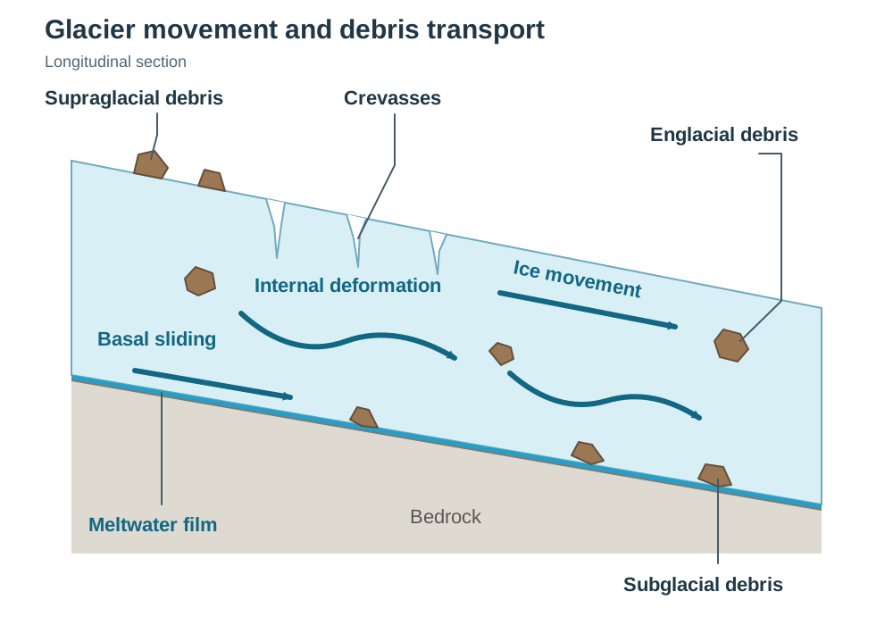
Gravity drags glacial ice downslope by two main mechanisms:
- Basal sliding: Under temperate glaciers, the massive weight of the ice lowers the melting point at its base. This pressure melting creates a thin film of water that lubricates the valley floor, letting the entire ice mass slide bodily over bedrock.
- Internal deformation: In the deeper parts of a glacier (generally below 50 metres), enormous confining pressure forces individual ice crystals to change shape and slide past one another. The ice creeps forward like thick, cold plastic. Near the surface, where confining pressure is light, the ice remains brittle, cracking open under tension to create deep crevasses.
Processes of Erosion
- Plucking: Meltwater beneath the glacier enters joints and bedding planes in the bedrock and refreezes around loose blocks. As the glacier shuffles forward, it tears these shattered blocks out of the bedrock floor and sides, leaving behind a jagged, fractured surface. Freeze-thaw weathering on exposed cliffs above also drops rock fragments down onto the ice, feeding the moving glacier with fresh ammunition.
- Abrasion: Plucked boulders and angular stones frozen into the glacier base act like coarse sandpaper against the valley floor. Heavy boulders gouge long parallel scratches called striations into bedrock, which show geologists the exact path the ice took. Finer particles scour and polish the rock, grinding the debris down into a fine rock flour that turns meltwater rivers a cloudy, milky grey.
Factors Influencing Glacial Erosion
- Ice thickness and gradient: Deeper ice exerts heavier pressure on the bed, increasing sliding speeds and erosive bite. Steeper valley gradients speed up the downhill flow, focusing more kinetic energy into the valley floor.
- Bedrock structure: Well-jointed sedimentary rocks, like the Old Red Sandstone of the MacGillycuddy's Reeks in Co. Kerry, were readily plucked along joint planes. By contrast, massive crystalline rocks with few fractures, such as sections of the Leinster granite batholith in Co. Wicklow, resisted plucking and were mainly smoothed down by abrasion.
Landforms of Glacial Erosion
Glacial erosion turns rolling river landscapes into dramatic, angular mountain country.
Cirques (Corries or Cooms)
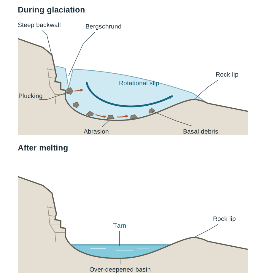
A cirque is an armchair-shaped mountain hollow with three steep rock walls, an over-deepened basin floor, and a raised rock lip across its front. In Ireland, snow accumulated in small pre-existing stream hollows on sheltered north- and north-east-facing slopes, away from direct sunlight. Freeze-thaw shattering around the snow patch (nivation) widened and deepened the hollow. As the snow compacted into ice, the small glacier began to rotate downhill under gravity through rotational slip.
As the ice pulled away from the headwall, a gaping crevasse called a bergschrund opened. Freeze-thaw weathering attacked the exposed cliff above, dropping angular rock fragments into the bergschrund. Subglacial meltwater froze into rock joints, and plucking tore rock away to leave a vertical cliff. At the same time, boulders caught in the base ground down the hollow floor through abrasion. Because rotational force peaked near the centre of the hollow, the glacier dug a deep rock basin while leaving a raised rock lip at the threshold. When the ice melted, rain and meltwater filled the depression behind the lip to form a tarn. The Devil's Punchbowl on Mangerton Mountain, Co. Kerry, and Lough Nahanagan, Co. Wicklow, are textbook Irish examples.
Associated Cirque Features
- Arête: A knife-edged rock ridge formed when two neighbouring cirques erode backwards towards each other from opposite sides of a mountain ridge. A well-known Irish example is the ridge between Carrauntoohil and Beenkeragh in Co. Kerry.
- Pyramidal peak: A sharp, horn-shaped mountain peak formed when three or more cirques cut backwards into the same mountain core. Carrauntoohil, Ireland's highest peak, is a classic example.
Glaciated Valleys (U-Shaped Valleys or Troughs)
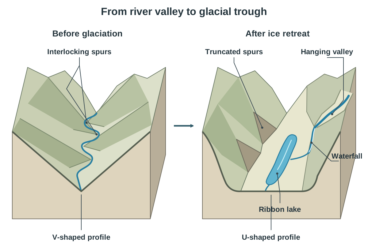
Valley glaciers naturally follow existing V-shaped river valleys because they offer the easiest path downslope. A thick, rigid glacier cannot twist around interlocking river spurs. Instead, it shears straight through their ends by plucking and abrasion, leaving triangular cliffs known as truncated spurs. Downward and sideways erosion widens the valley floor and steepens the walls, converting the narrow V-notch into a broad U-shaped trough.
Features within Glaciated Valleys
- Hanging valley: A tributary valley that held a smaller tributary glacier during the ice age. Because this side glacier had far less mass and erosive power, it could not cut down as deeply as the main trunk glacier. When the ice retreated, the tributary valley floor was left perched high above the main glaciated floor. Streams from these valleys cascade down the steep cliffs as waterfalls, like Poulanass Waterfall at Glendalough, Co. Wicklow.
- Ribbon lake: A long, narrow lake on a valley floor. It fills an elongated rock basin scoured out by abrasion where the bedrock was fractured or where ice was particularly thick. It can also be dammed behind a moraine. Examples include the Upper Lake at Glendalough and Lough Dan in Co. Wicklow.
- Paternoster lakes: A sequence of small rock-basin lakes along a glaciated valley linked by a single stream, looking like beads on a rosary.
- Fiord: A deeply scoured glacial trough flooded by post-glacial sea level rise. Killary Harbour, on the Galway–Mayo border, is Ireland's best-known fiord, stretching inland for 16 kilometres.
Roche Moutonnée
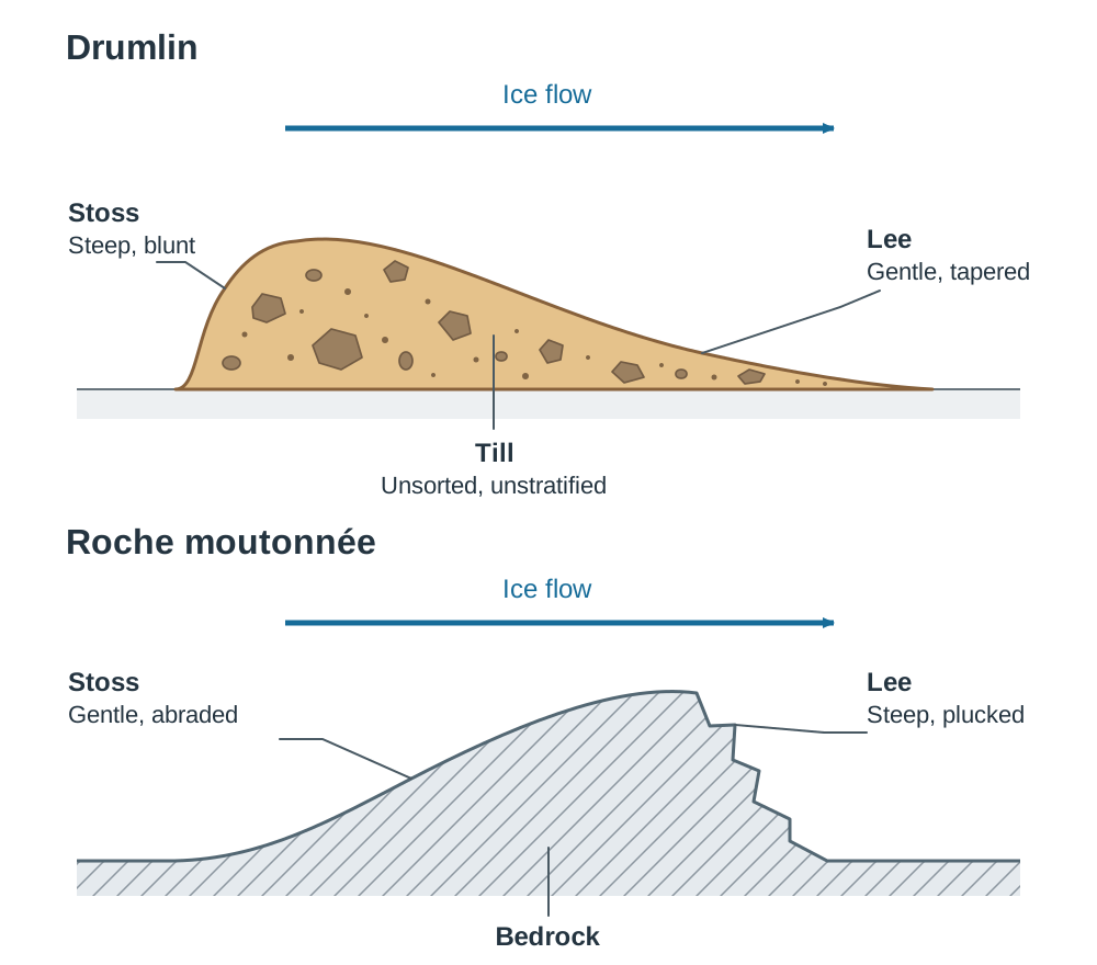
A roche moutonnée is an asymmetrical bedrock hill on a valley floor, sculpted by passing ice. Its up-ice side (stoss end) is gently sloping, polished, and striated where the glacier rode up over it and ground it down by abrasion. Its down-ice side (lee end) is steep and jagged because dropping pressure allowed meltwater to refreeze into joints, tearing blocks away by plucking. Roches moutonnées reveal the historical path of ice movement and can be seen on the valley floors of Glendalough, Co. Wicklow, and Killarney, Co. Kerry.
Glacial Transportation and Depositional Till Landforms
Ireland experienced two main glaciations during the Pleistocene: the older Munsterian glaciation, which blanketed almost the entire island, and the more recent Midlandian glaciation, which covered the northern two-thirds. The southern boundary of the Midlandian ice is marked by the South Irish End Moraine, which runs across the country from southern Co. Wicklow through the Curragh towards the mouth of the Shannon.
Transported Debris Zones
- Supraglacial debris: Rock fragments carried on the glacier surface, supplied by freeze-thaw weathering and rockfalls tumbling from valley walls.
- Englacial debris: Sediment carried within the body of the ice, which occurs when surface debris drops down crevasses or gets buried by new snow in the accumulation zone.
- Subglacial debris: Material dragged along the base of the ice, made up of plucked bedrock chunks and pulverised rock flour.
Glacial Till (Boulder Clay)
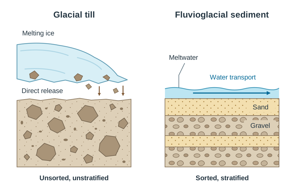
Material dropped directly by melting ice is known as glacial till or boulder clay. Because it falls out of the ice without running water to sort it, it is unsorted and unstratified. You will find tiny clay particles and multi-tonne boulders mixed together in a single chaotic deposit.
Moraines
- Lateral moraine: Ridges of unsorted rock scree and plucked debris dumped along the sides of a valley glacier where the ice met the rock walls.
- Medial moraine: A debris ridge running down the middle of a glaciated valley floor, formed when two tributary glaciers join and their inner lateral moraines merge.
- Terminal moraine: A prominent ridge of till dumped across a valley or lowland plain marking the furthest forward point of an advancing glacier, formed when forward ice movement matches the rate of melting at the snout.
- Recessional moraine: A transverse ridge deposited behind the terminal moraine during a temporary pause in an overall phase of glacial retreat.
- Ground moraine: A broad blanket of boulder clay smeared across the landscape beneath a melting ice sheet, creating fertile, rolling lowlands like the Central Plain of Ireland.
Drumlins
Drumlins are streamlined, oval hills of compacted boulder clay sculpted beneath an active ice sheet. They show a clear asymmetrical profile:
- Stoss end: A steep, blunt up-glacier slope that points towards the direction from which the ice advanced.
- Lee end: A gentle, tapered tail pointing in the direction towards which the ice was travelling.
Drumlins formed when a moving ice sheet became overloaded with subglacial sediment or encountered an obstinate bedrock knoll. The glacier dumped excess till and smoothed the clay beneath it into a low-drag, streamlined teardrop shape. Drumlins appear in swarms, giving rise to a basket of eggs topography. A vast drumlin belt stretches across south Ulster and north Connacht through Cavan and Monaghan to Clew Bay, Co. Mayo, where rising sea levels drowned the swarm to form an archipelago of small islands.
Glacial Erratics
An erratic is a large boulder carried by ice over tens or hundreds of kilometres and dropped on bedrock of completely different geology. For example, granite boulders carried from Connemara sit perched on the bare Carboniferous limestone pavements of the Burren, Co. Clare.
Fluvioglacial Processes and Meltwater Landforms
Landforms created by glacial meltwater are classed as fluvioglacial. Because these sediments are transported and dropped by running water rather than direct ice, they are sorted by size and stratified into distinct horizontal layers.
Eskers
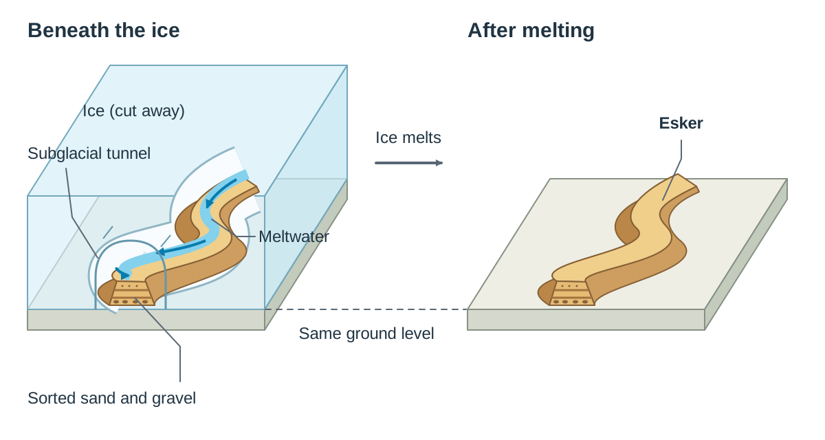
An esker is a long, winding ridge of sorted sand and gravel that snakes across lowland plains. Eskers formed in subglacial tunnels beneath stagnant, decaying ice sheets. Confined meltwater streams flowed through these tunnels under high hydrostatic pressure, carrying heavy sediment loads. As the ice melted and water velocity slowed, the streams lost competence, dropping coarse gravel at the base and finer sands higher up. When the surrounding ice walls melted away entirely, the sediment bed remained behind as an elevated winding ridge. The Eiscir Riada is a celebrated series of eskers crossing the country from Dublin to Galway, historically providing dry east-west travel across wet midland bogs.
Outwash Plains, Kames, and Kettle Holes
- Outwash plain (sandur): A flat or gently sloping plain of sorted sand and gravel spread out in front of a terminal moraine. Braided meltwater streams escaping the snout lose velocity quickly, dumping coarse gravel near the ice front and washing finer sands further down-valley. The Curragh in Co. Kildare is an outwash plain covering around 2,000 hectares.
- Kettle hole: A circular hollow on an outwash plain. It formed when a stagnant ice block became buried under outwash gravels. When the ice block finally melted, the gravel collapsed into the empty space. Some kettle holes fill with water to form small, round kettle lakes. The Curragh has dry hollows that are usually explained as kettle holes.
- Kame: A small, steep-sided mound of sorted sand and gravel. It formed when meltwater washed sediment into crevasses or depressions on the surface of stagnant ice, dropping to the valley floor as the ice wasted away.
- Glacial spillway: A deep, steep-sided gorge eroded when a lake dammed behind ice or a moraine overflowed a low col. Torrential meltwater carved a deep channel through hydraulic action and abrasion. Today, these valleys are often occupied by tiny misfit streams. The Glen of the Downs in Co. Wicklow and the Scalp in Co. Dublin are classic Irish examples.
Summary Classification of Landforms
| Origin | Process | Landforms |
|---|---|---|
| Glacial Ice | Erosion | Cirque, tarn, arête, pyramidal peak, U-shaped valley, truncated spur, hanging valley, ribbon lake, fiord, roche moutonnée, striations |
| Glacial Ice | Deposition | Moraines (lateral, medial, terminal, recessional, ground), drumlin, erratic, till plain |
| Meltwater | Fluvioglacial Deposition | Esker, outwash plain, kame, kettle hole |
| Meltwater | Fluvioglacial Erosion | Glacial spillway |
Key terms
- Plucking
- A process of glacial erosion where subglacial meltwater freezes onto jointed bedrock, and as the glacier moves forward, it pulls shattered rock fragments away.
- Abrasion
- The mechanical wearing away of bedrock by rock fragments and boulders embedded within the basal layer of a moving glacier.
- Striations
- Parallel grooves and scratches carved into exposed bedrock surfaces by coarse stones dragged along in the base of a glacier, recording ice-flow direction.
- Basal sliding
- The movement of a temperate glacier sliding bodily over its bedrock floor, facilitated by a thin film of pressure-melted water.
- Internal deformation
- The slow plastic flow of glacial ice deep within a glacier, where individual ice crystals change shape and slide over one another under intense overburden pressure.
- Cirque
- An armchair-shaped mountain hollow with steep plucked rock walls, an over-deepened basin scoured by rotational ice slip, and a raised rock lip.
- Bergschrund
- A deep tension crevasse opening near the headwall of a cirque where the moving glacier pulls away from the stationary ice attached to the rock wall.
- Arête
- A sharp, knife-edged mountain ridge formed between two adjacent cirques eroding headward towards each other.
- Pyramidal peak
- A sharp, pointed mountain peak created when three or more cirques erode backwards into the same mountain core.
- Truncated spur
- A steep, triangular cliff on a glaciated valley wall formed where a valley glacier planes off the ends of pre-existing interlocking river spurs.
- Hanging valley
- A tributary valley left perched high above the floor of a main glaciated trough because its smaller tributary glacier had less erosive downcutting power.
- Ribbon lake
- A long, narrow lake occupying an over-deepened rock basin scoured out by abrasion on a valley floor or impounded behind a moraine dam.
- Roche moutonnée
- An asymmetrical bedrock outcrop with a smooth, striated up-ice stoss slope formed by abrasion and a steep, jagged down-ice lee face formed by plucking.
- Boulder clay (glacial till)
- Unsorted and unstratified sediment deposited directly by melting ice, containing a jumbled mixture ranging from fine clay to massive boulders.
- Terminal moraine
- A prominent ridge of unsorted till deposited across a valley or lowland marking the furthest forward advance of a glacier or ice sheet.
- Drumlin
- A streamlined, oval hill of compacted boulder clay featuring a steep, blunt stoss end pointing up-glacier and a gentle, tapered lee end pointing down-glacier.
- Glacial erratic
- A large rock boulder deposited by melting ice in an area whose local bedrock is of a completely different geological type.
- Esker
- A long, sinuous ridge of sorted and stratified sand and gravel deposited by a meltwater stream flowing in an enclosed subglacial tunnel.
- Outwash plain
- A broad, flat or gently sloping plain of sorted sand and gravel deposited by braided meltwater streams in front of a retreating glacier's terminal moraine.
- Kettle hole
- A circular depression on an outwash plain formed when an ice block buried in outwash gravels melted, causing the overlying sediment to collapse.
- Kame
- A small, irregular mound of sorted sand and gravel deposited in crevasses or hollows on melting stagnant ice.
- Deranged drainage
- An irregular, disorganised stream network with numerous bogs and small lakes, common on uneven glacial till and drumlin landscapes.
Check yourself
Indicate whether each of the following four landforms is most associated with glacial erosion, glacial deposition, or fluvioglacial processes: Erratic, Cirque, Drumlin, Outwash plain.
Erratic: Glacial deposition; Cirque: Glacial erosion; Drumlin: Glacial deposition; Outwash plain: Fluvioglacial processes.
Explain briefly what happens during the glacial erosion process of plucking.
Subglacial meltwater at the base or sides of the glacier freezes onto jointed bedrock, and as the glacier advances downhill, the ice pulls the rock fragments away with it.
What is the primary physical difference between glacial till (boulder clay) and fluvioglacial deposits?
Boulder clay is unsorted and unstratified because it is dumped directly by ice; fluvioglacial material is sorted by particle size and stratified (layered) by flowing meltwater.
Under what glacial budget condition does a glacier snout advance down-valley?
A glacier advances when accumulation (snowfall/ice gain) exceeds ablation (melting/ice loss).
How do the stoss and lee slopes of a roche moutonnée differ in both appearance and formative process?
The stoss slope is gentle, smooth, and striated due to abrasion as ice rides up it; the lee slope is steep, rough, and jagged due to plucking as ice pulls away.
What evidence on a 1:50,000 OS map indicates an area of drumlins with deranged drainage?
Clusters of small, oval-shaped closed contour loops aligned in the same direction, interspersed with small lakes, bogs, and irregular, meandering streams in the hollows.