

Dynamics of Settlement explores why settlements develop where they do, how their forms and layouts change across countryside and towns, and how they serve surrounding populations. Under Elective Unit 5 of the Leaving Certificate syllabus, this topic centres on site and situation, the historical evolution of settlement in Ireland from prehistoric times to planned modern towns, distinct rural settlement patterns, rural planning policies, functional change over time, and Walter Christaller's Central Place Theory.
Site and Situation: Physical and Geographic Controls
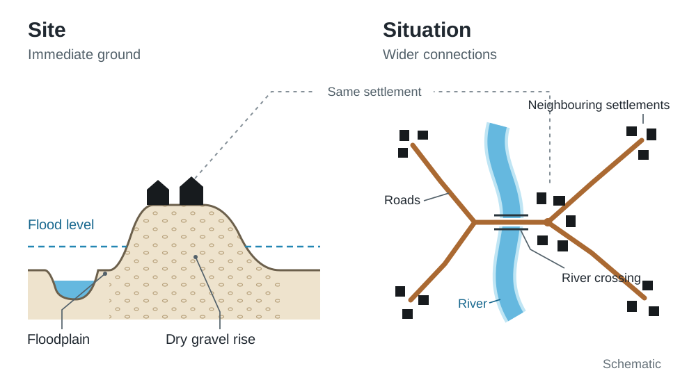
We explain where a settlement is using two ideas: its site (the physical ground it is built on) and its situation (where it is in relation to the surrounding area and transport networks).
Site Factors
Site describes the immediate physical ground of a settlement:
- Relief and Altitude: Lowland areas below 200 metres with flat or gently undulating ground make it much easier to build houses, lay roads, and farm. Steep upland slopes make building expensive and suffer harsher weather.
- Water Supply: Early settlements needed fresh water for drinking, cooking, and powering watermills. For example, settlements grew up along the River Suir or the River Nore.
- Bridging Point: A point where a river is shallow or narrow enough to be crossed by a ford or bridge naturally draws routes together (e.g. Carrick-on-Suir on the Suir, or Athlone on the Shannon).
- Dry Point Site: Elevated, well-drained gravel ridges or knolls on a floodplain keep homes above flood levels while keeping access to water (e.g. Athlone on raised gravel hills above the Shannon callows).
- Aspect: South-facing slopes receive more direct sunlight than north-facing slopes, giving them warmer temperatures and better crop-growing conditions.
- Defence: Natural barriers such as high hills, river loops, or coastal headlands protected early settlers from attack (e.g. Athlone Castle guarding the Shannon crossing, or the Rock of Cashel on a limestone outcrop).
Situation Factors
Situation describes a settlement's position relative to its wider region, neighbouring towns, and routeways. While site helps decide where the first homes are built, situation determines whether a settlement grows into a major city or stays a small village:
- Natural Routeways: Gaps through mountain ranges, river valleys, and estuaries form natural corridors for movement (e.g. the Barnesmore Gap in Donegal or the Munster Blackwater valley).
- Route Focus / Nodal Point: A town where several roads, motorways, or rail lines meet becomes a hub for retail, distribution, and commuting workers.
Case Study: Kenmare, Co. Kerry
Kenmare shows how site and situation work together:
- Site: Built on gently sloping lowland below 50 metres elevation on the northern bank of the Kenmare River estuary, shown on OS maps by widely spaced contour lines. The river supplied fresh water, fish, and rich alluvial soils, while the sheltered low ground avoided the exposed mountain terrain above 200 metres to the north and south.
- Situation: Kenmare grew into a key market town and tourist base because it sits at a nodal point where national routes N70 (Ring of Kerry) and N71 (linking to West Cork) meet regional roads R569 and R571. This connects the Iveragh and Beara peninsulas to Killarney and Cork.
OS Map Evidence: Site and Situation
When an exam question asks for map evidence of site or situation, name the feature, give a grid reference with the sub-zone letter, and explain the reason:
- Lowland relief (site): V 91 70 – widely spaced contours below 50 m show flat lowland that is easy to build on.
- Water access (site): V 912 709 – the town sits directly along the riverbank, giving access to fresh water and drainage.
- Route focus (situation): V 913 712 – the junction of the N70, N71, and regional roads shows nodality, allowing the town to serve the surrounding district.
Historical Evolution of Irish Settlement
The Irish landscape shows layers of settlement: each period of history has left features that we can still find on OS maps today.
Prehistoric Settlement
- Mesolithic (c. 7000–3500 BC): Nomadic hunter-gatherers left little structural evidence. Their presence is shown mainly by coastal and riverine middens (refuse mounds of shells, animal bones, and flints near water).
- Neolithic (c. 3500–2000 BC): Ireland's first settled farmers cleared forests to grow crops and raise livestock. They built permanent timber and wattle-and-daub farmsteads. Surviving evidence consists of stone megalithic tombs: passage tombs (e.g. Newgrange in the Boyne Valley, aligned to the winter solstice sunrise), portal dolmens, and court tombs.
- Bronze Age (c. 2000–600 BC): Metalworkers used copper and tin, living near mineral deposits or river valleys. Burial sites include wedge tombs, cist graves, and stone circles. Domestic settlement evidence is dominated by fulachtaí fia (ancient cooking places, marked on OS maps with the label 'Fulacht Fia', usually beside streams or marshy ground).
Historic Settlement
- Celtic / Iron Age (c. 600 BC–500 AD): A decentralised tribal society organised into kingdoms (tuatha). Families lived in dispersed farmsteads enclosed by circular earthen banks (ráth, lios) or drystone walls (caiseal, cathair) to safeguard cattle from raiders. Crannógs – artificial islands built of timber, stone, and brushwood in shallow lakes, with a dwelling on top – provided defensive refuges.
- Early Christian (c. 500–1100 AD): Monasteries acted as Ireland's first proto-urban centres. Monks originally chose quiet, remote locations for prayer (e.g. Glendalough, Clonmacnoise), but these sites grew into centres of craft, trade, and learning. OS map clues include round towers, high crosses, stone churches, graveyards, holy wells, and cill / kill place names (e.g. Kilkenny, Kildare).
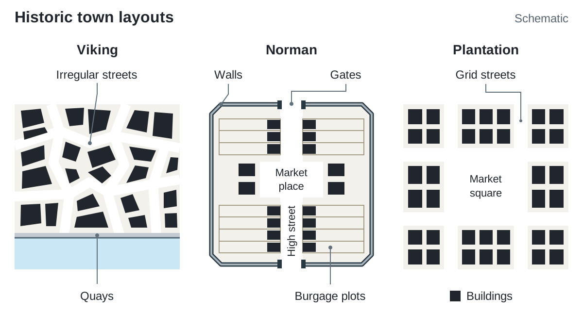
- Viking (c. 800–1169 AD): Scandinavian traders and raiders founded Ireland's first true maritime towns at sheltered estuaries, mainly on the east and south coasts (Dublin, Wexford, Waterford, Cork) and on the Shannon estuary (Limerick). They were fortified trading ports with narrow, irregular streets running down to quays. Place names ending in -ford (fjord) or -low trace this network.
- Norman (1169 AD onwards): Anglo-Normans introduced stone fortifications and formal feudal town planning. They built motte-and-bailey earthworks and stone castles at river crossings (e.g. Kilkenny, Trim). Norman towns featured defensive stone walls, guarded gates, a linear high street, a central market place, and burgage plots. OS map markers include castles, mottes, town walls, abbeys, and place names ending in -town (Castletown, Johnstown) or derived from Norman families (Butlerstown, Rochestown).
- Plantation Towns (1550–1700 AD): Planned towns established during English and Scottish colonial plantations in Laois, Offaly, Munster, and Ulster. Built for defence and commerce, they feature wide, straight streets arranged in a grid pattern around a central open market square or diamond (e.g. Derry with its diamond and defensive walls, Donegal town, and Bandon).
- Estate (Landlord) Towns (18th–19th Century): Wealthy landlords laid out or rebuilt planned towns beside their demesnes. Features include wide, straight streets, central squares or octagons, tree-lined malls, uniform Georgian terraces, and market houses. Examples include Westport, Co. Mayo (planned by the Browne family of Westport House, featuring the tree-lined Mall along the Carrowbeg River and the Octagon), Birr, Co. Offaly (Georgian streets planned around Birr Castle), and Adare, Co. Limerick (remodelled as an estate village by the Earls of Dunraven).
- New Towns (1960s onwards): Planned satellite towns. Dublin's new towns (Tallaght, Blanchardstown, Lucan–Clondalkin) were built from the late 1960s to house the capital's growing population and contain unmanaged urban sprawl. Shannon, Co. Clare, was purpose-built from the 1960s to house workers for Shannon Airport and the Shannon Free Zone industrial estate.
OS Map Evidence of Historic Settlement
Always give the sub-zone letter first, then the easting and northing:
- Prehistoric: a standing stone at W 123 456 or a fulacht fia beside a stream at W 128 459 indicates Bronze Age activity near fresh water.
- Celtic / Early Christian: a ringfort (marked as "Ráth", "Lios", or a red circle) at W 134 467 shows an isolated farmstead on well-drained lowland. An abbey, graveyard, and place names with Kil- at W 142 470 point to Early Christian monastic settlement.
- Norman: a castle and motte guarding a river bridging point at W 151 475 demonstrate Norman military and trade control.
- Estate / Plantation: a large demesne with estate walls, mixed woodland, and a planned grid street pattern at W 155 480 shows landlord settlement.
Rural Settlement Patterns and Rural Planning Challenges
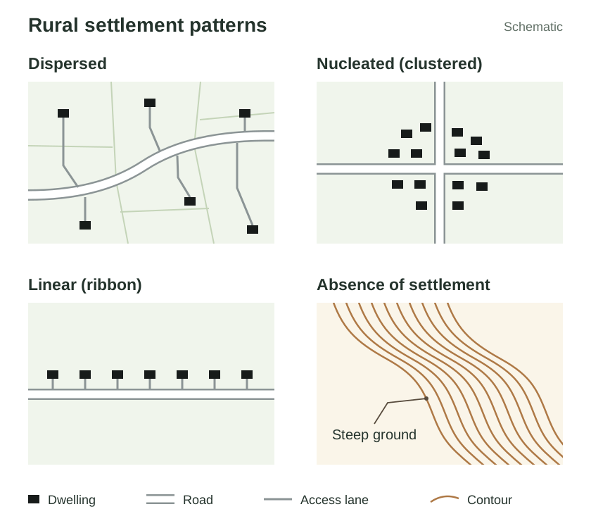
Rural settlement patterns describe how houses, farmsteads, and outbuildings are laid out across the countryside.
| Pattern | Visual Layout | Primary Causes in Ireland | OS Map Clues |
|---|---|---|---|
| Dispersed | Standalone farmsteads and houses scattered across open farmland. | Rundale clusters (clachans) were broken up in the 19th and early 20th centuries after the Famine. The Land Acts (1870–1903) made tenant farmers owners of their land, and the Congested Districts Board and Land Commission consolidated scattered strips into compact farms, prompting families to build houses directly on their own land. | Individual black building symbols scattered along third-class and local roads with private driveways. |
| Nucleated (Clustered) | Houses grouped closely together into a hamlet or village. | Clustered around historic focal points: river bridges, church sites, crossroads, landlord estate gates, or surviving fishing ports. | Dense grouping of house symbols around a central road junction, church, school, or green. |
| Linear (Ribbon) | Houses built in a continuous single row along a roadway. | Subdivision of road-frontage farm sites from the 1960s onwards; easy connection to roadside electricity, telephone lines, and group water mains without constructing private access roads. | Continuous line of residential house symbols directly flanking regional or national roads running out of a town. |
| Absence of Settlement | Large tracts of countryside containing no dwellings. | Severe physical obstacles: waterlogged blanket bogs, low-lying river floodplains (callows), steep upland slopes (>200 m), or bare karst limestone. | Blank areas showing close contour lines, marsh symbols, peat cuttings, or commercial conifer forests. |
The Rural Planning Debate in Ireland
Since the late 20th century, counter-urbanisation (the movement of people from cities and large towns into the countryside) has put heavy pressure on rural areas, especially within commuter belts.
Problems of One-Off Housing and Ribbon Development
- Traffic Congestion and Road Safety: Multiple private driveways opening directly onto high-speed national and regional roads create blind exits, interrupt traffic flow, and raise collision risks.
- Water Contamination: Scattered one-off houses rely on private septic tanks. In areas with poorly draining clay soils or permeable limestone bedrock, malfunctioning septic tanks leak effluent into aquifers, contaminating local well water with nitrates and bacteria.
- High Infrastructure Costs: Supplying electricity, rural broadband, postal delivery, school transport, and road resurfacing to scattered dwellings costs councils far more per household than servicing houses in nucleated villages.
- Landscape Degradation: Lines of modern suburban bungalows erode the open scenic quality of the countryside, damaging rural tourism and wildlife habitats.
Planning Policy Responses
- County Development Plans: Drawn up by each local authority, these plans zone land and lay down planning rules. In designated "rural areas under strong urban influence", an applicant must prove a genuine local housing need (such as working full-time in farming or having long-standing family ties to the immediate rural community).
- Sustainable Rural Housing Guidelines (2005): Directs planning authorities to distinguish pressured rural areas around cities from weaker, depopulating rural districts where one-off housing is encouraged to sustain local services.
- National Planning Framework (NPF): Promotes compact growth. At least 40% of new homes are to be built within the existing built-up footprint of settlements, and about half of future population and jobs growth is directed to the five cities (Dublin, Cork, Limerick, Galway and Waterford).
- Our Rural Future (2021–2025) and Town Centre First (2022): Encourage the regeneration of rural town centres and villages through remote working hubs, rural broadband rollout, and repurposing vacant buildings, keeping rural communities viable without scattered countryside sprawl.
- Standard Planning Conditions: For rural one-off houses, councils require a passed site percolation test (for wastewater disposal), adequate entrance sightlines, architectural design in harmony with the landscape, and an occupancy condition requiring the applicant to live in the home for a set number of years.
Settlement Functions and Functional Change
A settlement's function refers to the main economic, social, and administrative roles it performs for its residents and its wider hinterland. As towns grow, they rarely remain monofunctional; they become multifunctional.
Geographers use the acronym RICEPOTS as a memory aid for urban functions, alongside key historic functions:
- Defence: Guarding crossings and territory. Clues: stone castles, mottes, town walls, river loops, hilltops (e.g. Athlone Castle guarding the Shannon crossing).
- Market: Trade and rural commerce. Clues: wide market squares, fair greens, market houses, and converging rural roads (e.g. Kilkenny market square, Ennis).
- Religious (Ecclesiastical): Spiritual centres serving a diocese. Clues: cathedrals, abbeys, round towers, graveyards (e.g. Cashel, Armagh).
- Administrative / Services (S): Local government and emergency care. Clues: county council offices, courthouses, Garda stations, regional hospitals with helipads.
- Residential (R): Housing for the local population. Clues: housing estates with cul-de-sacs, apartment blocks, private driveways.
- Industrial (I): Manufacturing, storage, and processing. Clues: large flat-roofed factories, business parks, industrial estates beside ring roads.
- Commercial (C): Retail and financial services. Clues: high street shops, pedestrian zones, retail parks with large ground-level car parks.
- Educational (E): Schools and colleges. Clues: large institutional buildings, playing pitches, university campuses.
- Port / Transport Hub (P): Cargo handling and travel. Clues: deep-water quays, container cranes, marinas, railway stations, motorway junctions.
- Open Space / Recreational (O): Leisure and sport. Clues: public parks, golf courses, playing fields, sports stadiums.
- Tourism (T): Visitor amenities. Clues: historic ruins, heritage centres, hotels, caravan parks.
Functional Change Over Time: Galway City
Galway shows how settlement functions adapt over centuries:
- Early Medieval Defence (12th Century): Began around Dún Bhun na Gaillimhe (1124), a fort built at the mouth of the River Corrib to command a strategic river crossing into Connemara.
- Medieval Trading Port (14th–17th Century): Under the rule of fourteen merchant families known as the 'Tribes of Galway', the walled city grew into an international maritime port, exporting wool, hides, and fish to France and Spain in exchange for wine and salt.
- Decline and Market Route Focus (18th–19th Century): Galway's port trade declined after the Cromwellian (1652) and Williamite (1691) sieges, as the merchant Tribes lost property and trade networks. The town transitioned into a regional market town and route focus. The Midland Great Western Railway linked Galway directly to Dublin in 1851.
- Educational Hub (1845 onwards): The opening of Queen's College Galway (now University of Galway) in 1845 and later GMIT (now Atlantic Technological University) established education as a core function. Over 25,000 third-level students live in the city, supporting local retail, housing, and entertainment.
- Biomedical Manufacturing: Since the late 20th century, IDA Ireland attracted major medical technology multinationals (e.g. Boston Scientific, Medtronic). Industrial estates at Parkmore and Mervue provide thousands of specialised manufacturing jobs.
- Cultural Tourism: Galway is a designated European hub for culture and the arts, hosting the Galway International Arts Festival and the Galway Races, and serving as the gateway to the Connemara Gaeltacht.
Central Place Theory and Urban Hierarchies
In 1933, German geographer Walter Christaller published Central Place Theory to explain the size, spacing, and distribution of settlements across a landscape.
Core Assumptions of the Theory
Christaller based his model on an isotropic surface:
- An endless, flat, uniform plain with no physical barriers like mountains or rivers.
- Population and wealth distributed evenly across the plain.
- Equal ease and cost of transport in all directions.
- Consumers act rationally, always purchasing goods from the nearest centre offering them.
- No seller makes excess profits; businesses distribute evenly to serve all consumers.
Key Concepts
- Central Place: An urban centre that provides goods, services, and administrative functions to the surrounding countryside.
- Hinterland: The trade area or sphere of influence around a central place from which it draws customers, patients, and students. A hinterland is larger when a town offers higher-order services and has good road or rail links; it shrinks if a rival town of similar size is close by. We map hinterlands using secondary school catchment areas, local newspaper circulation, hospital patient origins, or store delivery zones.
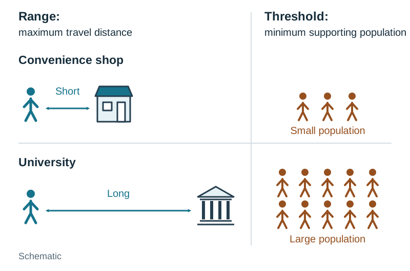
- Threshold: The minimum population needed to provide enough regular demand for a service or business to remain profitable.
- Range: The maximum distance a consumer is willing to travel to buy a particular good or service.
Hexagonal Hinterlands
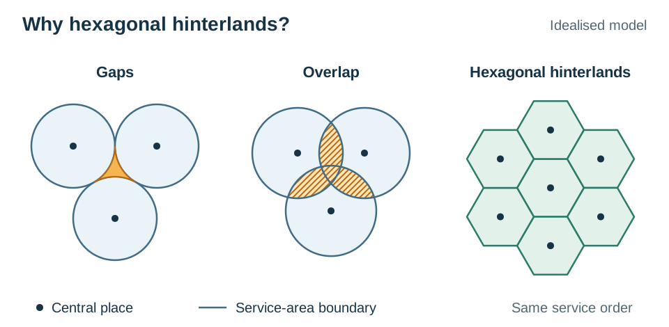
Christaller explained that hinterlands arrange into interlocking hexagons. If service areas were drawn as circles, they would either overlap (causing wasteful competition) or leave unserved triangular gaps between them. Hexagons fit together perfectly like a honeycomb, ensuring every consumer is served.
Diagram in words: To draw Christaller's model, place a large central city as a bold dot in the centre of a large hexagon (its high-order hinterland). At the six corners of this hexagon, place six smaller towns, each centered in its own medium-sized hexagon. At the corners of the town hexagons, place smaller villages, each surrounded by the smallest hexagons. Label the tiers: city, town, village, and note low-order and high-order hinterlands.
Hierarchy of Goods and Services
- Low-Order: Inexpensive everyday items bought frequently (milk, bread, newspapers, primary schooling). They have a low threshold and a short range, meaning people will not travel far. They locate in small villages and hamlets.
- Middle-Order: Moderately priced goods bought occasionally (supermarket shopping, clothes, secondary schooling, banking). They require a medium threshold and have a moderate range, locating in market towns.
- High-Order: Specialised, expensive items bought rarely (university education, specialist hospital treatment, designer jewellery). They require a very large threshold population and command a long range, locating only in large cities.
The Irish Urban Hierarchy
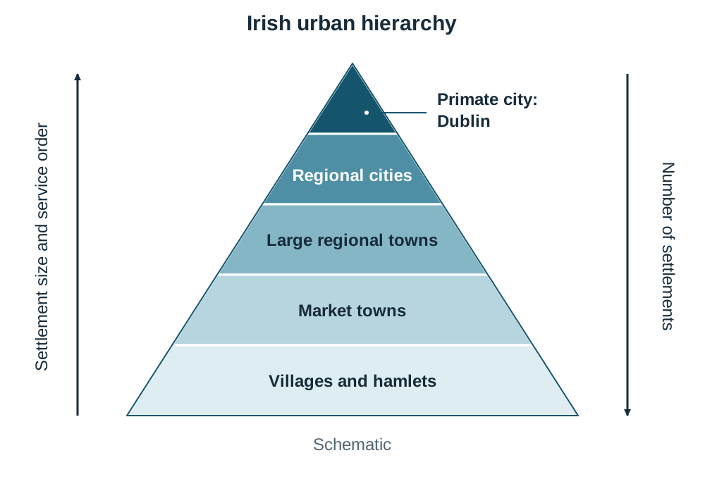
Settlements form a pyramid-shaped urban hierarchy. In an exam, draw this as a pyramid with Dublin at the apex and many small villages at the broad base:
- Primate City: Dublin (population c. 1.26 million in city and suburbs, Census 2022). It has more than five times the population of the next city, dominating government, corporate headquarters, and specialised tertiary hospitals.
- Regional Cities: Cork (c. 222,000), Limerick (c. 102,000), Galway (c. 83,000), and Waterford (c. 60,000). They provide universities, regional trauma hospitals, and large shopping centres.
- Large Regional Towns: e.g. Ennis, Sligo, Athlone, Letterkenny. They provide county council offices, general hospitals, and large secondary schools.
- Market Towns (Middle-Order): e.g. Carrick-on-Suir (population c. 5,700). It provides supermarkets, pharmacies, secondary schools, and a Garda station, but lacks a general hospital.
- Villages and Hamlets: e.g. Cloughjordan, Roundwood. They provide low-order services only: a primary school, post office, convenience shop, or pub.
Limitations of Christaller's Model in Ireland
- Physical Relief and Coastlines: Ireland is not an isotropic plain. Mountain ranges, bogs, and coastlines distort hinterlands. Coastlines cut hinterlands short: Galway Bay truncates Galway's hinterland to the south, and the Atlantic limits Sligo's to the west, so their service areas are not full hexagons.
- Modern Transport and Motorways: Motorways (such as the M7, M8, M6) let consumers bypass local market towns to travel quickly to large edge-of-city retail centres with free parking.
- Online Retailing: E-commerce lets rural households buy high-order goods online and have them delivered, breaking the link between physical central places and specialised shopping.
Key terms
- Site
- The exact physical ground upon which a settlement is built, including its altitude, relief, aspect, water supply, and drainage.
- Situation
- The position of a settlement relative to surrounding physical features, transport networks, and neighbouring population centres.
- Bridging Point
- A point where a river is shallow or narrow enough to be crossed by a ford or bridge, naturally focusing transport routes.
- Dry Point Site
- An elevated patch of well-drained ground on a floodplain or marsh that remains above flood level while keeping access to water.
- Fulachtaí Fia
- Bronze Age cooking sites: horseshoe-shaped mounds of burnt, shattered stone beside a water trough. On OS maps they are marked by name as an antiquity, usually near water.
- Crannóg
- An artificial island dwelling built of timber, stone, and brushwood in shallow lakes during Celtic and Early Christian times for defence.
- Dispersed Settlement
- A rural pattern of isolated, standalone farmsteads and dwellings scattered across farmland rather than grouped together.
- Nucleated Settlement
- A clustered pattern where houses and community buildings are grouped closely around a focal point such as a crossroads, green, or church.
- Ribbon Development
- A continuous row of single-house dwellings built along a roadway leading outward from a settlement.
- Counter-Urbanisation
- The movement of people and families from urban areas into surrounding rural districts and villages.
- Genuine Local Housing Need
- A planning criterion requiring applicants in rural pressure areas to prove farming employment or long-standing family ties to obtain planning permission.
- Central Place
- An urban settlement that provides goods, services, and administrative functions to the surrounding rural population.
- Hinterland
- The surrounding trade catchment area or sphere of influence served by a central place.
- Threshold
- The minimum population needed to provide sufficient demand for a business, service, or institution to remain economically viable.
- Range
- The maximum distance a consumer is willing to travel to purchase a specific good or use a service.
- Urban Hierarchy
- The ranking of settlements in an area into tiers based on their population size, order of services, and functional complexity.
- Primate City
- A leading city that has more than twice the population of the second-largest city in the state, dominating national economic and political life.
- Multifunctional Settlement
- A town or city that performs several economic, social, administrative, and cultural roles at the same time.
Check yourself
What is the difference between the range and the threshold of a service?
Range is the maximum distance consumers are willing to travel to obtain a good or service, whereas threshold is the minimum population needed to keep that service profitable.
Why did Walter Christaller use hexagons rather than circles to represent service hinterlands?
Hexagons tessellate across a landscape without leaving unserved gaps or creating overlapping zones of competition, which circular boundaries produce.
What historical process created Ireland's modern dispersed rural settlement pattern?
The breakup of communal rundale clusters after the Famine, followed by the Land Acts and Land Commission dividing land into private, compact farms where owners built individual farmhouses.
List three specific planning conditions commonly attached to permission for a rural one-off house.
A passed soil percolation test for the septic tank, clear sightlines at the driveway entrance onto the road, and an occupancy condition requiring the applicant to live in the home for a set number of years.
An aerial photograph shows a cathedral, a shopping centre with a large car park, and a deep-water quay with cranes. Name the three functions shown and give the visual clue for each.
Religious (ecclesiastical) function shown by the cathedral; commercial function shown by the shopping centre and car park; port/transport function shown by the deep-water quay with cranes.
What is a primate city, and what Census 2022 figure illustrates Dublin's status as one?
A primate city has more than twice the population of the country's second-largest city and dominates its economy and government. In 2022, Dublin (c. 1.26 million) had over five times the population of Cork (c. 222,000).