

Planning, sustainability, and environmental design govern where, what, and how we build. In Leaving Certificate Construction Studies, this topic links statutory planning legislation and local development plans with building physics, environmental science, rural and urban settlement design, vernacular conservation, and technical compliance under the Building Regulations, above all Part L (conservation of fuel and energy and nZEB), together with Part C (moisture and radon), Part F (ventilation), Part H (drainage and wastewater), and Part M (access and use). Higher Level questions almost always ask you to 'discuss in detail', which means you must state a point, explain the cause and effect behind it, and back it up with a figure, a named example, or a labelled sketch. The examination typically balances written discussions, numerical calculations of U-values and running costs, and freehand detail drawings.
Statutory Planning Hierarchy, Development Plans, and Urban Infill
Building development in Ireland is strictly controlled to protect public health and safety, prevent environmental degradation, safeguard architectural heritage, and ensure efficient capital expenditure on public infrastructure such as water, sewerage, transport, and schools.
Planning operates through a defined statutory hierarchy that moves from national policy down to individual building plots:
- National Planning Framework (NPF): Formulated under Project Ireland 2040, the NPF is the State's strategic spatial framework. Its central objective is compact growth — delivering at least 40% of all new homes nationally within the existing built-up footprints of settlements (50% within Dublin's built-up footprint and 30% in other settlements), instead of unmanaged greenfield sprawl.
- National Development Plan (NDP): The companion 10-year capital investment plan. It provides the funding mechanisms for roads, schools, water treatment, public transit, and hospital infrastructure needed to realise NPF goals. It is critical to distinguish the NPF (a spatial land-use policy) from the NDP (a financial infrastructure spending programme).
- Regional Spatial and Economic Strategies (RSES): Drawn up by Ireland's three Regional Assemblies (Northern & Western, Eastern & Midland, Southern) to coordinate environmental protection, transport corridors, and economic hubs across county boundaries.
- County and City Development Plans: Statutory blueprints adopted every six years by elected members of local authorities. These plans define local design standards, landscape protection policies, density targets, and legally binding land zoning maps.
- Local Area Plans (LAPs): Fine-grained frameworks prepared for specific towns, villages, or growth corridors, providing detailed layout rules and urban design requirements.
Strategic Development Zones: Adamstown Case Study
Adamstown, Co. Dublin, designated in 2001 as a Strategic Development Zone (SDZ) with its statutory Planning Scheme adopted in 2003, serves as the standard Leaving Certificate case study for sustainable planning. The SDZ mechanism approved a binding master plan in advance, speeding up planning approvals while legally mandating infrastructure before housing delivery. Adamstown applies three key sustainable principles: compact high-density housing (apartments, duplexes, and terraced houses), transit-oriented development anchored by Adamstown railway station and high-frequency bus corridors, and mixed-use community clustering with schools, healthcare, and retail built alongside homes.
A contrasting urban example is the regeneration of brownfield docklands and inner-city Architectural Conservation Areas (such as Smithfield or the Dublin Docklands), where former industrial land is remediated and reinhabited, preserving historic warehouse fabric while connecting straight into existing light rail and district services.
Developing Vacant and Brownfield Infill Sites
Developing urban infill sites offers several clear advantages:
- Infrastructure Reuse: Taps straight into existing roads, water mains, sewers, electricity networks, and broadband, eliminating the cost and carbon impact of greenfield utility extensions.
- Higher Density and Transit Viability: Concentrating residents supports local shops, pharmacies, and clinics, making frequent bus and light-rail routes economically viable.
- Active Travel: Places homes within walking and cycling distance of workplaces and schools, cutting fossil fuel emissions and traffic congestion.
- Urban Regeneration: Reclaims derelict sites, removing visual eyesores and reducing antisocial behaviour in town centres.
Street design in compact developments must safeguard residential amenity. Curtilage is the immediate enclosed land, garden, and outbuildings serving a dwelling. Planning standards recommend a minimum separation distance of 22 m between directly facing first-floor rear windows to protect family privacy. Ground-floor street façades should feature active frontages (frequent doors, display windows, and varied detailing) to maintain natural surveillance ('eyes on the street'). Layouts use chicanes, tight corner radii, textured or shared-surface paving, and raised tables so that traffic moves at walking or near-walking pace; DMURS sets a design speed of 30 km/h for local residential streets, with lower speeds in shared-surface home zones.
Planning Applications, Exempted Development, and Building Regulations
Under the Planning and Development Acts, any party carrying out development or making a material change of use must secure legal approval from the local planning authority.
The Four Classes of Planning Permission
- Full Planning Permission: The standard approval based on complete architectural and engineering drawings. Work may begin once a final grant is issued and a statutory Commencement Notice is registered. It is valid for five years.
- Outline Planning Permission: Tests whether a site is suitable in principle for a dwelling (evaluating access, visual impact, and wastewater suitability) before paying for full working drawings. It does not authorise construction. Full details must follow within three years via an application for Permission Consequent on Outline Permission.
- Permission Consequent on Outline Permission: Detailed working drawings submitted within the three-year statutory window of an outline grant, satisfying all conditions attached to the outline approval.
- Retention Planning Permission: A retrospective application lodged for work that was completed without permission or built in breach of approved drawings. The statutory fee is three times that of a standard application. If retention is refused, the development remains unauthorised and the planning authority may serve a warning letter and then an enforcement notice requiring the work to be altered or removed, with court proceedings and fines possible. Unauthorised work also makes the property very difficult to sell or mortgage.
Statutory Application Timeline and Public Notices
- Public Notice Window: Within a strict maximum of two weeks (14 days) prior to lodging documents, the applicant must publish a notice in an approved local newspaper and erect a weatherproof site notice at the site entrance, visible and legible from the public road.
- Public Observation Period: The site notice must be maintained in position for at least five weeks from the date the authority receives the application. The public has these five weeks to inspect documents and lodge written observations or objections (accompanied by the statutory €20 fee).
- Local Authority Decision: The authority cannot make its decision until the five-week submission period has expired, and must decide within eight weeks of receiving the application unless it issues a formal Request for Further Information (RFI), which stops the statutory clock.
- Appeals Window: Any aggrieved applicant or valid third-party objector has four weeks from the notification date to appeal the decision to An Coimisiún Pleanála (formerly An Bord Pleanála), whose rulings are legally final except on points of law.
Exempted Development and Planning Conditions
A grant of permission is rarely unconditional. Common conditions include specifying external finishes and colours, retaining existing hedgerows, creating splayed vehicular sightlines before occupation, disposing of surface water on site, constructing on-site wastewater systems to the EPA Code of Practice, paying financial development contributions, or imposing local occupancy restrictions.
Common reasons for refusal include contravening the zoning or rural housing policy of the Development Plan, creating a traffic hazard due to poor sightlines, premature development lacking water or road infrastructure, unsuitable subsoil for wastewater treatment, breaking the skyline on a scenic ridge, or constituting ribbon development.
Certain minor domestic developments are classed as exempted development and do not require planning permission. For a domestic rear extension, all of the following conditions must be met simultaneously:
- The extension must be positioned strictly to the rear of the original house.
- The floor area must not exceed 40 m² (this covers the cumulative total of all extensions built since the house was first occupied).
- An extension above ground floor level is restricted to a smaller floor area (12 m² for terraced/semi-detached, 20 m² for detached) within that overall 40 m² limit.
- Any window in an extension above ground floor level must be at least 11 m from the boundary it faces.
- At least 25 m² of private, unencumbered rear amenity open space must remain.
- Height limits apply: the roof must not exceed existing eaves heights or statutory flat-roof and pitched-roof height limits.
- Exempted works must still comply fully with the Building Regulations. Exemptions do not apply to a protected structure or within designated Architectural Conservation Areas.
If you are uncertain whether proposed work is exempt, you can apply to the planning authority for a Section 5 Declaration, a formal written decision confirming whether the work constitutes exempted development.
Contrasting Planning Controls with Building Regulations
Planning permission and the Building Regulations are separate legal frameworks:
| Feature | Planning Permission | Building Regulations (TGD Parts A–M) |
|---|---|---|
| Primary Focus | Land use, siting, external aesthetics, density, traffic safety, and amenity impact. | Technical construction performance, structural integrity, fire safety, and energy efficiency. |
| Legal Basis | Planning and Development Acts. | Building Control Acts. |
| Process & Approval | Public process with third-party observations and right of appeal to An Coimisiún Pleanála. | Mandatory technical standard; compliance is self-certified by the owner/builder/certifier. |
| Registration | Administered through local authority planning offices. | Formal Commencement Notice and Certificate of Compliance on Completion registered via the BCMS. |
Site Selection, Investigation, Siting, and Microclimate
Choosing the right site determines construction complexity, capital expenditure, running costs, and environmental impact. When answering exam questions on site selection, evaluate the site across three distinct levels: locality, plot of land, and exact building footprint.
Site Selection Checklist and Investigation Processes
Before purchasing or designing, investigate the following named factors:
- Services availability: Proximity to mains water, public sewer, electricity grid, and broadband; extending services across long distances is costly.
- Access and sightlines: Safe sight distance onto the public road in both directions, free of bends or crests.
- Orientation and aspect: Ability to face the main glazed living areas within 15° of due south to exploit free passive solar heat.
- Shelter and exposure: Existing land contours and mature trees that shield against severe winds.
- Subsoil and bearing capacity: Stable rock, firm gravel, or stiff clay allows simple strip foundations; peat or made ground requires expensive raft or piled foundations.
- Water table and flood risk: Check OPW flood maps; avoid land with rushes or high water tables that prevent on-site percolation.
- Radon potential: Check EPA radon maps; high radon areas require a fully sealed radon barrier and standby sump under Part C.
- Planning status: Zoning in the County Development Plan, local housing need criteria, Tree Preservation Orders, and landscape sensitivity designations.
Formal site investigation involves carrying out a topographical level survey, excavating trial pits to record soil strata and water table depth, conducting a percolation test for foul effluent, and identifying existing hedgerows and wayleaves.
Passive Solar Siting and Thermal Mass
To maximise passive solar gain, orient the building with its longest axis running roughly east-west, placing the primary living rooms (living room, kitchen, study) with large glazed windows facing within 15° of due south. Northern elevations should house unheated or secondary buffer rooms (utility, larder, bathrooms, hallway, garage) with minimal glazing to reduce fabric heat loss.
Solar geometry changes dramatically through the seasons in Ireland:
- Mid-winter (late December): The midday sun altitude is approximately 15°. Sun penetrates deep into the room, warming internal surfaces.
- Mid-summer (late June): The midday sun altitude climbs to approximately 58°. Overheating occurs unless structural shading is provided.
A calculated structural roof overhang or external brise-soleil blocks the high 58° summer sun while allowing the low 15° winter sun to pass underneath and heat the house for free.
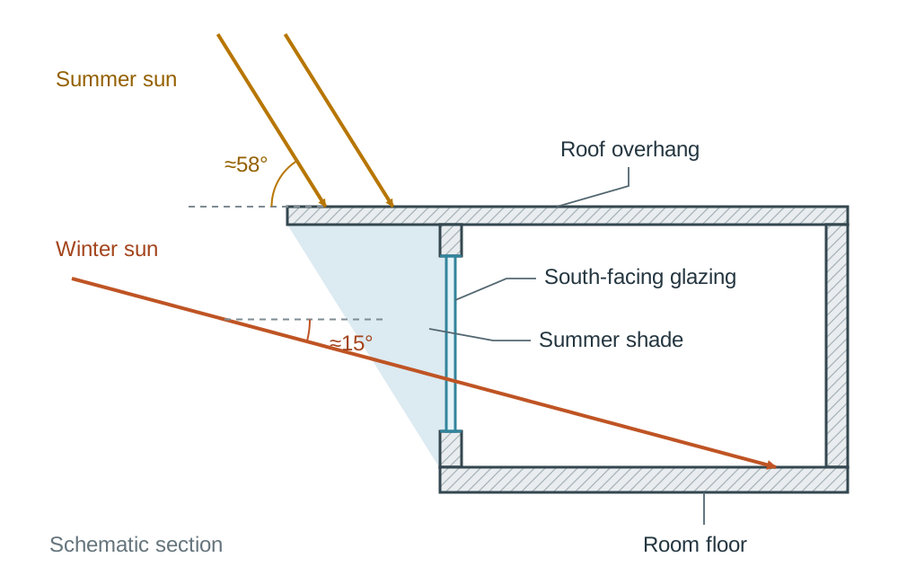
Thermal mass describes the ability of dense materials (such as an exposed concrete floor slab or heavyweight blockwork walls) to absorb surplus solar heat slowly during the day, preventing daytime overheating. In the evening, as the indoor temperature drops, this stored heat is radiated back into the living space. Lightweight timber-frame and plasterboard constructions lack thermal mass, meaning they warm up quickly but cool down just as rapidly once the sun sets.
Microclimatic Wind Protection
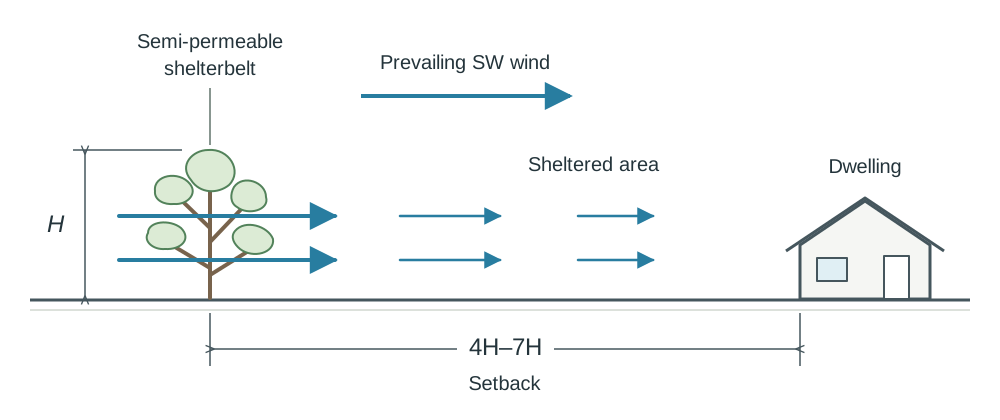
The prevailing wind in Ireland is from the south-west and west, driving rain against the external envelope and accelerating fabric heat loss through surface convection and air infiltration. An unsheltered site can consume 30% to 50% more space-heating fuel than a sheltered site.
- Shelterbelt Positioning: Plant the primary shelterbelt on the west and south-west boundaries. Siting the dwelling downwind within a distance of 4 to 7 times the mature tree height (H) creates an optimum microclimate free from damaging wind turbulence:
- Species Selection: The shelterbelt must be semi-permeable (roughly 50% porosity) using native species; a solid wall or dense barrier produces violent downwind turbulence. Plant an evergreen shelterbelt on the north and north-east boundaries to block freezing winter winds. Keep the south aspect open to the sun, planting only deciduous trees on the south: their summer leaves provide solar shading, while their bare winter branches let the low winter sun through.
Annotated Site Layout Sketch Requirements
In the exam, freehand site layout sketches must show clear labels for:
- North arrow and a distinct arrow showing the prevailing south-westerly wind.
- House footprint aligned with the long axis east-west and main glazing facing south.
- Semi-permeable shelterbelt on the west/south-west set back 4H to 7H from the dwelling.
- Deciduous planting to the south for seasonal solar control.
- Splayed road entrance with dashed sightline triangles along the public road.
- Percolation area positioned downslope, noting safe separation distances from the house and any well.
- Rainwater harvesting tank, permeable gravel driveway, and surface water soakaway.
- Topsoil stockpile and construction material storage areas.
Rural Settlement Patterns and Vernacular Conservation
Planning authorities seek to sustain rural communities while protecting the open countryside, agricultural land, and groundwater from uncontrolled, scattered development.
Rural Settlement Patterns
- Nodal Settlement: Dwellings clustered around an established social core (a crossroads, village church, school, or community hall). Planning policy strongly encourages nodal growth because it consolidates services (mains water, sewage treatment, school transport, broadband) and protects open agricultural fields.
- Linear (Ribbon) Development: Dwellings built in a continuous roadside string. Planning guidelines define ribbon development as 5 or more houses on one side of a public road over a 250-metre stretch. Ribbon development is heavily discouraged because it:
- Creates numerous vehicular access points onto fast rural roads, causing severe traffic hazards.
- Landlocks fertile agricultural land behind roadside plots.
- Erases scenic rural views and replaces them with an incongruous suburban streetscape.
- Destroys native roadside hedgerows and wildlife corridors.
- Makes the future provision of public water mains and sewers inefficient and expensive.
- Dispersed Settlement: Individual farmsteads and cottages scattered across open farmland, reflecting historic family agricultural land holdings.
Vernacular Architecture and Rural Integration
New rural houses should integrate sensitively into the landscape by following traditional Irish proportions:
- Form and scale: A simple rectangular plan one room deep, a narrow span of about 5 m to 7 m, a steeply pitched roof of roughly 40° to 45°, chimneys positioned on the gables, and small window openings with a vertical proportion set deep in the wall reveals.
- Topography: Nestled into natural contours rather than sitting exposed on a ridge or breaking the skyline.
- Restrained palette: Local rubble stone, smooth sand-cement or lime render, and natural blue-black slate. Avoid suburban classical features such as heavy double-fronted dormers, decorative columns, ornate brickwork, and large picture windows.
- Boundaries: Retain at least two existing natural boundaries (native hedgerows, dry-stone walls). Entrances should be splayed and discreet, using gravel or crushed stone rather than extensive tarmacadam and ornate automated gates.
Embodied Energy versus Operational Energy in Conservation
- Embodied Energy: The total cumulative energy consumed in extracting raw materials, processing, manufacturing, transporting, and assembling building materials on site. Demolishing an existing vernacular stone cottage throws away this embodied carbon and sends tonnes of masonry rubble to landfill. Conserving and repairing the structure retains that embodied energy and avoids manufacturing new carbon-intensive concrete, bricks, and steel.
- Operational Energy: The energy consumed during the day-to-day running of the home (space heating, hot water, ventilation, lighting, and appliances).
When renovating historic buildings, respect traditional building physics. Traditional solid stone and brick walls are breathable: they absorb moisture from rain and indoor humidity and evaporate it naturally to the outside. Sealing an old solid wall with impermeable Portland cement render or closed-cell plastic insulation traps moisture inside the masonry, because the wall can no longer dry outwards. The result is persistent damp, frost damage (spalling) to the stone, mould on internal finishes, and rot in embedded timbers such as joist ends and wall plates. Traditional structures must be repaired using breathable lime-based mortars, lime renders, and vapour-permeable insulation materials (such as cork or wood fibre).
Statutory protections include the Record of Protected Structures (RPS), which protects all parts of listed buildings (interiors, structural timbers, curtilage walls), Architectural Conservation Areas (ACAs) which safeguard streetscape character, and Tree Preservation Orders (TPOs) which protect significant trees and woodlands.
Thermal Performance: U-Values, Heat Loss, and Building Physics
Thermal performance calculations form one of the most reliable scoring areas on the Higher Level examination paper. Understanding the underlying building physics ensures accurate substitution and correct units.
Conductivity, Resistance, and U-Values
- Thermal Conductivity (): The rate at which heat passes through a material, measured in watts per metre per kelvin (). A low -value indicates a good thermal insulator (e.g. PIR insulation ; dense concrete block ).
- Thermal Resistance (): The ability of a specific layer of thickness (metres) to resist the flow of heat, measured in :
- Thermal Transmittance (-value): The rate of heat loss through one square metre of a complete composite building element for every 1 kelvin (or 1 °C) temperature difference between inside and outside, measured in . A lower -value means better insulation and lower heat loss:
where is the internal surface resistance, is the external surface resistance, and is the resistance of an unventilated cavity air space (values provided in examination tables).
Elemental maximum ('backstop') -values set out in Technical Guidance Document Part L for new dwellings mandate high performance: typically for external walls and ground floors, and lower again () for roofs. Always quote the specific values provided in your exam question tables.
Steady-State Heat Loss and Annual Running Cost
Total heat loss from a room or building envelope consists of fabric transmission loss plus ventilation loss:
- Fabric Heat Loss (): Heat escaping through walls, windows, floors, and roofs, measured in watts (W):
where is the element's -value (), is the element area (), and is the temperature difference between inside and outside ( or ).
- Ventilation Heat Loss (): Heat needed to warm incoming fresh outdoor air to room temperature, measured in watts (W):
where is the volumetric heat capacity of air (), is the ventilation rate in air changes per hour (), and is the internal room volume ().
- Annual Running Cost and Costs-in-Use:
To calculate space-heating running costs:
Costs-in-use calculations compare the whole lifetime ownership cost of building systems over an agreed period (e.g. 15 to 20 years): capital purchase cost + installation cost + annual fuel running costs + maintenance and replacement costs. For example, an air-to-water heat pump carries a higher initial capital cost than an oil boiler, but with a Seasonal Coefficient of Performance (COP) of 3.5 it produces 3.5 kWh of heat for every 1 kWh of electricity consumed. Over a 15-year period, the heat pump's lower running costs and available grant aid make it significantly cheaper in overall costs-in-use.
Sustainable Construction: Airtightness, Ventilation, Condensation, and Energy Standards
Modern building physics requires a coordinated approach to thermal insulation, air barriers, controlled ventilation, and moisture management.
Thermal Bridging
A thermal bridge (cold bridge) is a localised zone within the building envelope where heat escapes much faster than through the surrounding construction because insulation is broken, compressed, or omitted. Typical locations include window and door jambs, sills, and heads; floor-to-wall junctions; eaves junctions; and uninsulated concrete lintels.
Consequences of thermal bridging include accelerated heat loss, localised cold internal surfaces, and severe surface condensation leading to black mould growth and dust staining. Remedies include maintaining an unbroken line of insulation, using insulated cavity closers at window reveals, returning insulation around lintels, using lightweight aerated concrete blocks at wall-floor junctions, and adhering to the government's Acceptable Construction Details.
Airtightness, nZEB, and BER
Airtightness is the elimination of uncontrolled air leakage (draughts) through cracks and gaps in the external envelope. It is measured on site using a blower-door (fan pressurisation) test and expressed as air permeability in of envelope area at a pressure difference of 50 Pa. Technical Guidance Document Part L sets strict maximum permitted air permeability limits for new dwellings. Airtightness is achieved by installing a continuous airtightness membrane or wet-plaster skim, taping all joints with proprietary airtight tapes, and sealing every pipe, wire, and duct penetration.
Advantages of an airtight dwelling include:
- Reduced heat loss: Eliminating draughts through the fabric cuts heat escaping, reducing boiler run time and heating bills.
- Enhanced occupant comfort: Prevents cold draughts, chills, and uneven room temperatures.
- Optimised insulation performance: Air movement through mineral wool or cellulose insulation destroys its thermal resistance; an airtight seal protects insulation integrity.
- Fabric protection: Prevents warm, humid indoor air from entering wall cavities and timber roofs, eliminating interstitial rot.
- Acoustic insulation: A well-sealed envelope reduces external noise ingress.
The golden rule of sustainable construction is 'build tight, ventilate right'. An airtight house must be equipped with controlled ventilation, typically Mechanical Ventilation with Heat Recovery (MVHR). An MVHR unit extracts warm, moist, stale air from 'wet' rooms (kitchens, bathrooms, utility) and passes it through an air-to-air heat exchanger. Incoming cold, fresh, filtered air from outside absorbs up to 90% of the heat from the exhaust air without the two air streams ever mixing, delivering clean, pre-warmed fresh air to bedrooms and living spaces.
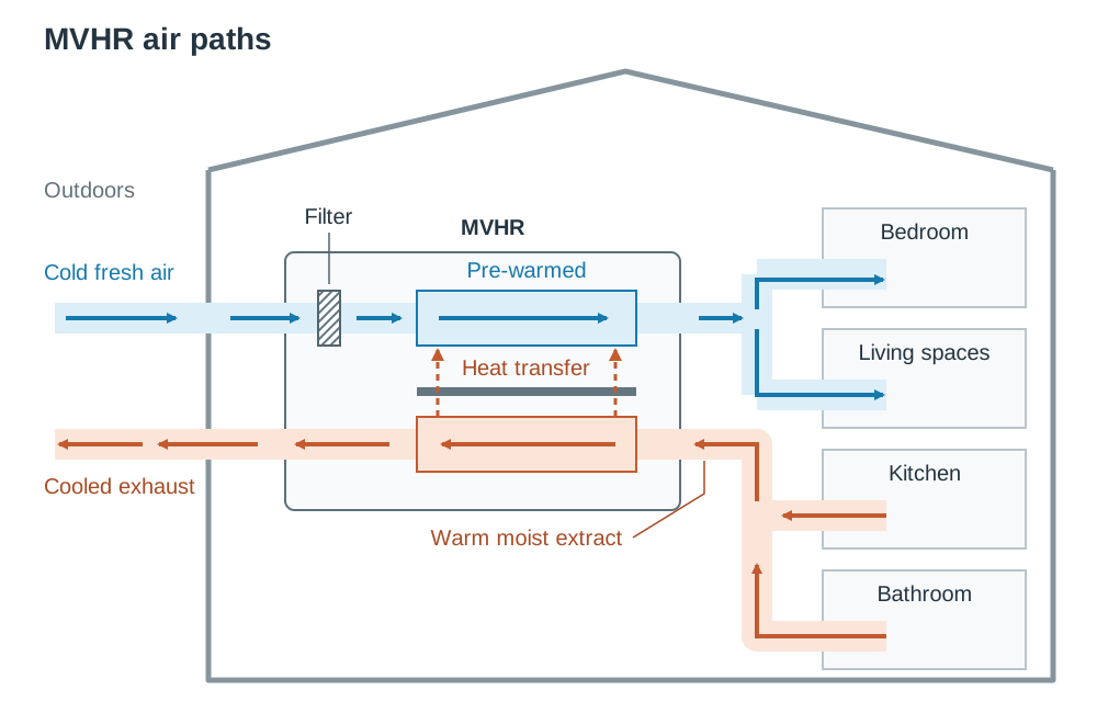
All new dwellings must meet the Nearly Zero Energy Building (nZEB) standard under Part L: an extremely high energy performance where the very low amount of energy required is covered to a very significant extent by energy from renewable sources produced on-site or nearby. Compliance is certified via a Building Energy Rating (BER), which grades dwellings from A1 down to G. New nZEB homes typically achieve an A2 or A1 rating.
Condensation and Vapour Barriers
Warm air can hold significantly more water vapour than cold air. The dew point is the temperature at which air becomes saturated with moisture and water vapour condenses into liquid water.
- Surface Condensation: Occurs when warm, humid room air hits an internal surface whose temperature is below the dew point (such as single glazing, cold window reveals, or thermal bridges). It is prevented by increasing insulation, eliminating cold bridges, and exhausting moist air at source using mechanical extract fans.
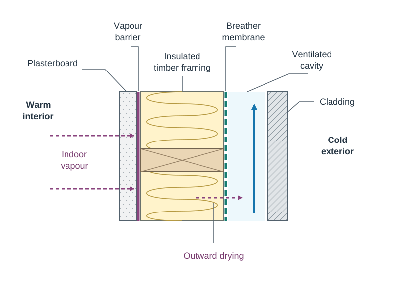
- Interstitial Condensation: Occurs hidden inside the structural elements, where moisture vapour diffuses through plasterboard into the cold outer layers of a wall or roof and condenses into liquid water, wetting insulation and rotting timber rafters or studwork.
To prevent interstitial condensation, install a continuous vapour barrier (vapour check) on the warm side of the insulation (directly behind the internal plasterboard finish), with all joints fully taped. This stops indoor water vapour from entering the construction. Conversely, the outer cold side of the envelope must be allowed to breathe: install a vapour-permeable breather membrane on the external face of timber framing, maintain a ventilated clear cavity behind external cladding, and provide cross-ventilation in cold roof spaces.
Water Conservation, Sustainable Drainage (SuDS), and Wastewater Treatment
Sustainable domestic construction requires responsible water management: conserving treated mains water, attenuating surface storm runoff, and treating foul wastewater safely on site.
Rainwater Harvesting and Greywater Reuse
A rainwater harvesting system collects clean runoff from pitched roofs via gutters and downpipes, filters out leaves and debris, and stores the water in an underground or above-ground storage tank. A header tank or submersed pump redistributes the harvested water through a dedicated, independent pipe network for non-potable uses: WC toilet flushing, washing machines, car washing, and garden irrigation.
- Benefits: Reduces household mains water demand and charges by up to 50%, reduces stormwater volumes entering public storm drains, and because rainwater is naturally soft, reduces limescale build-up in washing machines.
- Design rules: Harvested non-potable pipework must be completely separate from drinking water supplies, clearly colour-coded and labelled, and fitted with certified backflow-prevention valves to eliminate any risk of cross-contamination.
Greywater recycling systems collect wastewater from showers, baths, and wash-hand basins, filter and disinfect it, and reuse it for toilet flushing. However, greywater systems carry higher maintenance and pump costs than rainwater harvesting.
Sustainable Drainage Systems (SuDS)
Traditional drainage routes surface water straight into underground pipes, discharging directly into rivers and overloading municipal storm sewers during intense storms, causing flash flooding and river pollution. SuDS (Sustainable Drainage Systems) manage rainfall at the source, mimicking natural hydrological drainage by filtering runoff, promoting on-site infiltration, and attenuating peak flow rates:
- Permeable paving: Driveways and patios built with porous blocks, gravel, or porous asphalt over an open-graded stone sub-base that allows rainwater to soak into the subsoil.
- Soakaways and infiltration trenches: Underground stone-filled pits that store storm runoff and let it infiltrate slowly into surrounding soil.
- Swales: Broad, shallow, grass-lined channels that convey and filter surface runoff, slowing water velocity and trapping suspended sediments.
- Green roofs: Planted sedum roofs that absorb rainwater, delay roof discharge, and enhance biodiversity.
- Attenuation tanks: Underground storage chambers fitted with flow-control valves (hydro-brakes) that hold peak storm water and release it at a controlled, steady greenfield rate.
On-Site Foul Wastewater Treatment
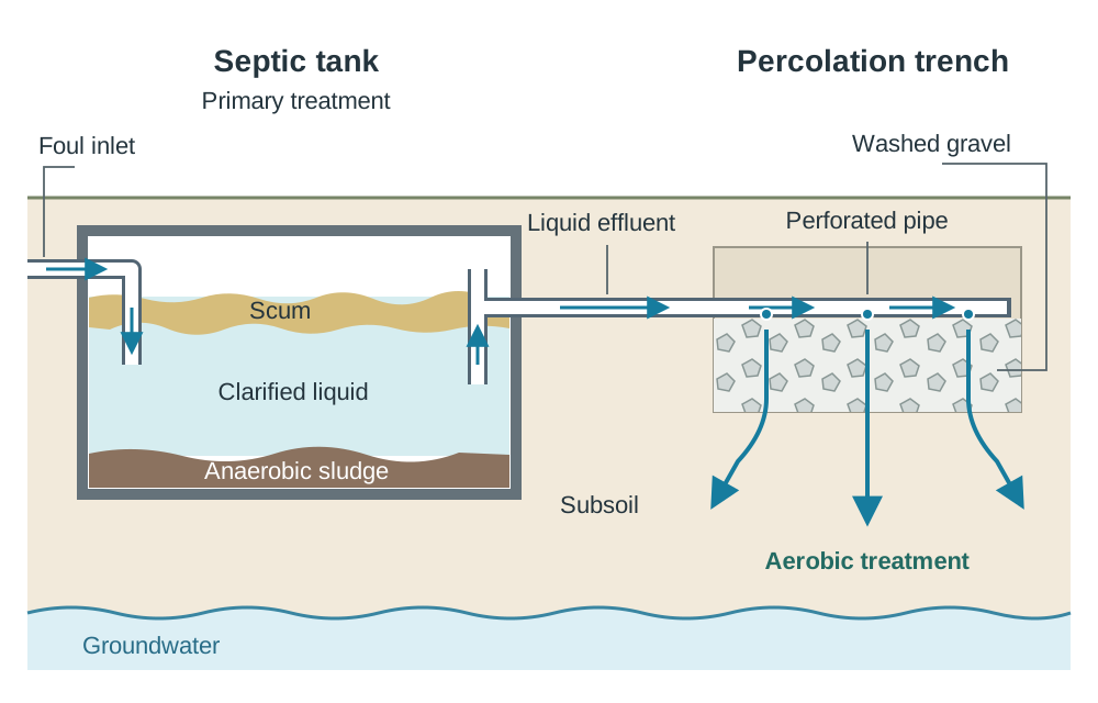
Where a public sewer is unavailable, foul effluent must be treated safely on site in accordance with the EPA Code of Practice. A separate drainage system must always be installed, keeping foul sewage entirely separate from surface rainwater.
- Septic Tank System: Provides only primary treatment. Heavy solids settle to the bottom to form anaerobic sludge, while light grease and oils float to the top as scum. The clarified liquid effluent discharges to an underground percolation area consisting of perforated pipes laid over washed gravel trenches. Aerobic bacteria in the subsoil provide final biological purification before effluent reaches the groundwater.
- Proprietary Wastewater Treatment System: Used on sites with restricted area, high water tables, or poor percolation. The unit incorporates secondary treatment (mechanical aeration or moving-bed biofilters) that actively digests organic contaminants, producing a much cleaner effluent. It requires an electrical supply, air blowers, and regular servicing.
The Percolation Test (T-Test) Procedure
Before receiving planning approval for an on-site wastewater system, an EPA-certified percolation test must be performed in exact sequence:
- Excavate trial pits to inspect subsoil strata and measure the depth to bedrock and the winter water table.
- Dig test holes of specified standard dimensions ( deep) at the proposed percolation trench depth.
- Pre-soak the test holes thoroughly with water over several hours so the soil is fully saturated.
- Refill the hole with water and record the time, in seconds, required for the water level to drop by 100 mm.
- Divide the recorded time by 100 to determine the T-value (the time in seconds for the water level to drop by 1 mm).
- Compare the T-value against the EPA Code of Practice limits. A T-value that is too fast () indicates gravelly soil where effluent passes straight into groundwater unpurified. A T-value that is too slow () indicates dense clay or peat where effluent ponding will occur on the ground surface. The T-value dictates whether a traditional septic tank is permissible or a mechanical treatment system and raised mound are legally required, as well as the exact length of percolation trenching.
The EPA Code of Practice also specifies mandatory minimum separation distances: typically at least 7 m from the percolation area to any dwelling house, 3 m from any site boundary, and between 15 m and 60 m (depending on soil slope and aquifer vulnerability) from any potable drinking water well.
Universal Design and Technical Guidance Document Part M
Technical Guidance Document Part M (Access and Use) ensures that new dwellings and public buildings are visitable and usable by everyone, regardless of age, size, or physical ability (Lifetime Use). Good design avoids creating obstacles for people with impaired mobility, vision, or hearing.
Accessible Approaches, Ramps, and Entrances
- Approach Gradients:
- Gradients up to 1:50 are classified as a level approach.
- Gradients between 1:50 and 1:20 are classified as a gently sloping approach.
- Gradients steeper than 1:20 are classified as ramps. The gradient should be as shallow as possible; 1:12 is the absolute maximum and is permitted only over short flights. Each ramp flight must have a level landing at the top, bottom, and at every change of direction. Ramps must provide a firm, slip-resistant surface and a minimum clear width of 900 mm.
- Main Entrance Door & Landing:
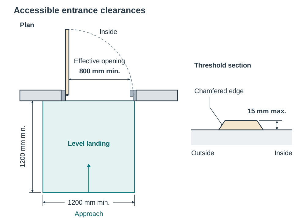
- A level exterior landing measuring at least 1200 mm × 1200 mm must be provided clear of the door swing.
- The raised door threshold must not exceed 15 mm in height, with chamfered or rounded edges to allow smooth wheelchair crossing.
- The entrance door must provide an effective clear opening width of at least 800 mm.
Internal Circulation and Doorways
- Corridors on the entrance level must have an unobstructed clear width of at least 900 mm (which may reduce to 800 mm at isolated pinch points such as radiators, provided they do not face a doorway).
- Internal doors to habitable rooms on the entrance level must provide an effective clear opening width of at least 800 mm.
- A clear opening of 775 mm is permissible only for doors leading to secondary non-habitable areas or upper storeys reached solely by stairs.
Room Clearances, Sanitary Facilities, and Control Heights
- Wheelchair Turning Circle: Accessible kitchens and accessible entrance-level bathrooms must provide an unobstructed wheelchair turning circle of at least 1500 mm in diameter.
- Accessible WC: Provide a clear transfer space of at least 750 mm × 1200 mm alongside the toilet bowl, with horizontal grab rails installed at the height specified in current TGD Part M (approximately 700 mm above finished floor level) and a wash-hand basin wall-mounted without a pedestal to provide leg clearance.
- Switches, Sockets, and Controls:
- Light switches, doorbells and intercoms must be positioned between 900 mm and 1200 mm above finished floor level. Door handles and other ironmongery may be positioned anywhere between 800 mm and 1200 mm, with 900 mm the recommended optimum height.
- General-purpose electrical sockets must be positioned between 400 mm and 1200 mm above finished floor level to prevent straining from a seated wheelchair position.
Key terms
- Compact Growth
- The national planning objective under Project Ireland 2040 that targets delivering at least 40% of all new homes nationally (50% in Dublin) within existing built-up urban footprints rather than through unmanaged greenfield sprawl.
- Strategic Development Zone (SDZ)
- A designated land area for which a comprehensive statutory planning scheme is adopted in advance to fast-track residential, commercial, and physical infrastructure delivery, as demonstrated at Adamstown.
- Exempted Development
- Specific categories of minor domestic building works (such as a ground-floor rear extension up to 40 m² leaving at least 25 m² of private rear garden) that do not require formal planning permission provided all statutory conditions are met.
- Retention Planning Permission
- A retrospective application to regularise unauthorised building work, carrying three times the standard statutory fee with the legal risk of enforcement action or alterations if refused.
- Section 5 Declaration
- A formal written legal determination issued by a local planning authority confirming whether a specific proposed development is or is not exempted from planning permission.
- Linear (Ribbon) Development
- A continuous roadside string of five or more houses on one side of a public road over a 250-metre stretch, strongly discouraged due to traffic hazards, agricultural landlocking, and service inefficiencies.
- Thermal Conductivity (k)
- The rate at which heat passes through a material, measured in watts per metre per kelvin (W/mK); lower values indicate superior insulating performance.
- Thermal Transmittance (U-value)
- The rate of heat loss through one square metre of a complete composite building element for every 1 kelvin (or 1 °C) temperature difference between inside and outside, measured in W/m²K.
- Thermal Bridge
- A localised section of the building envelope where insulation is interrupted or thinner, allowing rapid heat loss, cold surface temperatures, and condensation.
- Airtightness
- The elimination of uncontrolled air infiltration through gaps in the building fabric, measured via a blower-door test and expressed as air permeability at 50 Pa.
- nZEB (Nearly Zero Energy Building)
- The statutory energy performance standard under Part L requiring all new dwellings to have very high efficiency, with the remaining minimal energy demand covered largely by renewable sources.
- Embodied Energy
- The total cumulative energy consumed in the extraction, processing, manufacture, transport, and site assembly of building materials over their lifecycle.
- SuDS (Sustainable Drainage Systems)
- Water-management techniques (such as permeable paving, swales, soakaways, and green roofs) designed to drain surface storm runoff naturally, prevent flooding, and reduce sewer overload.
- Percolation Area
- A series of subsoil trenches filled with washed stone and perforated pipes that disperse clarified effluent from a septic tank or treatment unit, allowing natural aerobic purification in the soil.
Check yourself
A 200 mm hollow concrete block wall has a total thermal resistance of 0.50 m²K/W including surface resistances. What is its U-value, and what does this indicate about its thermal performance?
U = 1 ÷ 0.50 = 2.0 W/m²K. This indicates very poor thermal performance, as it loses heat at more than ten times the rate permitted for a new wall under current Part L standards (0.18 W/m²K).
On which side of the thermal insulation should a vapour check membrane be positioned, and why?
On the warm side of the insulation (directly behind the internal plasterboard) to prevent warm, moisture-laden indoor air from entering the structure and condensing inside cold layers (interstitial condensation).
What is the statutory definition of rural linear (ribbon) development?
Five or more houses built consecutively on one side of a public road over a 250-metre stretch.
What is the primary wind direction in Ireland, and where should the primary semi-permeable shelterbelt be sited relative to the dwelling?
The prevailing wind is from the south-west and west; the shelterbelt should be planted on the west and south-west boundaries at a distance of 4 to 7 times the mature height of the trees (4H to 7H) from the house.
What are the approximate midday solar altitude angles in Ireland at mid-winter and mid-summer?
Approximately 15° at mid-winter (late December) and 58° at mid-summer (late June).
What minimum clear opening width must an accessible entrance door achieve, and what is the maximum height for an accessible threshold under Part M?
A minimum effective clear opening width of 800 mm, and a maximum threshold upstand height of 15 mm with chamfered or rounded edges.
What is the difference between primary wastewater treatment in a septic tank and secondary treatment in a mechanical unit?
A septic tank provides only primary physical treatment (settlement of sludge and flotation of scum); a mechanical unit adds secondary biological treatment (active aeration or filtration), producing a cleaner effluent suitable for poorer soils.
What is the purpose of an EPA percolation T-test, and what do extreme T-values signify?
The T-test measures the time in seconds for water to drop 1 mm in saturated subsoil. A value below 3 means percolation is too rapid (polluting groundwater untreated); a value above 50 means percolation is too slow (causing surface ponding).