

For this topic, you need to master three core elements. First, pick a specific local ecosystem you can actually visit, such as an Irish river stretch, raised bog, saltmarsh, or hedgerow, and explain how it and human wellbeing depend on one another. Second, investigate how a single environmental factor affects air, water, soil, or biodiversity there, collecting your own primary field data to back up your findings. Third, outline concrete actions to protect or restore that ecosystem. This work links directly with nature-connection activities and local land-use debates. Keep in mind that your Strand 1 ecological fieldwork supports the final written examination; it is distinct from your individual 40% Action Project.
The Chosen Local Ecosystem and Two-Way Interdependence
An ecosystem consists of a biological community of interacting organisms (biotic factors) and their physical, non-living environment (abiotic factors such as water, light, temperature, and minerals) functioning together as a distinct unit.
Picking a Workable Local Ecosystem
To make your exam answers specific and grounded, select a site you can easily study in person:
- A local stream or riverbank: investigate nutrient runoff or bank erosion using kick sampling, dissolved oxygen meters, and water clarity tubes.
- A raised or blanket bog: investigate artificial drainage or scrub encroachment using peat moisture checks, water table depth measurements, and plant cover surveys.
- A school hedgerow or woodland border: investigate light levels or proximity to traffic using light meters, vegetation transects, or air quality diffusion tubes.
- An amenity grassland or park margin: investigate trampling pressure along desire lines using water infiltration cylinders and soil penetrometers.
Understanding Interdependence
Interdependence is a two-way street. Human wellbeing relies on ecosystem services, which are the direct and indirect benefits nature gives us. In return, the condition and resilience of that ecosystem depend on human management decisions. Describing only how people extract resources misses the mutual nature of this relationship.
You should be ready to explain how your chosen local ecosystem and human wellbeing connect across five core areas:
- Climate Protection:
- What it gives us: Intact habitats store carbon and absorb floods. Coastal saltmarshes trap organic carbon in waterlogged, anaerobic muds (known as blue carbon), while their vegetation dampens storm wave energy to protect shorelines. Peat bogs store ancient carbon and function like sponges, soaking up torrential rainfall and releasing it slowly to protect downstream communities from flash floods.
- What we do to it: Draining peatlands or clearing coastal saltmarshes releases stored carbon as greenhouse gases and strips away natural flood defences. In contrast, rewetting bogs and restoring saltmarshes reinstates that protection.
- Livelihoods:
- What it gives us: Clean rivers and coastal estuaries provide safe nursery grounds for fish and shellfish, supporting commercial fishing, angling tourism, and local hospitality businesses.
- What we do to it: Over-abstracting water, dredging river gravels, or discharging agricultural slurry destroys spawning redds and harms local employment. Careful catchment management keeps fish stocks viable and preserves local jobs.
- Health and Leisure:
- What it gives us: Walking, kayaking, or birdwatching in natural green and blue spaces lowers blood pressure and relieves stress, encouraging regular exercise. Vegetated wetlands also filter sediment, excess nutrients, and pathogens before surface water reaches drinking intakes.
- What we do to it: Discharging raw sewage or removing bankside trees spoils public recreation and threatens drinking supplies. Protecting green corridors and streams guards both clean drinking water and community amenities.
- Aesthetic and Cultural Value:
- What it gives us: Natural landscapes inspire community folklore, local art, and regional identity. In Ireland, many townland names reflect natural habitats, such as those containing móin (bog) or doire (oak wood).
- What we do to it: Illegal dumping, littering, and insensitive developments ruin landscape character. Community conservation days and heritage trails preserve both local ecology and cultural memory.
- Realisation of Human Rights:
- What it gives us: International frameworks recognise that access to a clean, healthy, and sustainable environment is a human right. Intact ecosystems underpin safe drinking water, dependable food supplies, and shelter from environmental hazards.
- What we do to it: Contaminating local rivers or soils directly deprives communities of their basic right to clean water and safe living conditions.
Planning Field Investigations: Safety, Ethics, and Primary Data
Your ecological investigation requires you to measure how one specific environmental factor affects a chosen habitat using primary data that you collect directly.
Keep the two main variables clear. The environmental factor is the external pressure you are testing, such as fertilizer runoff, car exhaust, or foot trampling. The measured response is the biological or physical change you record in response, such as a drop in mayfly nymphs, a decrease in dissolved oxygen, or slower soil infiltration.
Fieldwork Preparation, Safety, and Ethics
Before gathering any field data, put the essential safety and ethical checks in place:
- Permissions: Always get clear approval from school management and the landowner or local authority before stepping onto private property or protected reserves.
- Water safety: Never carry out water sampling on your own. Work in pairs under adult supervision, steer clear of deep or fast currents, wear well-gripped boots or waders, and wash your hands thoroughly to guard against infections like leptospirosis.
- Habitat care: Follow Leave No Trace principles. Minimise disturbance to bankside vegetation, put turned riverbed stones back where you found them, and return captured live animals quickly to the water.
- Privacy and data handling: Follow standard data protection rules by making sure any photographs of your study site do not show identifiable faces.
Survey Terms and Tools
- Quantitative data are numerical records paired with standard units, such as 14 stonefly nymphs per net sample, a dissolved oxygen level of 7.2 mg/L, or a soil infiltration time of 95 seconds.
- Qualitative data are non-numerical descriptive notes, such as dark anaerobic silt on a gravel bed, a strong odour of slurry near an outfall pipe, or bushy lichens growing on tree bark.
- A quadrat is a square frame of fixed area, commonly 0.5 m by 0.5 m, placed on the ground to count plants or estimate percentage cover systematically.
- A transect is a tape measure laid across an environmental gradient, such as moving outward from a compacted footpath into open grassland, along which you take samples at regular intervals.
- A control site is an unimpacted reference area that shares the same natural soil, slope, and light conditions as your impacted site. Without a control, you cannot prove whether your measured factor caused the ecological difference.
Field Protocols Across Environmental Media
Air, water, soil, and biodiversity are not separate ecosystems. They are the physical media and living characteristics that make up your chosen study area.
1. Water Quality and Freshwater Ecology
- Environmental Factor: Organic nutrient runoff from farm slurry or septic tank leaks.
- Abiotic Testing: Use calibrated field probes or colourimetric kits to record dissolved oxygen (in mg/L), pH, and temperature (in °C). Remember that heavy algal blooms can cause artificially high oxygen readings in the afternoon due to active photosynthesis, followed by severe oxygen drops at night.
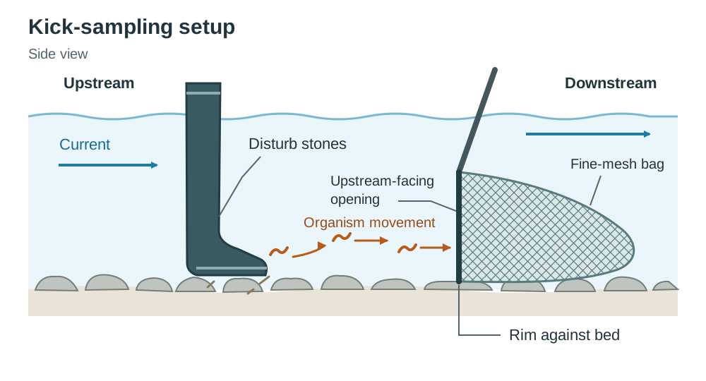
- Kick Sampling Protocol: Place a fine-mesh hand net upright on the stream bed facing upstream in a shallow riffle. Disturb the stones immediately upstream with your boot for exactly two minutes, then pick over larger cobbles by hand for one minute to catch clinging organisms. Empty the net into a white sorting tray and separate the macroinvertebrates. Pollution-sensitive species like flattened mayfly nymphs and stonefly nymphs need clean, oxygen-rich conditions. Pollution-tolerant species like bloodworms (Chironomid larvae) and tubificid sludge worms survive easily in murky, low-oxygen water.
2. Soil Compaction and Water Infiltration
- Environmental Factor: Trampling pressure along paths in public parks or school grounds.
- Field Protocol: Drive an open metal cylinder five centimetres into the ground. Pour in a set volume of water, such as 250 mL, and time how many seconds it takes to drain completely. A longer infiltration time indicates a lower infiltration rate, showing that foot traffic has compacted the soil pores.
3. Air Quality and Biological Indicators
- Environmental Factor: Vehicle emissions along a roadside woodland edge.
- Field Protocol: Mount nitrogen dioxide (NO₂) diffusion tubes at fixed distances along a transect moving away from the road. Pair those chemical numbers with a qualitative survey of lichens on mature tree bark. Bushy (fruticose) lichens point to clean air, while crusty (crustose) lichens survive in dirtier air.
4. Biodiversity and Plant Cover
- Environmental Factor: Canopy shade along a woodland margin or mowing frequency on school lawns.
- Field Protocol: Lay a transect line across the gradient and position a 0.5 m by 0.5 m gridded quadrat at set distances. Record species richness (the total count of different species) and determine the percentage cover of dominant ground plants.
Presenting Data and Essential Calculations
Clear presentation lets you see ecological trends clearly and draw defensible conclusions in written exam papers.
Presenting Field Evidence
- Data Tables: Organise measured variables or organisms in rows and sample sites across columns. Always put units in the column headings (such as 'Dissolved Oxygen (mg/L)'), not repeated beside every single number.
- Graph Selection: Use a bar chart when comparing discrete categories or distinct sample locations, such as upstream Site A versus downstream Site B. Use a line graph only when your horizontal axis represents a continuous scale, such as distance along a transect line or time.
- Describing Patterns: Quote exact numbers with units and state the direction of change. Write that 'mean stonefly numbers fell from 15.0 upstream to 1.0 downstream', rather than saying 'the line dropped'.
- Replication: Never rely on a single measurement. Taking at least three replicate samples at each location allows you to calculate a dependable mean and spot anomalous outliers.
Essential Calculations
1. Arithmetic Mean:
2. Percentage Frequency:
3. Percentage Cover:
4. Percentage Change:
A negative answer shows a percentage decrease; a positive answer shows a percentage increase.
Take care with units: If plant cover drops from 60% down to 30%, that is a drop of 30 percentage points, but a 50% decrease. State your calculation clearly in your exam answers.
Actions to Protect and Restore Local Ecosystems
Restoring an ecosystem means tackling the root causes of environmental damage rather than managing superficial symptoms. Picking floating cans out of a pond will not fix upstream nutrient pollution.
The Sequence of Eutrophication
Eutrophication happens when excessive nutrients, especially nitrates and phosphates, enter a waterway from farm slurry, artificial fertiliser, or unserviced septic systems. The damage unfolds in a clear sequence:
- Rain washes excess dissolved nutrients into streams and lakes.
- Algae feed on the nutrients and multiply rapidly, forming dense green blooms that block sunlight.
- The algae die once nutrients run low and sink to the bottom.
- Aerobic bacteria feed on the dead algal biomass and multiply rapidly, consuming dissolved oxygen.
- Water oxygen levels plummet, causing sensitive fish and macroinvertebrates to suffocate, while pollution-tolerant organisms take over.
Practical Restoration Measures
| Level of Action | Target Issue | Practical Evidence-Based Action | Ecological Mechanism |
|---|---|---|---|
| Individual / School | Riverbank erosion and animal trampling | Plant native whips (alder and willow) along the bank and install signs. | Tree roots knit the soil together, stabilising the bank and preventing silt from smothering gravel beds. |
| Community | Raised bog drying out from scrub invasion | Organise volunteer workdays to cut back invasive birch scrub and Rhododendron. | Stops excessive water loss from leaf transpiration, letting native Sphagnum mosses recover the damp surface. |
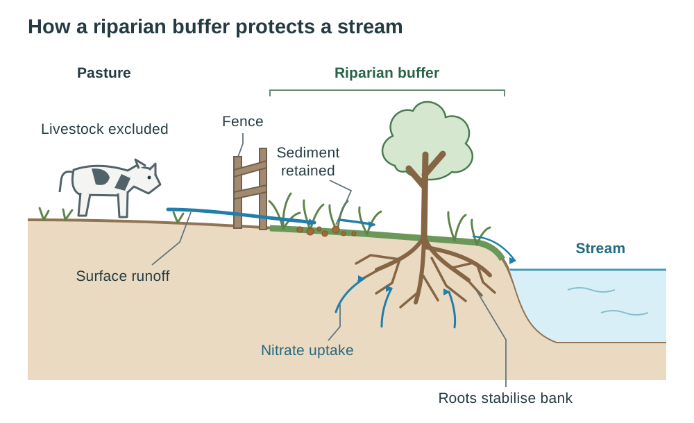
| Landowners / Farmers | Agricultural stream nutrient runoff | Put up livestock fencing along a riparian buffer strip (3 to 10 m wide) and use Low Emission Slurry Spreading (LESS). | Fencing keeps cattle out; buffer roots soak up dissolved nitrates before they reach water; LESS injects slurry onto the soil surface, cutting runoff and ammonia drift. |
| Local Authority / State | Drained peatland losing carbon and species | Block drainage ditches with timber dams and enforce Special Area of Conservation (SAC) status. | Raises water tables to re-establish anaerobic peat, halting carbon loss and legally halting destructive activity. |
At national and European levels, key habitats are protected as Special Areas of Conservation (SACs) under the EU Habitats Directive and Special Protection Areas (SPAs) for birds under the Birds Directive. Together, these form the Natura 2000 network. Nationally important sites are designated as Natural Heritage Areas (NHAs). If your chosen local ecosystem sits within a designated site, name that status in your exam answers.
Connecting with Nature and Land-Use Dilemmas
Spending time outdoors in natural spaces lowers stress hormones, sharpens attention, and helps people care about protecting local habitats. People protect the places they know and value.
Participatory Experiences
A participatory nature experience gets people actively investigating their surroundings rather than listening to a lecture. Participants might carry out simple kick samples in a river, test water clarity with tubes, or log plant diversity across a park transect. Using their own field data, they then discuss how local management choices shape habitat health.
Analysing Land-Use Dilemmas
When decisions are made about natural land, different stakeholders hold unequal amounts of power and conflicting priorities:
- A typical Irish dilemma: A commercial proposal to plant non-native Sitka spruce across cutover blanket bog in the west of Ireland.
- Landowners and forestry investors: Seek planting grants and future timber revenue. They hold private legal property rights and financial capital.
- State bodies (Department of Agriculture, NPWS): Regulate afforestation licences and manage conservation obligations. They hold statutory and legal authority.
- Local residents and community conservationists: Worry about biodiversity loss, soil carbon release from site preparation, and stream acidification. They rely on public submissions, local campaigns, and community meetings to voice their concerns.
- The ecosystem and future generations: Directly affected by habitat loss and climate damage, yet hold no formal vote or direct legal voice of their own.
Key terms
- Ecosystem
- A biological community of interacting organisms (biotic) and their physical, non-living environment (abiotic) functioning together as an ecological unit.
- Interdependence
- The reciprocal two-way relationship where human wellbeing relies on ecosystem services, and the ecosystem's condition and resilience depend on human stewardship.
- Ecosystem Services
- The direct and indirect benefits people obtain from ecosystems, including provisioning (food/water), regulating (climate/floods), cultural (recreation/identity), and supporting services (soil formation).
- Blue Carbon
- Carbon captured and stored in living biomass and waterlogged, anaerobic sediments of coastal ecosystems such as saltmarshes and seagrass beds.
- Primary Data
- Original, first-hand qualitative or quantitative information collected directly in the field through surveys, sensors, experiments, or observations.
- Secondary Data
- Pre-existing data published by external bodies (such as EPA water reports, Met Éireann records, or academic studies) used for context or comparison.
- Qualitative Data
- Descriptive observations and qualities recorded in words without numerical values (such as water colour, odours, or presence of indicator types).
- Quantitative Data
- Numerical measurements and counts that include units of measurement (such as chemical concentrations, organism numbers, or infiltration times).
- Quadrat
- A square frame of known area placed on the ground to standardise the sampling of plants or stationary organisms.
- Transect
- A marked line or tape laid across an environmental gradient along which ecological samples are taken at fixed intervals.
- Control Site
- A comparable reference location where the environmental pressure under investigation is absent or minimal, used as a baseline for comparison.
- Biological Indicator
- An organism whose presence, absence, or abundance provides direct evidence of the environmental health or pollution level of an ecosystem.
- Kick Sampling
- A standardised freshwater survey method where riverbed gravel is disturbed upstream of a fine-mesh net to collect aquatic macroinvertebrates.
- Eutrophication
- The enrichment of water with excess nutrients (nitrates and phosphates), triggering algal blooms, subsequent bacterial decomposition, and severe dissolved oxygen depletion.
- Riparian Buffer Strip
- A permanently vegetated strip of land alongside a watercourse that intercepts overland runoff, filters nutrients and sediment, and stabilises riverbanks.
- Species Richness
- The total number of different biological species present in a defined sample area or ecological community.
- Low Emission Slurry Spreading (LESS)
- An agricultural slurry application method (such as trailing shoe or dribble bar) that places slurry directly onto soil, reducing ammonia emissions and preventing runoff.
- Natura 2000
- A European network of core breeding and resting sites for rare and threatened species, comprising Special Areas of Conservation (SACs) and Special Protection Areas (SPAs).
Check yourself
Name one local ecosystem, state one way it protects human health, and give one human activity that reduces that protection.
A riparian wetland along a river: its vegetation filters silt, nitrates, and pathogens from surface runoff before the water reaches municipal drinking intakes. Removing bankside vegetation and allowing cattle direct access to the stream destroys this natural filtration barrier, allowing pathogens to enter the drinking supply.
What is the difference between an environmental factor and a measured response in an ecosystem survey?
An environmental factor is the external pressure being studied (such as slurry runoff or foot trampling), whereas the measured response is the biological or physical change recorded because of it (such as stonefly numbers or infiltration time).
Why is kick-sampling macroinvertebrates a more reliable indicator of sustained water quality than a single chemical pH test?
A chemical test records only the water conditions at that single moment, whereas benthic macroinvertebrates live in the stream bed over months. The community composition reflects long-term cumulative water quality and oxygen availability.
In a gridded quadrat with 25 squares, a plant species occupies 14 squares. Calculate its percentage cover.
Percentage cover = (14 ÷ 25) × 100 = 56%.
An infiltration test took a mean of 45 seconds on an undisturbed meadow and 135 seconds on a path. Calculate the percentage change and explain what the result indicates.
Percentage change = [(135 − 45) ÷ 45] × 100 = +200%. Water took three times as long to soak in on the path, meaning the infiltration rate is much lower. This strongly indicates soil compaction from foot trampling, although other factors such as soil composition or slope should be checked.
Name two pollution-sensitive indicator organisms in Irish freshwater streams and state what their presence indicates.
Flattened mayfly nymphs and stonefly nymphs. Their presence indicates clean, well-oxygenated water with low organic pollution.
How does blocking artificial drainage ditches on a raised bog provide climate protection?
It raises the water table back to the peat surface, restoring anaerobic conditions that halt peat oxidation (stopping carbon emissions) and allowing living Sphagnum moss to resume carbon sequestration.
What makes an ecosystem activity 'participatory' in a nature-based experience?
Participants actively engage with the environment—such as testing water samples or recording quadrat data—and use that evidence to discuss and address local land-use decisions.