

This topic explores how wave action shapes coastlines through erosion, transportation, and deposition, alongside human interaction with the marine environment. In the Junior Cycle exam, you will explain coastal landform formation and assess activities like fishing, port development, and coastal protection.
Waves and Marine Erosion
Waves form when wind blows across the open sea. Wave energy depends on wind speed and the fetch (the distance of open water over which wind blows). Ireland's west coast faces the open Atlantic, so the fetch is very long and waves are powerful and erosive.
Constructive waves have a strong swash and weak backwash, building beaches during calm weather. Destructive waves have a weak swash and strong backwash, scouring sediment away during storms.
Destructive waves erode the coast in four ways:
- Hydraulic action: the force of breaking waves slams against rock, and air trapped and compressed in cracks expands as waves retreat, shattering the rock.
- Abrasion: waves fling sand, shingle, and pebbles against cliffs, scouring rock like sandpaper.
- Attrition: loose stones smash into each other in the water, becoming smaller, smoother, and rounder.
- Solution: weak acids and salts in seawater chemically dissolve soluble rock like limestone.
Landforms of Coastal Erosion
Where hard and soft rock meet the sea, the soft rock wears away faster, carving out bays while resistant hard rock stands out as headlands.
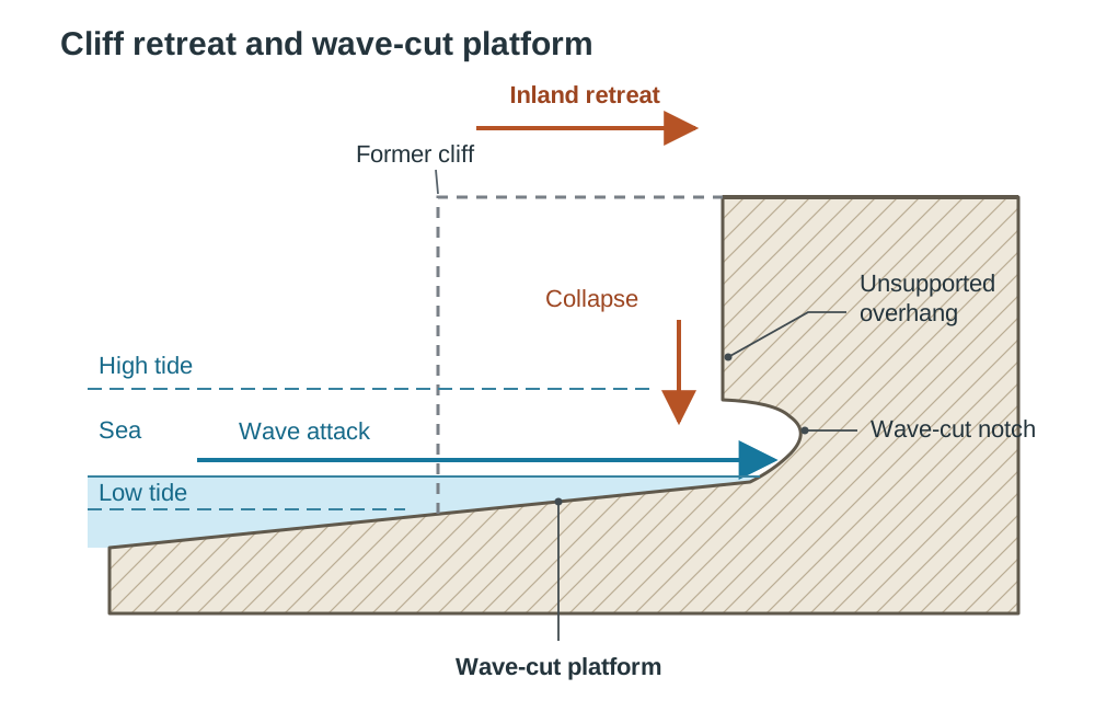
- Cliffs and wave-cut platforms: destructive waves erode a notch at the base of a cliff between high and low tide. The undercut rock above collapses under gravity. As the cliff retreats inland, it leaves a flat, rocky surface called a wave-cut platform. Irish examples: Cliffs of Moher (cliff) and Kilkee, Co. Clare (wave-cut platform).
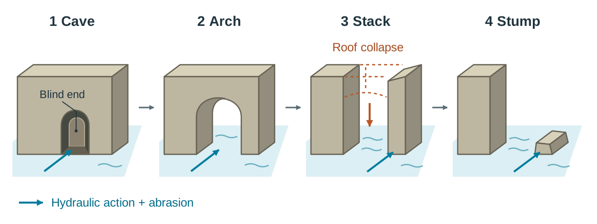
- Caves, arches, stacks, and stumps: waves attack weaknesses in a headland, hollowing out a sea cave. Erosion cuts straight through to form an arch, such as the Great Pollet Arch, Co. Donegal. When the roof collapses, an isolated pillar called a sea stack remains, such as Dún Briste, Co. Mayo. Continued erosion reduces it to a stump.
Transportation and Depositional Landforms
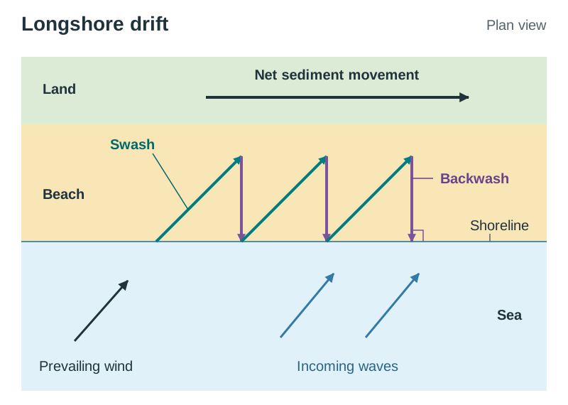
Sediment moves along coasts through longshore drift. Waves approach at an angle following the prevailing wind. The swash carries sand diagonally up the beach, then the backwash drags it straight back down the slope, so the sand moves along the coast in a zig-zag.
When waves enter shallow or sheltered water, they lose energy and deposit sediment:
| Landform | How It Forms | Irish Example |
|---|---|---|
| Beach | Constructive waves deposit sand and shingle in sheltered bays. | Ballybunion, Co. Kerry |
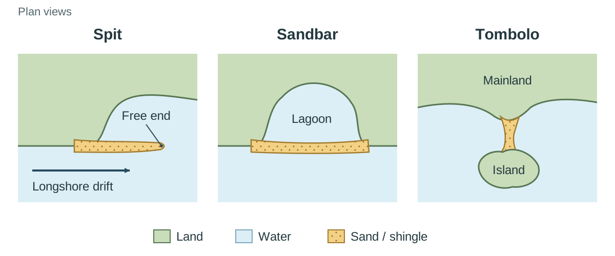
| Sand spit | A spit forms where longshore drift carries sand past a bend in the coast, building a ridge joined to the land at one end with a free end reaching into the bay. | Inch, Co. Kerry |
| Sandbar | A sandbar forms when a spit extends right across a bay, trapping a lagoon of brackish water behind it. | Lady's Island Lake, Co. Wexford |
| Tombolo | A tombolo forms when drifting sand joins an offshore island to the mainland. | Howth, Co. Dublin |
Human Interaction and Coastal Management
Fishing is a primary economic activity influenced by physical geography. Killybegs, Co. Donegal, developed as a major fishing port because of its deep, sheltered natural harbour behind headlands and its closeness to rich Atlantic fishing grounds. Rosslare Europort grew due to sheltered waters and a short sea crossing to Britain.
Coastal tourism creates jobs in hotels and shops, but visitors trampling dunes can kill marram grass, causing dunes to erode. Overfishing is managed using a quota (a legal catch limit), minimum net mesh sizes to let young fish escape, and closed breeding seasons.
To protect coasts from erosion and storm surges that cause flooding, there are two kinds of coastal protection:
- Hard engineering: artificial structures like sea walls, rock armour, or groynes that trap drifting sand.
- Soft engineering: natural methods like beach nourishment (adding sand) or planting marram grass to stabilise dunes.
Key terms
- Fetch
- The distance of open sea over which the wind blows to generate waves.
- Swash and backwash
- The swash is the water rushing up the beach when a wave breaks; the backwash is the water running back down to the sea.
- Longshore drift
- The zig-zag movement of sediment along a coast caused by waves breaking at an angle.
- Wave-cut platform
- A flat, gently sloping rock surface exposed at low tide as a sea cliff retreats inland.
- Tombolo
- A depositional ridge of sand or shingle connecting an offshore island to the mainland.
- Hard engineering
- Solid artificial structures built to block wave energy, such as sea walls and groynes.
- Soft engineering
- Coastal management approaches that work with natural processes, such as beach nourishment and marram grass planting.
- Primary economic activity
- An economic activity that extracts natural resources directly from the Earth or sea, such as fishing.
Check yourself
What two factors determine the energy and size of ocean waves?
Wind speed and the length of the fetch.
Which erosional process shatters rock when water forces air into cracks and it expands as the wave retreats?
Hydraulic action.
What coastal deposition feature forms when a spit extends right across a bay?
A sandbar.
Give one physical reason why Killybegs developed as a major fishing port.
It has a deep, sheltered natural harbour behind headlands and is close to Atlantic fishing grounds.
Name one method governments use to reduce overfishing.
Introducing fishing quotas, minimum net mesh sizes, or closed breeding seasons.