

This topic covers how river erosion, transportation, and deposition shape landscapes from source to sea, alongside human use and management of river systems. In the Junior Cycle exam, you will explain landform formation with labelled diagrams, identify river stages, and assess the economic and environmental impacts of river exploitation.
River Stages and Fluvial Processes
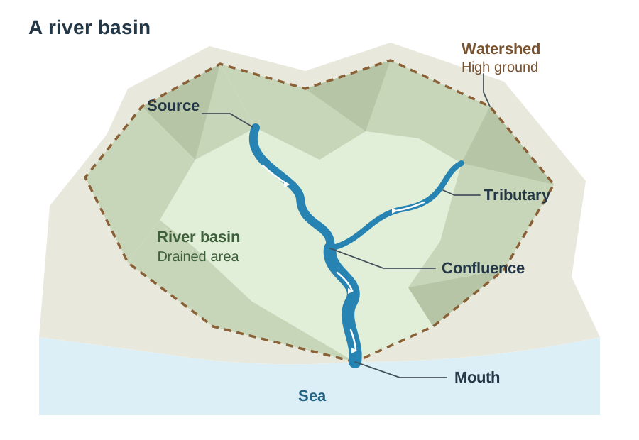
A river drains a river basin, bounded by high ground called a watershed. The source is where a river begins in upland areas, and the mouth is where it enters the sea. A smaller stream joining the main river is a tributary, meeting at a confluence.
| Course | Slope and Flow | Dominant Work | Irish Example |
|---|---|---|---|
| Upper (youthful) | Steep, fast | Vertical erosion | Upper Liffey, Co. Wicklow |
| Middle (mature) | Gentler, wider | Lateral erosion | River Moy, Co. Mayo |
| Lower (old age) | Flat, slow | Deposition | River Shannon |
There are four processes of river erosion (remember HASH):
- Hydraulic action: the physical force of moving water wearing away the bed and banks.
- Abrasion: carried stones scrape the channel like sandpaper.
- Solution: weak acids in river water dissolve soluble rocks like limestone.
- Attrition: carried stones collide, becoming smaller and rounder.
Rivers transport material by traction (rolling heavy boulders), saltation (bouncing pebbles), suspension (floating fine silt), and solution (dissolved minerals — solution is both an erosion and a transport process).
Fluvial Landforms
| Landform | Stage | Key Process | Example |
|---|---|---|---|
| V-shaped valley | Upper | Vertical erosion | Upper Liffey |
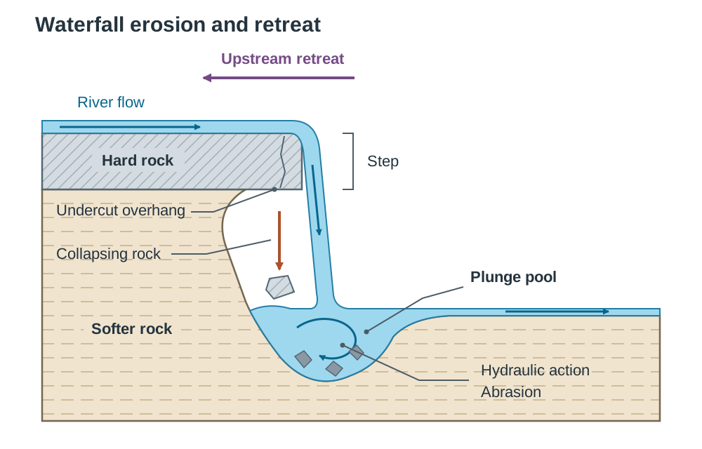
| Waterfall | Upper | Differential erosion | Torc Waterfall |
| Interlocking spurs | Upper | Vertical erosion | River Barrow |
| Meander | Middle | Erosion & deposition | River Moy |
| Oxbow lake | Middle/Lower | Deposition & erosion | River Moy |
| Levee & Floodplain | Lower | Deposition | River Barrow |
| Delta | Lower | Deposition | Nile Delta |
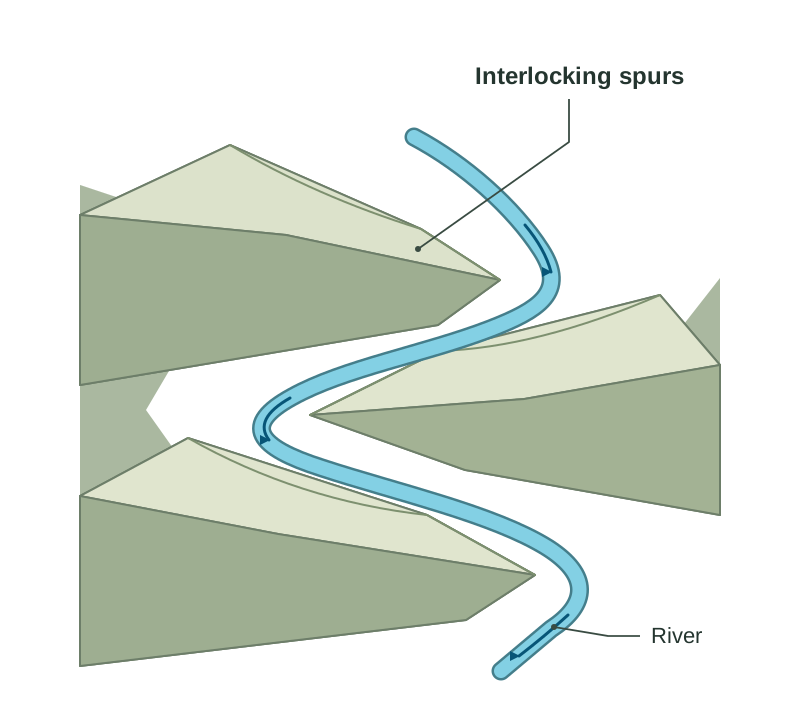
In the upper course, rivers lack energy to cut through hard rock ridges, winding around them to leave interlocking spurs that fit like the teeth of a zip.
A meander is a large bend. Fast water on the outer bank erodes a steep river cliff, while slow flow on the inside deposits sand to form a gentle slip-off slope.
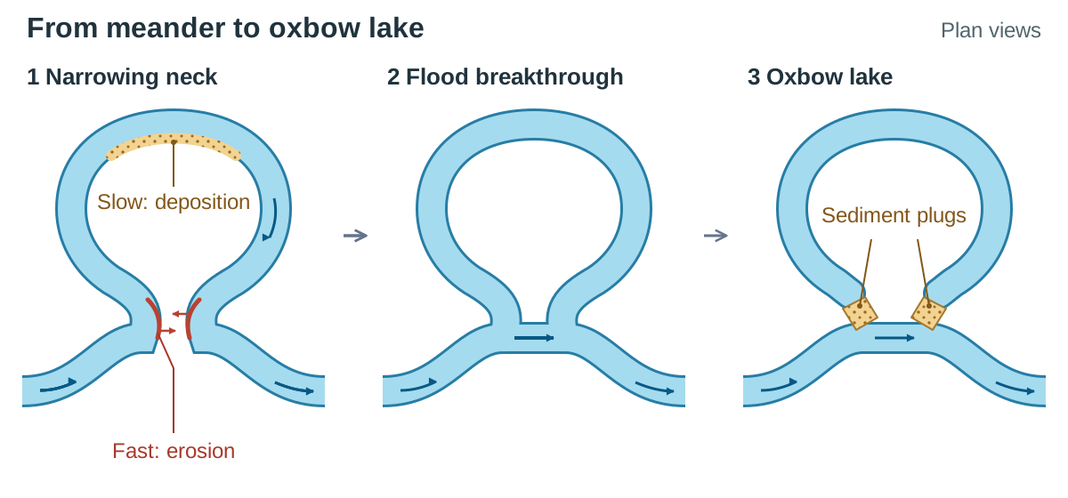
An oxbow lake forms when lateral erosion narrows a meander neck until floodwaters cut straight through. Deposition seals the ends of the abandoned loop.
A delta forms at the river mouth when flowing water loses all energy, depositing sediment in layers that rise above water level.
Rivers and Primary Activities
Physical river landscapes strongly influence primary economic activities:
- Flat floodplains covered in deep, fertile alluvium provide ideal soil for dairy and tillage farming (e.g. the Barrow valley).
- Rivers provide a reliable freshwater supply for irrigating crops, watering livestock, and food processing.
- Fast-flowing, clean rivers support commercial and recreational fishing for salmon and trout (e.g. the River Moy).
- By contrast, steep upper courses feature thin, stony soils that prevent crop growing, restricting land use to forestry or upland hill sheep farming.
River Management and Exploitation
People modify and exploit river channels for power, water, and flood defence, but this creates environmental trade-offs.
Case study — Poulaphouca Dam, Co. Wicklow:
- Built on the River Liffey, creating the Blessington Lakes reservoir.
- Positive impacts: Generates clean, renewable hydroelectric power (HEP) and supplies a large share of Dublin's drinking water.
- Negative impacts: Flooded thousands of hectares of good farmland and forced many families to leave their homes.
Water pollution from human exploitation:
- Runoff containing slurry and chemical fertilisers adds excess nitrates to rivers.
- This triggers eutrophication: rapid algae growth blocks sunlight, depletes dissolved oxygen when dying, and kills fish.
- Industrial waste and untreated sewage reduce water quality and increase the cost of producing safe drinking water.
Key terms
- Hydraulic action
- The erosion of a riverbed and banks caused purely by the physical force of moving water.
- Abrasion
- The wearing away of the river bed and banks by carried stones scraping along them.
- Slip-off slope
- A gentle slope of deposited sand and shingle formed on the slow-moving inside bend of a meander.
- Alluvium
- Fine, fertile mineral soil and silt deposited across a valley floor by river floodwaters.
- Levee
- A raised natural bank of coarse sediment built up along a river channel by repeated flooding.
- Hydroelectric power (HEP)
- Renewable electricity generated by using the gravitational force of falling river water to turn turbines.
- Eutrophication
- The over-enrichment of water by nutrients, causing algal blooms that deplete oxygen and kill aquatic life.
Check yourself
Where is a river's source generally found?
High up in mountainous or upland areas.
Give one reason why farmers choose land on a river floodplain.
The flat land and deep, fertile alluvium produce high crop and grass yields.
What process occurs when fertiliser runoff causes algae to multiply and strip oxygen from river water?
Eutrophication.
Name one positive and one negative impact of the Poulaphouca Dam scheme.
It supplies much of Dublin's drinking water, but flooded thousands of hectares of good farmland.