

Glacial landscapes are areas shaped by moving ice during the Ice Age. The exam asks you to explain how glacial erosion and deposition formed named landforms, and to say how people use and manage these areas.
Glacial Processes: Shaping the Landscape
A glacier is a large mass of moving ice that flows downhill under gravity like a bulldozer.
- Freeze–thaw weathering breaks up exposed rock above the ice: water freezes in cracks, expands by about 10%, and shatters the rock, loosening material that falls onto the glacier.
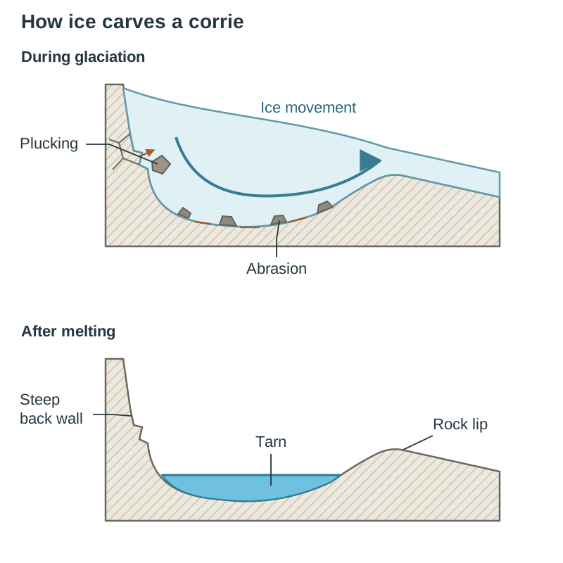
- Plucking occurs when meltwater freezes bedrock to the base of the ice, tearing chunks of rock away as the glacier moves downhill.
- Abrasion happens when embedded rocks scrape over bedrock like coarse sandpaper, gouging and smoothing the valley floor.
- Moving ice carries this rock debris downhill, transporting it within the glacier or pushing it along the margins.
Features of Glacial Erosion
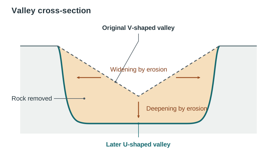
Glacial erosion reshaped upland mountain regions by turning narrow V-shaped river valleys into wide, steep-sided U-shaped valleys.
| Feature | Description | Irish Example |
|---|---|---|
| Corrie (cirque) | Armchair-shaped mountain hollow with a steep back wall, often holding a tarn | Lough Bray, Co. Wicklow |
| Arête | Knife-edged ridge carved where two neighbouring corries erode backwards | Comeragh Mountains, Co. Waterford (above Coumshingaun) |
| Pyramidal peak | Sharp mountain summit carved when three or more corries cut into the same peak | Carrauntoohil, Co. Kerry |
| U-shaped valley | Flat-floored, steep-sided valley where ice widened a river valley and cut off interlocking spurs, leaving truncated spurs | Glendalough, Co. Wicklow |
| Hanging valley | High tributary valley perched above the deepened main valley floor, often forming waterfalls | Poulanass Waterfall, Co. Wicklow |
| Ribbon lake | Long, narrow lake filling a hollow over-deepened by ice on a valley floor | Upper Lake, Glendalough, Co. Wicklow |
Features of Glacial Deposition and Connected Landscapes
Melting ice and running meltwater left distinctive depositional features across lowland Ireland.
- Boulder clay (till) is an unsorted mixture of clay, sand, and boulders dropped directly by melting ice.
- A drumlin is an oval-shaped hill of unsorted boulder clay shaped beneath moving ice sheets, found in clusters across Clew Bay, Co. Mayo.
- A terminal moraine is a ridge of unsorted rock debris marking the furthest point reached by an advancing glacier.
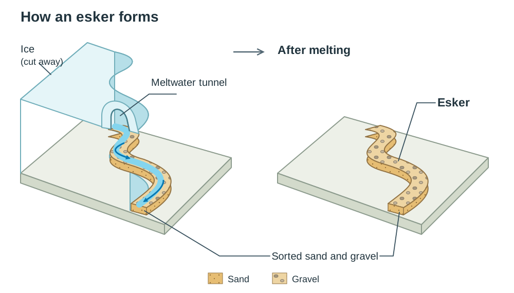
- An esker is a long, winding ridge of sorted sand and gravel left behind by a meltwater stream flowing in a tunnel beneath the ice, such as the Esker Riada.
Processes working together in one place (e.g. Westport, Co. Mayo)
- Glacial: ice carved U-shaped valleys and left boulder clay drumlins in the lowlands.
- Weathering: freeze–thaw shattered the exposed peaks, leaving loose scree on slopes.
- Fluvial: rivers later cut channels into the glacial deposits and built flood plains.
- Marine: waves eroded drowned drumlins and deposited sand as beaches.
Human Interaction and Managing Glacial Landscapes
Glacial landscapes provide resources and routeways, but high visitor numbers and heavy machinery require careful management.
| Activity | Influence of the Glacial Landscape | Economic or Environmental Impact |
|---|---|---|
| Farming | Fertile lowland boulder clay supports dairy farming, while thin upland soils limit farming to hill sheep | Provides rural income, but overgrazing on steep valley sides causes soil erosion |
| Quarrying | Eskers supply sorted sand and gravel; moraines supply mixed stone and clay | Supplies the construction industry, but quarry pits scar the landscape and create dust |
| Tourism and transport | Flat floors of U-shaped valleys offer scenery, lakes, and natural corridors for roads and railways | Creates tourism jobs, but large numbers of walkers wear away mountain paths |
Sustainable management responses
- Stone paths and raised timber boardwalks at sites such as Glendalough, Co. Wicklow protect fragile soils and vegetation from walkers' footsteps.
- Worked-out sand and gravel pits in eskers are restored into wetlands or community recreation parks once quarrying stops.
Key terms
- Plucking
- A process of glacial erosion where meltwater freezes bedrock to moving ice, tearing rock chunks away.
- Abrasion
- A process of glacial erosion where stones embedded in the base of a glacier grind and polish bedrock.
- Corrie (cirque)
- An armchair-shaped mountain hollow carved out by plucking, abrasion, and rotational ice slip.
- U-shaped valley
- A wide, flat-floored valley with steep sides formed when a glacier widens and deepens a V-shaped valley.
- Boulder clay (till)
- An unsorted deposit of clay, sand, and stones laid down directly by melting glacier ice.
- Drumlin
- A streamlined, oval hill of unsorted boulder clay deposited and shaped beneath a moving ice sheet.
- Esker
- A long, winding ridge of sorted sand and gravel deposited by a meltwater stream under a glacier.
- Sustainability
- Meeting present needs without compromising the ability of future generations to meet their own needs.
Check yourself
What is the name of the lake that often occupies an abandoned corrie basin?
A tarn (or corrie lake).
Why does an esker contain sorted sediments while a moraine contains unsorted rock?
Flowing meltwater sorts sediments by particle size and weight in a subglacial tunnel, whereas ice dumps moraines without sorting.
Name two physical processes other than glaciation that have shaped the landscape around Westport, Co. Mayo.
Weathering (freeze–thaw on the peaks) and marine action (waves eroding the drowned drumlins).
Give one sustainable way local authorities manage path erosion caused by tourists in glacial valleys.
Building stone pitched paths and raised wooden boardwalks to protect the soil from walkers' footsteps.