

Fold mountains are mountain ranges formed when two tectonic plates collide and the rock layers between them are squeezed and bent upwards. For the Junior Cycle exam, you need to explain how they form using a labelled diagram, describe their global distribution and mountain-building periods, and assess their impacts on people.
How Fold Mountains Form
The Earth is made of three layers: the solid outer crust, the semi-molten mantle, and the hot metallic core. Tectonic plates are large slabs of the crust that move slowly on top of the mantle.
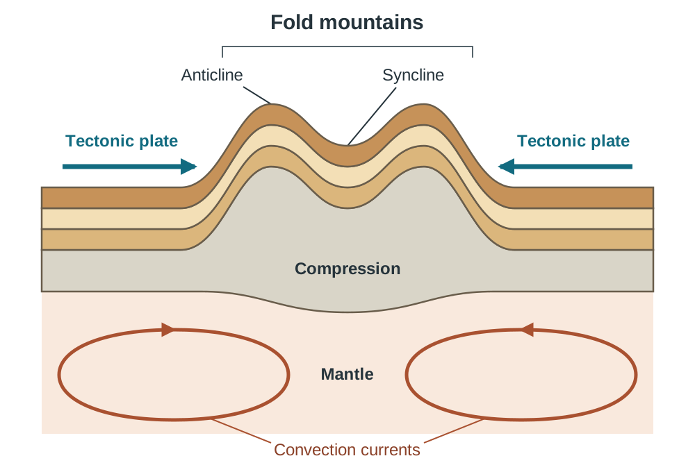
- Heat from the core generates convection currents in the mantle, slowly moving the tectonic plates.
- Two plates collide at a convergent boundary, which is also called a destructive or colliding boundary.
- Powerful compression squeezes the rock layers and sea-floor sediments caught between the colliding plates.
- Instead of breaking, these rock layers bend and buckle upwards over millions of years to create fold mountains.
Anticlines and Synclines
When rock layers are compressed during plate collisions, they bend into distinct wave-like shapes:
- An anticline is an upward arch in folded rock that forms mountain ridges and peaks.
- A syncline is a downward trough in folded rock that forms valleys.
Anticlines arch up like an A, while synclines sink down. In Munster, major rivers like the Lee and the Blackwater flow eastward through syncline valleys between parallel anticlinal mountain ridges.
Global Distribution and Orogenies
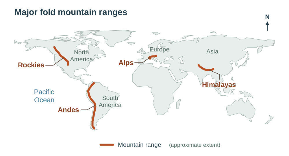
Fold mountains form in long, narrow chains along convergent plate boundaries, mostly near the edges of continents. Major ranges include the Andes in South America, the Rockies in North America, the Alps in Europe, and the Himalayas in Asia. Many of these chains ring the Pacific Ocean along the Pacific Ring of Fire, sharing the same plate boundaries as most volcanoes and earthquakes.
Periods of mountain building are known as orogenies. Older ranges have been exposed to weathering and erosion for hundreds of millions of years, making them lower and more rounded than young ranges.
| Period | Formed | Characteristics & Irish Examples |
|---|---|---|
| Caledonian | About 400 million years ago | Worn down into low, rounded peaks; Wicklow Mountains, Derryveagh Mountains |
| Armorican | About 250 million years ago | Parallel east-west ridges and valleys; MacGillycuddy's Reeks, Galtees |
| Alpine | About 30 to 35 million years ago | High, sharp, jagged peaks; Alps, Rockies, Himalayas |
Impacts on People
Fold mountain landscapes create both economic opportunities and physical challenges:
- Pastoral farming: Steep slopes and thin, acidic soils prevent crop farming, so farmers graze sheep and cattle on upland pastures.
- Coniferous forestry: State agencies like Coillte plant evergreen conifers (such as Sitka spruce) on poor upland soils because they tolerate cold, wet weather.
- Tourism: Dramatic scenery attracts hill walkers and climbers, supporting local businesses like hotels and outdoor shops.
- Transport and settlement barriers: Steep ridges force roads through winding passes, and freeze-thaw action damages road surfaces. Harsh upland weather means towns avoid the peaks and cluster in valleys.
The Himalayas in Nepal show these extreme impacts. Ongoing plate collision causes severe hazards, including the 2015 magnitude 7.8 earthquake and deadly landslides. However, tourism provides essential income through Mount Everest climbing permits and employment for Sherpa guides.
Key terms
- Fold Mountains
- Mountain ranges formed when tectonic plates collide and compress rock layers upwards.
- Convergent Boundary
- A plate boundary where two tectonic plates collide, also known as a destructive boundary.
- Convection Currents
- Slow circular movements of hot, semi-molten rock in the mantle, driven by heat from the core, which drag tectonic plates along.
- Anticline
- An upward arch in folded rock layers that forms mountain ridges and peaks.
- Syncline
- A downward trough in folded rock layers that forms valleys.
- Orogeny
- A major geological time period of mountain building caused by tectonic plate collisions.
- Pastoral Farming
- Farming focused on grazing livestock, such as sheep and cattle, rather than growing crops.
Check yourself
Name the three internal layers of the Earth from outside to inside.
Crust, mantle, and core.
Where in the world are fold mountains found?
In long chains along convergent plate boundaries, mostly near continental edges, such as the Andes, Rockies, Alps, and Himalayas.
What is the difference between an anticline and a syncline?
An anticline is an upward fold forming a mountain peak or ridge, while a syncline is a downward fold forming a valley.
Which mountain-building period formed the Wicklow Mountains?
The Caledonian folding period, about 400 million years ago.
Why do upland farmers practise pastoral farming rather than growing crops?
Steep slopes, thin acidic soils, and cold, wet weather make crop machinery impossible, but sheep and cattle can graze the terrain.