

Urban land use examines how space inside cities is organised, contested, and reshaped over time. In Leaving Certificate Geography, this topic covers the functional zones of the city, land values and Bid Rent Theory, the decentralisation of commercial and industrial activities, residential social stratification, the outward pressure of urban sprawl on rural land, and the cycles of inner-city decay and regeneration, illustrated through Dublin.
Urban Land-Use Zones and Spatial Models
Cities do not grow by accident. Their activities cluster into distinct zones shaped by accessibility, land costs, and planning policy. Geographers recognise five main land uses in a city:
- Commercial: Centred on the Central Business District (CBD), where high-order retail, financial headquarters, legal firms, and government departments cluster. Land is used intensively, resulting in multi-storey buildings and high vertical densities.
- Industrial: Older industries originally developed along waterways, canals, and docks, such as the Guinness Brewery at St James's Gate. Modern manufacturing and distribution depots have relocated outwards to suburban business parks along motorway corridors.
- Residential: Occupies the largest share of urban land. It exhibits a clear density gradient, stepping down from high-density apartments and terraced homes in inner districts to low-density semi-detached and detached homes with private gardens in outer suburbs.
- Transport: Includes radial rail and bus routes, tramways, orbital bypasses like the M50 motorway, port docks, and airport infrastructure. Transport routes occupy significant space and heavily influence the commercial value of adjacent land.
- Recreational and Open Space: Public parks, playing fields, canals, and civic squares that protect air quality and public health, such as Dublin's Phoenix Park and St Stephen's Green.
Classic Urban Land-Use Models
Geographers developed three classic models to describe how these zones arrange themselves. While no modern city matches any model perfectly, they offer useful frameworks:
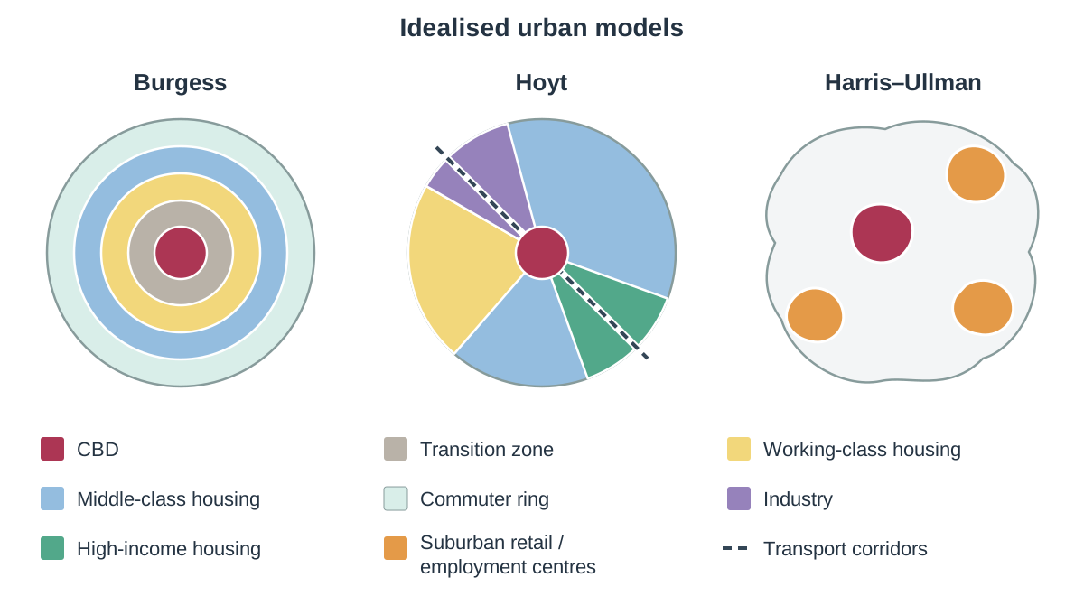
- Concentric Zone Model (Burgess, 1925): Envisages a city growing outwards in concentric rings from the CBD, followed by a zone of transition (older industry and decaying housing), low-income working-class housing, middle-class suburban housing, and an outer commuter ring. It assumes land values drop steadily away from the centre.
- Sector Model (Hoyt, 1939): Proposes that land uses expand outward in wedges along major transport corridors. Heavy industry grows along railways or river estuaries, while high-income residential areas expand outwards along scenic or clean transport routes. In Dublin, affluent housing extends south-eastwards along Dublin Bay and the DART rail line through Ballsbridge, Blackrock, and Dalkey.
- Multiple Nuclei Model (Harris and Ullman, 1945): Recognises that large modern cities develop multiple growth centres rather than a single CBD. Dublin reflects this pattern: alongside the historic city centre, major suburban nodes like Tallaght, Blanchardstown, Swords, and Dundrum act as independent retail and employment centres.
Urban Land Values and Bid Rent Theory
A clothes shop on Grafton Street pays far more rent than the same shop in a suburban estate because tens of thousands of potential customers walk past its doors each day. Urban land values depend primarily on accessibility. The most accessible point in a city is usually the CBD, where radial transport routes converge.
The point of maximum accessibility and highest land value is the Peak Land Value Intersection (PLVI). Dublin does not have a single crossroads PLVI; instead, it features twin retail axes on opposite sides of the River Liffey: Henry Street on the Northside and Grafton Street on the Southside. Prime retail rents on Grafton Street are among the highest in Europe, commanding thousands of euro per square metre annually.
William Alonso's Bid Rent Theory explains how different land users compete for urban space based on what rent they can afford to pay relative to distance from the CBD:
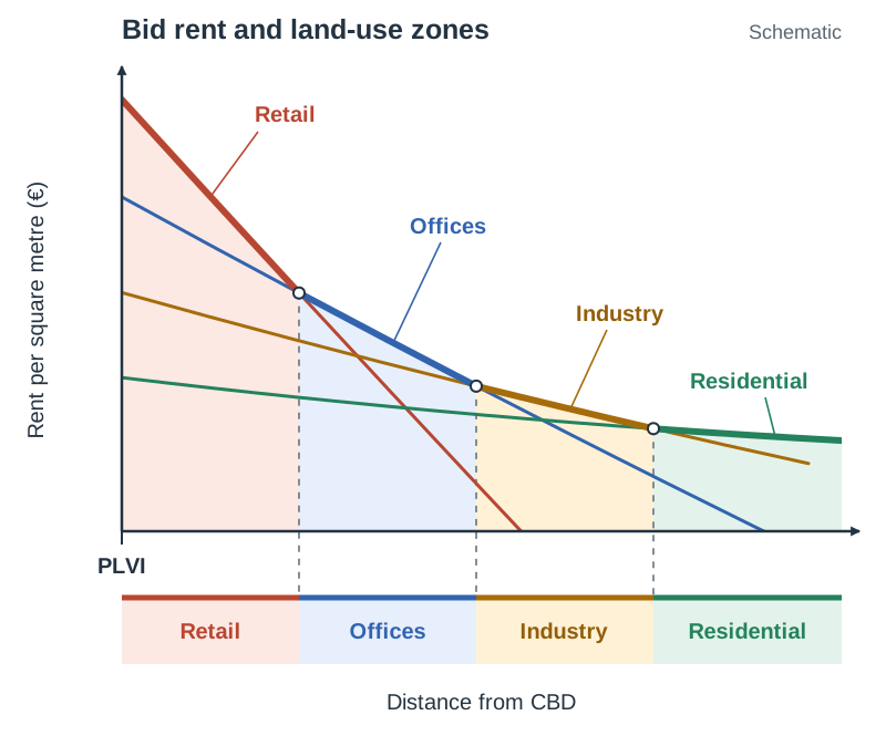
- Retail: Has the steepest bid rent gradient. Retailers rely on heavy customer footfall to generate high turnover, so they outbid all other users for ground-floor space at the PLVI. To manage high rents, department stores build vertically, using basements for retail trading and upper storeys for administration.
- Offices and Professional Services: Display an intermediate gradient. Law firms, accountancy practices, and corporate offices need high accessibility to clients and workers, but do not depend on casual window shoppers. They occupy upper floors in the CBD or locate on its fringes, such as converted Georgian buildings around Merrion Square.
- Industry and Manufacturing: Form a flatter gradient. Modern manufacturing uses single-storey assembly lines and needs extensive yards for articulated lorries. Because factories generate relatively low profit per square metre of land, they cannot compete for central land and locate on cheaper land along peripheral bypasses.
- Residential: Displays the gentlest gradient overall. Private households cannot match commercial bidding power and generally choose cheaper land in the suburbs, trading travel time for larger living space and private gardens.
Constructing the Bid Rent Diagram
When drawing a Bid Rent diagram in an exam:
- Draw a vertical y-axis labelled Rent per Square Metre (€) and a horizontal x-axis labelled Distance from the CBD.
- Mark the PLVI at the origin point where the axes meet.
- Draw four downward-sloping curves starting from the y-axis: the retail curve starts highest and drops most steeply; the office curve starts lower and has an intermediate slope; the industry curve starts lower again and is flatter; the residential curve starts lowest and is the flattest, extending furthest outwards.
- Mark the points on the x-axis where each curve intersects the next. Project these intersection points down to show the resulting land-use zones: an inner retail core, an office zone, an industrial band, and an outer residential zone.
Commercial and Industrial Land-Use Movement
Land use in a modern city is never static. Economic pressures, technology, and transport improvements cause activities to migrate across urban space.
Commercial Decentralisation
Commercial activity has increasingly moved out from traditional city centres towards suburban fringes, driven by traffic congestion and high rents:
- Retail Decentralisation: From the 1990s, large planned shopping centres were built at suburban junctions along the M50 motorway. Examples include The Square in Tallaght (1990), the Blanchardstown Centre (1996), Liffey Valley (1998), and Dundrum Town Centre (2005). These developments offer all-weather shopping, multi-screen cinemas, and thousands of free parking spaces, drawing trade away from traditional high streets. Bulky-goods retail parks (furniture, DIY, electronics) also established themselves at motorway exits where large sites are cheap.
- Office Decentralisation: Corporate employment moved out of congested Georgian quarters towards purpose-built suburban business parks such as Sandyford, Citywest, Eastpoint, and Park West. These parks provide large open-plan office floors, dedicated parking, and direct M50 access. Simultaneously, high-tech office clusters developed in the regenerated Docklands (the IFSC and the 'Silicon Docks' around Grand Canal Dock, accommodating tech multinationals like Google and Meta).
- Planning Responses to Decentralisation: Planners responded by protecting the city-centre shopping core in the Dublin City Development Plan, upgrading streets such as Grafton Street and O'Connell Street, and improving public transport access. The Luas Red and Green lines opened in 2004, and the Luas Cross City link (2017) joined them in the city centre.
Industrial Relocation
Traditional inner-city manufacturing has largely relocated to outer rings. Historically, industries like brewing, distilling, grain milling, and ship repair operated in central districts close to the quays and rail termini. Today, modern logistics and production rely mainly on road freight. Companies moved to modern industrial estates in Finglas, Ballymount, and Clondalkin, where flat sites allow horizontal layouts with container bays, loading docks, and rapid motorway access.
Residential Patterns, Social Stratification, and Commuter Belts
Residential land use reflects social stratification, meaning the spatial separation of population groups based on income, social class, and property values.
Socioeconomic Contrasts in Dublin
- Higher-Income Districts: Higher-income households are heavily concentrated along the coast of Dublin Bay: Sandymount, Blackrock, and Dalkey on the Southside, and Clontarf, Sutton, and Malahide on the Northside. These areas offer scenic coastal amenities, established parks, and high-frequency public transport along the DART rail line. Property values in these postcodes remain among the highest in Ireland.
- Local Authority Housing and Lower-Income Enclaves: During the mid-twentieth century, municipal slum clearance programmes relocated thousands of inner-city families to large suburban social housing estates on the perimeter, including Ballymun in the north, Clondalkin in the west, and Tallaght in the south-west. Initially, these estates lacked matching retail, schools, and commercial employment, entrenching socioeconomic disadvantage that required decades of targeted state investment.
- Commuter Belt Growth: From the late 1990s onward, high house prices in Dublin pushed first-time buyers into surrounding counties like Kildare, Meath, and Wicklow. Rural market towns such as Naas, Ashbourne, and Greystones transformed into fast-growing suburban satellites, generating large daily commuting flows along the M1, M3, M4, and M7 corridors.
Urban Decay and Regeneration: The Dublin Docklands
When economic activities leave an inner-city district faster than new investment arrives, the area suffers urban decay—a cycle of physical deterioration, unemployment, and population loss.
Causes of Decline in the Dublin Docklands
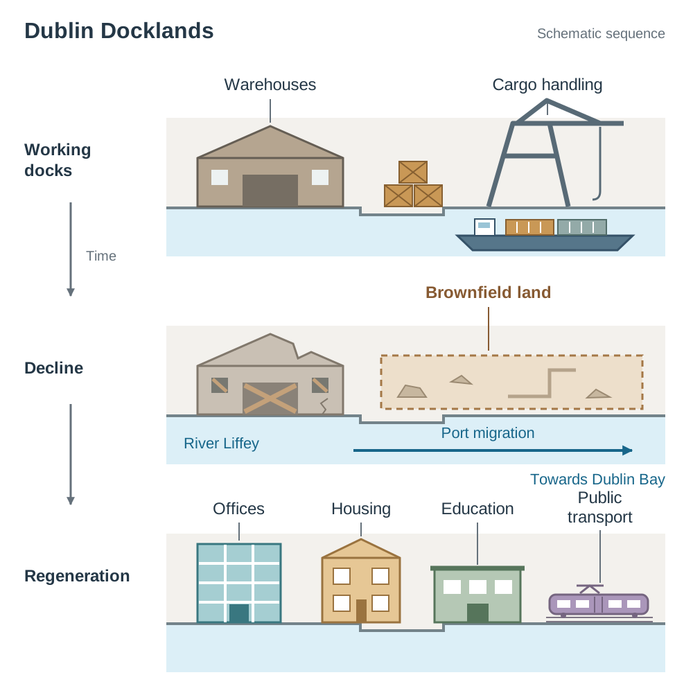
- Containerisation: From the 1960s, containerised cargo handling and roll-on/roll-off ferries replaced manual dock work. Standardised steel containers lifted by gantry cranes required far fewer labourers, eliminating thousands of traditional dockside jobs.
- Energy Transitions: Industry and residential heating switched from coal (traditionally imported through Dublin's quays from Britain) to imported oil and, from the late 1970s, natural gas from the Kinsale Head gas field. As a result, inner-city coal yards, gasworks, and rail sidings fell derelict.
- Downriver Port Migration: Modern vessels required deeper water and wide turning basins. Dublin Port moved its active operations eastwards towards Dublin Bay, leaving upstream quays abandoned.
These closures created extensive brownfield sites—previously developed land that became vacant or derelict, often with contaminated soil and decaying structures. Surrounding neighbourhoods like Sheriff Street experienced soaring unemployment, youth emigration, and rising crime.
Renewal Versus Regeneration
- Urban renewal: Improving a run-down area by refurbishing existing buildings or demolishing and rebuilding them while maintaining the original land use and keeping the community intact. Example: the Ballymun Regeneration project (1997–2017), which demolished the 1960s high-rise towers and replaced them with low-rise, modern homes for the existing community.
- Urban regeneration: A comprehensive physical, economic, and social transformation of an area that introduces entirely new land uses, modern commercial activities, and new transport infrastructure. Example: the Dublin Docklands.
Transforming the Dublin Docklands
- Phase 1: The IFSC (1987): The government designated 11 hectares of the derelict Custom House Docks as a financial enterprise zone. Through corporation tax incentives, the International Financial Services Centre (IFSC) replaced abandoned timber yards with modern office blocks, attracting over 400 international financial institutions.
- Phase 2: Dublin Docklands Development Authority (DDDA, 1997): The DDDA was given statutory planning control over 520 hectares on both sides of the River Liffey.
- Civic and Cultural Venues: Projects like the 3Arena, the Convention Centre Dublin, and the Bord Gáis Energy Theatre brought activity to the quays during evenings and weekends.
- Transport Links: The Luas Red Line was extended to The Point (2009), and the Samuel Beckett Bridge (2009) connected the north and south quays. Separately, the Dublin Port Tunnel (opened in 2006 as a national road project) diverted heavy container lorries off surface quays directly to the M50.
- Social Quotas and Education: To counter gentrification (where rising property prices displace lower-income locals), planning regulations mandated that 20% of new residential units be reserved for social and affordable housing. The National College of Ireland (NCI) was relocated into the Docklands to offer higher education and training to local residents.
Quick-Reference Fact File: Dublin Docklands
- 1987: IFSC established on 11 hectares of former Custom House Docks.
- 1997: DDDA created to regenerate 520 hectares of brownfield land.
- 20% social and affordable housing quota enforced on residential developments.
- 2006: Dublin Port Tunnel opens, removing heavy goods vehicles from the quays.
- 2009: Luas Red Line extension to The Point and Samuel Beckett Bridge completed.
- Historic industrial landmark Boland's Mills repurposed into modern commercial and residential spaces.
Heritage Preservation and Architectural Conflict
Regeneration creates tension between conservation and commercial expansion. In the 1960s, the Electricity Supply Board (ESB) demolished 16 historic Georgian houses on Lower Fitzwilliam Street to construct modern offices, provoking intense public controversy. Today, strict conservation orders protect historic streetscapes on Merrion Square and Mountjoy Square. While conservation preserves cultural heritage and supports tourism, strict planning limits can leave older buildings vacant if modern commercial uses cannot fit into historic layouts.
Urban Sprawl, Rural Pressures, and Planning Responses
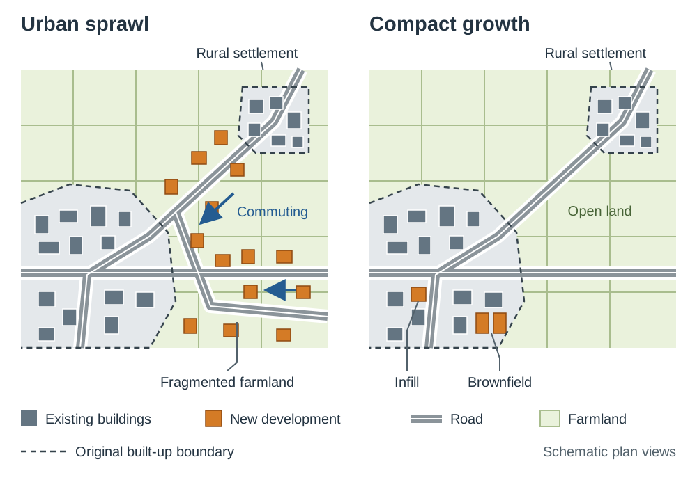
Urban sprawl is the rapid, low-density, uncontrolled outward spread of a city into surrounding rural countryside. The built-up footprint of Dublin has expanded relentlessly outward along national road routes, absorbing formerly independent rural settlements like Lucan, Clondalkin, and Swords.
Drivers of Sprawl
- High purchase and rental costs in the city push families to seek more affordable housing on greenfield sites—previously unbuilt land, such as farmland or woodland at the city's edge.
- Developers prefer greenfield sites because they are cheaper and do not need expensive site demolition or contaminated soil clean-up.
- Widespread car ownership combined with the radial motorway network (M1, M3, M4, M7) allows long-distance daily commuting.
Pressures on the Rural-Urban Fringe
- Dormitory Towns: Villages in the outer commuter belt (such as Dunshaughlin, Celbridge, and Ashbourne) became dormitory settlements. They lack proportional local employment and community services, functioning primarily as bedroom communities during the working day.
- Agricultural Land Fragmentation: New motorways, orbital link roads, and housing estates slice across established farms, leaving fields cut off or too small to work efficiently with modern agricultural machinery. Many farmers sell out to developers, accelerating sprawl.
- Increased Flood Risk: Building on greenfield land replaces permeable soil with impermeable tarmac and concrete. Rainwater cannot infiltrate the ground, which drastically shortens river lag times and increases surface runoff. For example, during November 2002, rapid development in the upper catchment of the River Tolka (covering Clonee, Dunboyne, and Blanchardstown) contributed to severe flooding downstream in Drumcondra and Richmond Road, damaging hundreds of homes built on the natural floodplain.
Irish Planning Responses to Sprawl
- National Planning Framework (Project Ireland 2040): Sets a statutory compact growth target requiring at least 50% of all new housing in Dublin and Ireland's other four cities to be delivered within their existing built-up footprints, using brownfield and infill sites rather than greenfields.
- Development Plans and Land Zoning: County councils zone land strictly. Fingal County Council uses 'Greenbelt' and 'Rural' zoning between settlements like Swords and Malahide to stop ribbon development and keep towns distinct.
- Strategic Development Zones (SDZs): Large master-planned new communities where housing, transport, and community infrastructure are delivered together. At Adamstown in south-west Dublin, an SDZ ensured a purpose-built railway station on the Kildare line opened before most homes were occupied. Similarly, the Cherrywood SDZ was planned around the Luas Green Line extension.
Reading Urban Land Use on OS Maps and Aerial Photographs
In the Leaving Certificate exam, urban questions frequently incorporate Ordnance Survey (OS) maps and aerial photographs. You should be able to identify functional zones using clear visual evidence:
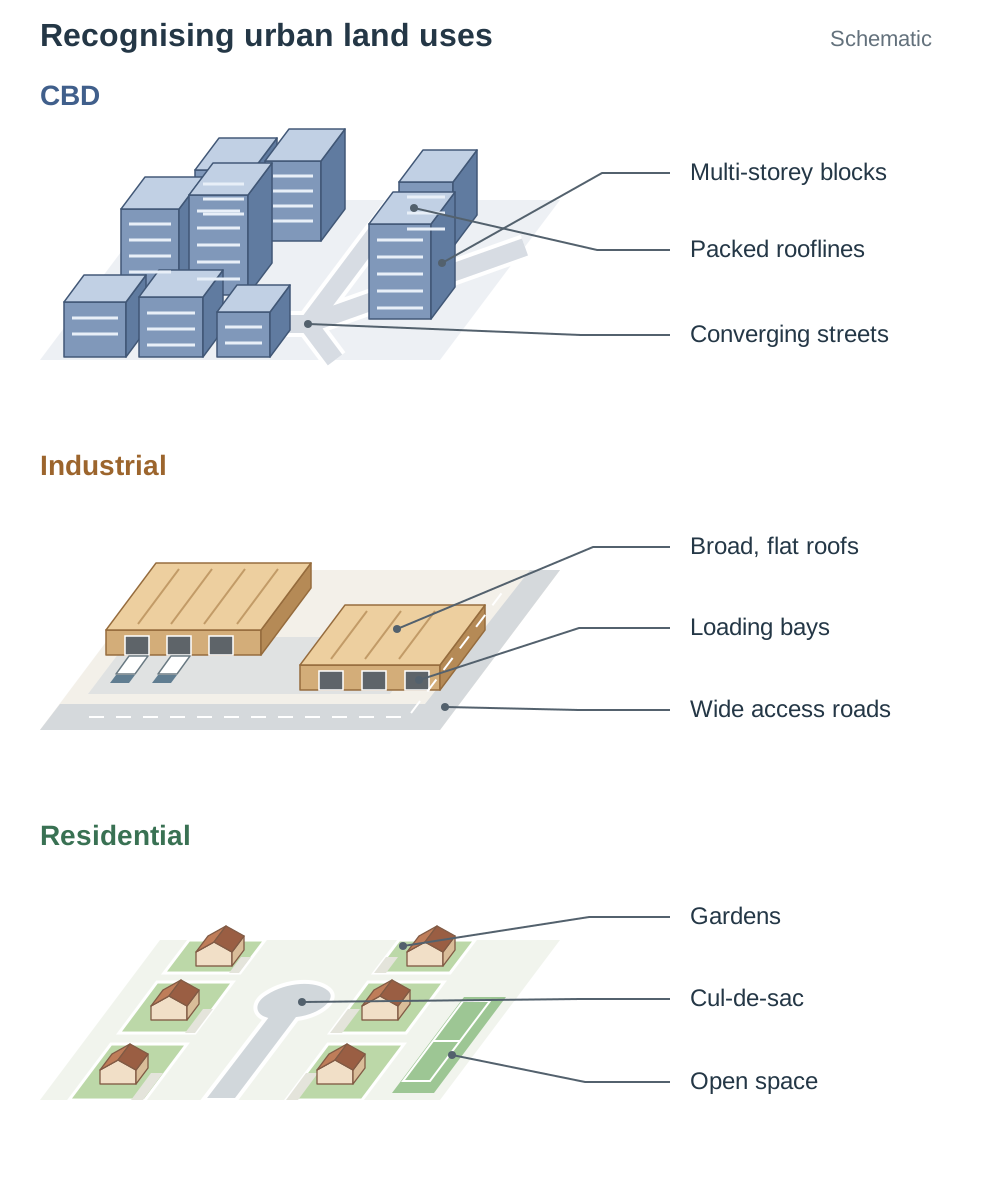
- Central Business District (CBD): On an OS map, look for a dense, converging road network with major bridges, railway termini, and public buildings (churches, museums, post offices). On an aerial photograph, the CBD shows very tall multi-storey buildings, tightly packed rooflines, pedestrianised streets, and a complete absence of private residential gardens.
- Industrial Zones: On an OS map, identified by labels such as 'Ind Est' or 'Business Park' located beside railway lines, canal basins, or outer motorway junctions. On an aerial photograph, look for extensive, single-storey flat-roofed warehouses, large lorry loading bays, car parks for workers, and wide access roads.
- Residential Suburbs: On an OS map, shown by repeated street patterns with cul-de-sacs, crescents, and green recreation spaces. On an aerial photograph, look for regular rows of semi-detached or detached houses with individual front driveways and back gardens, alongside neighbourhood schools and playing pitches.
Key terms
- Central Business District (CBD)
- The commercial, financial, and administrative heart of a city, characterised by high accessibility, peak land values, and multi-storey commercial buildings.
- Accessibility
- The ease with which a location can be reached from surrounding areas, typically highest where radial transport routes converge in the city centre.
- Peak Land Value Intersection (PLVI)
- The point within the CBD possessing the greatest accessibility and pedestrian footfall, commanding the highest commercial rents per square metre.
- Bid Rent Theory
- William Alonso's economic model showing that land users compete for urban sites based on the maximum rent they can afford relative to distance from the city centre.
- Commercial Decentralisation
- The outward movement of retail and office activities from the traditional city centre to suburban motorways, retail parks, and edge-of-city office campuses.
- Social Stratification
- The spatial separation of urban residential areas based on socioeconomic status, household income, and property values.
- Urban Decay
- The physical deterioration, economic decline, and depopulation of older inner-city areas caused by factory closures, dock relocation, and lack of investment.
- Brownfield Site
- Land that was previously built on and is now abandoned, vacant, or derelict, often requiring environmental clean-up before redevelopment.
- Greenfield Site
- Land that has never previously been built on, usually open agricultural land or natural countryside on the rural-urban fringe.
- Urban Renewal
- Improving a run-down urban area by refurbishing existing buildings or rebuilding on existing sites while keeping the original land use and community intact.
- Urban Regeneration
- A comprehensive physical, economic, and social overhaul of a declining urban area that changes land uses and introduces new infrastructure and jobs.
- Gentrification
- The process where wealthier residents move into a run-down inner-city neighbourhood, renovating properties and driving up property values, often displacing lower-income residents.
- Urban Sprawl
- The rapid, uncontrolled, low-density outward expansion of a city into surrounding rural and agricultural land.
- Dormitory Town
- A satellite settlement located on an urban fringe whose residents commute into a nearby city daily for work, leaving the town largely quiet during business hours.
- Greenbelt
- A legally designated zone of open agricultural and forested land encircling a city where building development is prohibited or strictly controlled to halt sprawl.
- Compact Growth
- A National Planning Framework (Project Ireland 2040) policy that at least 50% of new homes in Dublin and Ireland's other four cities should be built within their existing built-up footprints, on brownfield and infill sites, rather than on greenfield land.
Check yourself
What is the difference between a brownfield site and a greenfield site?
A brownfield site is land previously built on that is now vacant, derelict, or contaminated (such as disused docks). A greenfield site is open, undeveloped land, such as agricultural fields at the city edge.
According to Alonso's Bid Rent Theory, why can retail pay the highest rents at the PLVI?
Retailers rely on high pedestrian footfall to generate high sales volumes, giving them the profitability required to outbid all other land users for central space.
Distinguish between urban renewal and urban regeneration, giving a Dublin example of each.
Urban renewal improves an area while keeping the existing land use and community intact, such as replacing the high-rise flats in Ballymun with modern social housing. Urban regeneration fundamentally transforms an area by introducing new land uses and economic activities, such as converting Dublin's industrial docklands into office blocks, apartments, and cultural venues.
What is a greenbelt and what planning role does it perform?
A greenbelt is a legally protected belt of open agricultural or wooded land surrounding a city where development is strictly restricted. It halts urban sprawl, prevents towns from merging, and preserves natural drainage basins.
How did rapid urban sprawl contribute to severe flooding along the River Tolka in November 2002?
Widespread construction on greenfield sites in the upper catchment covered soil with impermeable concrete and tarmac, reducing rainwater infiltration, shortening lag time, and channeling heavy runoff rapidly into the river.
What is the compact growth target set by Ireland's National Planning Framework (Project Ireland 2040)?
It requires that at least 50% of all new housing in Ireland's five cities be built within their existing built-up footprints using brownfield and infill sites.