

Soil is the thin, loose layer covering the Earth's land surface, formed through the in situ weathering of parent rock and the decomposition of organic materials over hundreds of years. In Leaving Certificate Geoecology, soils are assessed on their physical and chemical characteristics, the five environmental factors that govern their formation, the pedogenic processes that produce distinct horizons, and the global and national patterns of soil distribution. This unit also examines severe soil degradation triggered by human activities such as overgrazing, overcropping, and deforestation, alongside sustainable soil conservation strategies.
Soil Composition: The Four Core Constituents
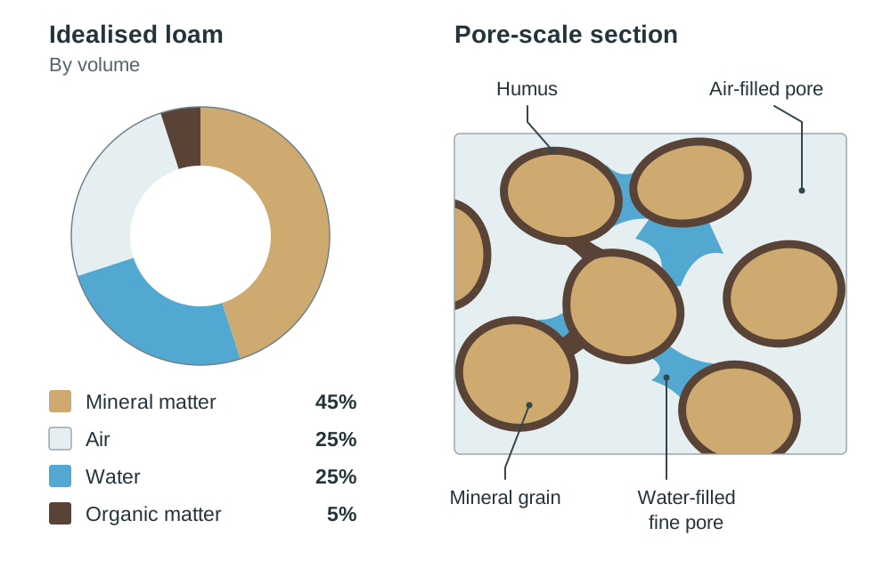
Soil is a living, fragile medium that can take several hundred years to form a single centimetre of mature topsoil. In a balanced, productive loam, the four primary constituents exist in specific proportions by volume:
- Mineral matter (45%): Derived from the physical and chemical breakdown of underlying bedrock or deposited glacial drift. Particles range in size from coarse sand down to fine silt and microscopic clay platelets. This mineral fraction supplies essential parent-rock nutrients, including calcium, magnesium, potassium, and phosphorus, which dissolve into the soil solution for root absorption.
- Air (25%): Fills the macro-pores between mineral grains and peds. It provides essential oxygen for root respiration and sustains aerobic decomposers such as burrowing earthworms and fungi. Soil air also supplies nitrogen to symbiotic, nitrogen-fixing bacteria located in plant root nodules.
- Water (25%): Stored in fine capillary pores. Soil water acts as the solvent that dissolves mineral nutrients so that plant roots can absorb them in solution. If soils become saturated or waterlogged, water expels all pore air, cutting off oxygen and forcing the environment into an anaerobic state.
- Organic matter (5%): Consists of living biomass, plant litter, fallen leaves, and decaying roots. Microorganisms break down this litter through humification to create humus: a dark, nutrient-dense, jelly-like substance that coats mineral particles, improves water retention, and binds loose grains into stable crumbs.
Physical Characteristics: Texture, Structure, and Drainage
A soil's physical properties govern root penetration, aeration, moisture retention, and workability.
Soil Texture
Texture is the proportion of sand, silt, and clay in a soil. It is inherited directly from the parent material, and farming practices cannot easily change it:
- Sandy soils: Dominated by coarse particles that create large macro-pores. They drain freely and warm rapidly in spring, but hold very little moisture and lose nutrients easily through leaching.
- Clay soils: Dominated by very fine, flat clay platelets that create tiny pore spaces. They hold large volumes of water and store abundant cations due to their electrostatic surface charges. However, they are prone to waterlogging, compact easily, and bake into hard crusts when dry.
- Silty soils: Composed of medium-sized particles that feel silky and smooth. They retain moisture reasonably well and provide good fertility, but can form a sealed surface crust under heavy rain.
- Loam soils: A balanced mixture of roughly 40% sand, 40% silt, and 20% clay. Loams are considered the ideal agricultural soil because they provide free drainage alongside reliable moisture and nutrient retention.
Field test for texture: Moisten a small ball of soil and rub it between your thumb and forefinger. Gritty and abrasive indicates sand; smooth and silky like talcum powder indicates silt; sticky, mouldable, and shiny indicates clay.
Soil Structure
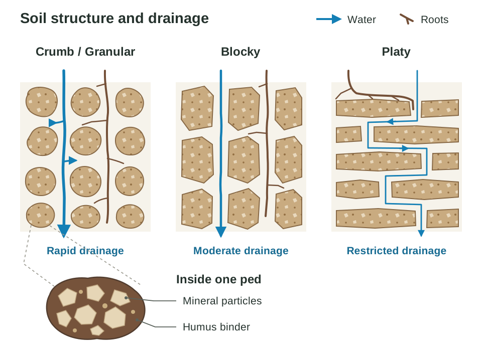
Structure describes how individual mineral particles bind with humus into distinct aggregates called peds. Unlike texture, human activity can alter soil structure rapidly:
| Ped Structure | Physical Shape | Air & Water Movement | Typical Soil Setting |
|---|---|---|---|
| Crumb / Granular | Small, rounded crumbs (1–5 mm) | Excellent; open macro-pores permit unrestricted root growth and rapid drainage | Fertile A horizons of temperate brown earth soils |
| Blocky | Angular or sub-angular blocks | Moderate; water drains down vertical ped faces | Clay-enriched B horizons of brown earths |
| Platy | Flat, horizontal overlapping plates | Poor; horizontal alignment blocks vertical infiltration and causes waterlogging | Compacted subsoils, machine-compressed surfaces, and hardpans |
Chemical and Visual Indicators: Soil pH and Colour
Soil pH Value
The pH scale runs from 0 to 14. It measures the concentration of hydrogen ions in the soil solution, controlling nutrient availability and microbial life:
- Optimal, slightly acidic to neutral (about pH 6–7): The optimal range for mixed agriculture. Earthworms and nitrifying bacteria thrive, and major plant nutrients (nitrogen, phosphorus, potassium) are most readily available to plants.
- Strongly acidic (below about pH 5.5): Common in high-rainfall regions where heavy percolation washes soluble alkaline bases downwards. In cold, wet uplands under heath or coniferous forest, severe acidity inhibits earthworms and bacteria, slowing decay into a raw, acidic mor humus.
- Alkaline (above pH 7): Found over limestone bedrock, such as the shallow rendzina-type soils of the Burren in Co. Clare, or in semi-arid regions where intense surface evaporation draws calcium carbonate upwards.
Soil Colour
Colour provides an immediate visual diagnosis of organic content, drainage status, and chemical weathering:
- Dark brown or black: Indicates high mull humus content and active biological recycling, typical of undisturbed brown earth A horizons.
- Red or orange-brown: Indicates unhydrated iron oxides (ferric oxide) formed under warm, oxidising, well-drained conditions, as seen in tropical latosols.
- Bleached ash-grey or white: Signifies severe eluviation (washing out). Soluble minerals, organic matter, and iron compounds have been stripped from the leached A2 horizon of a podzol, leaving behind bare quartz sand.
- Mottled blue-grey or greenish: Signifies persistent waterlogging and anaerobic conditions. Deprived of free oxygen, anaerobic bacteria reduce ferric iron to soluble ferrous compounds, producing the blue-grey colour characteristic of gley soils.
Weathering and the Factors Affecting Soil Formation
Soil formation begins with weathering, which is the breakdown of rock in situ without the rock being moved. It supplies all primary mineral matter:
- Mechanical (physical) weathering: Freeze-thaw action prises rocks apart when water enters fissures, freezes, and expands by roughly 9%. This occurs widely on exposed Irish uplands like the Macgillycuddy's Reeks.
- Chemical weathering: Rainwater absorbs carbon dioxide to form weak carbonic acid, dissolving limestone bedrock through carbonation (as seen in the Burren). Hydrolysis alters feldspar minerals in granite into clay, while oxidation reacts with iron-bearing minerals to produce rust-red iron oxides.
- Biological weathering: Plant roots penetrate bedding planes, and organic acids released by decaying mosses and lichens weaken mineral bonds.
Five distinct environmental factors control what kind of soil develops in any location:
1. Parent Material
Parent material determines soil mineralogy, initial texture, and base chemical properties. Granite weathers into coarse, quartz-rich, acidic sandy soils (e.g. the Wicklow Mountains), whereas shale produces fine-grained clay soils with slower drainage. Pure limestone produces alkaline, calcium-rich soils. Across Ireland, most agricultural soils did not develop directly from solid bedrock, but rather on transported glacial drift (boulder clay) deposited at the end of the last Ice Age.
2. Climate
Climate is the primary control at a regional and global scale. Rainfall volume governs whether water moves downwards through leaching or upwards through capillary action. Temperature controls the speed of chemical weathering and organic decomposition; weathering rates roughly double for every 10°C rise in temperature. Hot, humid equatorial climates therefore produce soils that are tens of metres deep, whereas cold polar climates support only thin, poorly weathered profiles.
3. Living Organisms
Vegetation, animals, and microorganisms dictate organic input and structural mixing. Broadleaf deciduous trees (oak, ash) provide nutrient-rich leaf litter that breaks down into mildly acidic to near-neutral mull humus. Coniferous forests drop resinous needles that break down into acidic mor humus. Earthworms ingest mineral grains and organic residues, aerating the profile and producing water-stable crumb peds. Humans also act as powerful biological agents through drainage, ploughing, liming, and fertilisation.
4. Topography (Relief)
Slope angle, elevation, and aspect control drainage, erosion rates, and local microclimates. Steep slopes suffer rapid runoff and soil creep, preventing deep profile accumulation and keeping soils thin. Low-lying, flat plains collect eroded sediments to build deep profiles, but can develop waterlogged gley soils if drainage basins lack natural outlets. South-facing slopes receive higher solar radiation, warming faster and accelerating microbial activity.
5. Time
Soil formation is an exceptionally slow chronological process. Mature soils exhibit fully differentiated, distinct horizontal layers (horizons). Immature soils, such as fresh river alluvium, coastal sand dunes, or recent volcanic ash falls, have had insufficient time to develop defined layers. Most Irish soils are postglacial and relatively young, having formed within the last 10,000 to 12,000 years following ice sheet retreat.
Pedogenic Processes Shaping Soil Horizons
A soil profile develops distinct horizontal layers (O, A, B, and C horizons) through specific soil-forming (pedogenic) processes:
- Humification: The biological conversion of raw plant and animal remains into dark, colloidal humus by bacteria and fungi. (Note: the syllabus term "humidification" refers to this exact process.) In mild deciduous environments with high earthworm numbers, rapid humification produces rich mull humus thoroughly mixed into the upper topsoil.
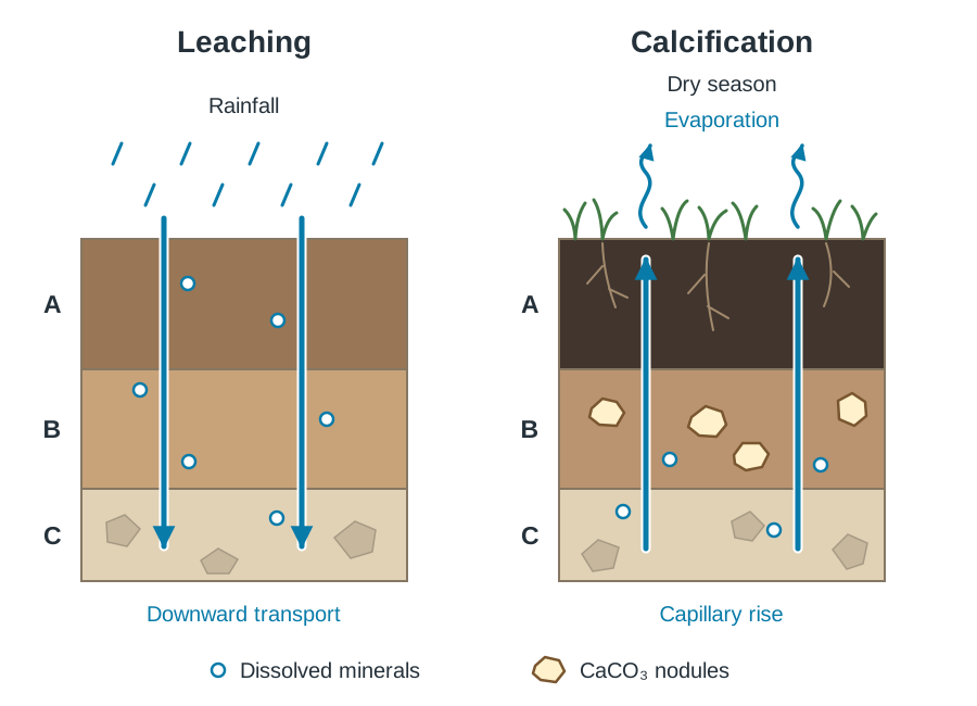
- Leaching: The downward removal of dissolved nutrients, soluble minerals, and basic cations (such as calcium and potassium) by percolating water when precipitation exceeds evapotranspiration.
- Podzolisation: An intense form of leaching common in cool, wet upland climates under coniferous forests or heather moorland (e.g. the conifer plantations of the Wicklow Mountains). Highly acidic water derived from mor humus leaches iron and aluminium sesquioxides and clays from the upper mineral soil. This leaves behind a bleached, ash-grey leached A2 horizon (also called the E horizon). Lower in the profile, these sesquioxides precipitate in the B horizon, cementing mineral grains into an impermeable, hard rusty layer known as an ironpan. The ironpan halts vertical drainage and causes surface waterlogging.
- Laterisation: Operates in hot, humid equatorial climates with heavy rainfall (e.g. the Amazon and Congo basins). High temperatures accelerate chemical weathering, breaking down silicates and leaching them deep underground. Insoluble iron and aluminium oxides remain in the upper layers, accumulating to form deep, red, nutrient-poor latosols. (If you study the tropical rainforest biome, laterisation represents the soil section of your biome study.)
- Calcification: Occurs in temperate grasslands such as the Ukrainian steppes and the North American prairies, where precipitation is low (250–500 mm) and evapotranspiration is high. Grass roots draw calcium up from the subsoil and return it in decaying leaves, producing a deep, dark, fertile, calcium-rich soil called a chernozem (black earth). In dry seasons, capillary action draws calcium carbonate upward, where it precipitates as nodular deposits in the B horizon.
- Gleying: Takes place under anaerobic conditions where soils are permanently waterlogged due to high water tables or impermeable subsoils (e.g. the heavy drumlin soils of Co. Leitrim and Co. Cavan). Deprived of oxygen, anaerobic bacteria reduce ferric iron to soluble ferrous compounds, creating a mottled, blue-grey subsoil.
Irish Soil Profile: The Brown Earth
The brown earth is Ireland's most widespread and agriculturally productive soil type. It dominates the lowlands of the Midlands, south, and east (e.g. Co. Meath, Co. Kildare, and Co. Kilkenny).
Environmental Conditions and Formation
- Climate: Cool temperate oceanic climate with moderate rainfall (750–1,200 mm annually) and mild seasonal temperatures. Leaching occurs, but it is moderate and does not strip all nutrients.
- Vegetation: Natural postglacial deciduous woodland consisting of oak, ash, and hazel, which supplies large quantities of nutrient-rich leaf litter.
- Parent Material: Most frequently glacial drift or limestone-derived boulder clay.
Horizon Sequence
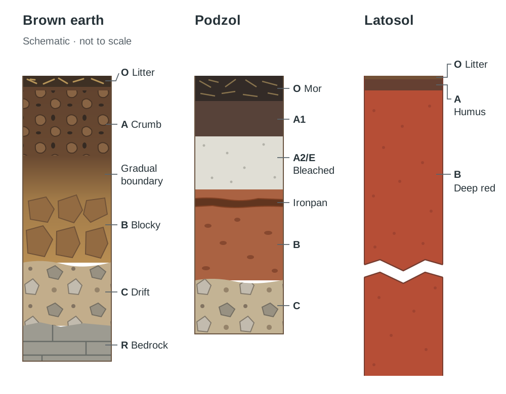
- O horizon: A thin surface layer of freshly fallen deciduous leaves, twigs, and semi-decomposed plant litter that breaks down rapidly each spring.
- A horizon (topsoil): Dark brown, deep, and rich in mull humus. It has a well-developed crumb structure with abundant macro-pores. Earthworms actively burrow through this layer, thoroughly mixing organic material with mineral particles. Its pH is slightly acidic (pH about 5.5–6.5).
- B horizon (subsoil): Lighter yellowish-brown. Minerals, iron oxides, and fine clays that have washed down from above accumulate here through illuviation. It has a firmer blocky structure.
- C horizon: Weathered parent material consisting of broken rock fragments, gravel, and unweathered glacial till.
- R horizon: Solid bedrock (often Carboniferous limestone).
Because earthworms constantly mix the profile, the boundaries between the A and B horizons are gradual and indistinct, with no sharp leached bands or ironpan formation.
Profile comparison (mental sketch):
- Brown Earth: Thin O layer thick, dark brown crumb A horizon lighter brown blocky B horizon weathered C drift.
- Podzol: Acidic mor O layer dark acidic A1 bleached ash-grey A2 thin, dark, hard ironpan reddish-brown illuviated B horizon C parent material.
- Latosol: Very thin O litter layer (recycled in weeks) thin humus layer very deep, continuous brick-red B horizon extending metres down.
The Global Pattern of Soils
Globally, soils are classified into three major categories based on their primary formative controls:
Zonal Soils
Zonal soils are mature soils that have developed in direct response to broad, regional climatic and vegetational belts over long periods. Moving from the equator to the poles, zonal soils mirror climatic shifts in rainfall, temperature, and leaching rates:
- Latosols (ferralsols): Found in hot, wet equatorial biomes (e.g. the Amazon Basin). Intense laterisation and leaching produce deep, red, silica-depleted soils.
- Chernozems (black earths): Found in semi-arid temperate grasslands (e.g. the North American prairies and Eurasian steppes). Weak leaching and high grass-root turnover create deep, black, calcium-rich, highly fertile soils through calcification.
- Brown earths: Found in cool temperate deciduous forest zones across western Europe, including Ireland. Moderate leaching and rapid biological mixing produce fertile, brown, crumb-structured loams.
- Podzols: Found in cold, humid boreal (taiga) coniferous forest belts across Scandinavia, Canada, and northern Russia. Intense podzolisation produces a bleached, acidic, infertile profile with a dense subsoil ironpan.
- Tundra soils: Found in Arctic regions bordering the polar ice caps. Characterised by permafrost, low biological activity, and waterlogged summer surfaces.
Intrazonal Soils
Intrazonal soils are soils whose characteristics are governed by a distinct local factor—such as unusual parent material, relief, or poor drainage—rather than regional climate:
- Gley soils: Dominated by topography and poor drainage, causing continuous waterlogging and anaerobic reduction in low-lying hollows (e.g. inter-drumlin swales in Co. Cavan).
- Rendzinas: Shallow, alkaline, dark soils developed directly over limestone parent material where chemical weathering dissolves carbonates, leaving thin organic profiles (e.g. the Burren).
- Peat soils (histosols): Dominated by extreme waterlogging and acidic conditions that halt microbial breakdown, allowing partially decayed vegetation to accumulate into thick blanket or raised bogs.
Azonal Soils
Azonal soils are immature, poorly developed soils that lack distinct horizon differentiation because they have not had sufficient time to form:
- Alluvial soils: Formed from fresh silts and sands periodically deposited by river floodwaters along active floodplains.
- Regosols and Lithosols: Thin screes of recently shattered bedrock on steep mountain peaks, or active coastal sand dunes shifting under maritime winds.
Human Interference: Degradation in the Sahel and the Burren
Human land use can rapidly destabilise natural soil systems, triggering topsoil loss, physical compaction, and desertification.
The African Sahel: Semi-Arid Degradation
The Sahel is a semi-arid savanna belt over 5,000 km long, stretching from Senegal on the Atlantic coast to Sudan and Eritrea on the Red Sea. It receives a sparse, erratic annual rainfall of 200 mm to 600 mm during a brief summer wet season.
- Overgrazing: Rapid population growth (approaching 3% annually) led to expanding livestock numbers. The installation of deep boreholes encouraged nomadic pastoralists to settle permanently. Continuous grazing around these wells exceeded the pasture's carrying capacity. Animal hooves exerted intense pressure, crushing rounded crumb peds into flat platy structure peds. This destroyed soil pores and reduced infiltration, so sudden convective rains washed topsoil away in sheetwash erosion.
- Overcropping: To service international debts, governments encouraged continuous cash-crop monocultures of groundnuts and cotton. Farmers abandoned traditional fallow cycles. Each harvest stripped nitrogen, phosphorus, and potassium without replacement. Continuous ploughing exposed the soil to microbial oxidation. As humus levels fell, mineral particles lost the organic glue that binds them into crumbs. The topsoil broke down into loose, powdery grains that were easily blown away by dry northeast Harmattan winds.
- Deforestation: Wood supplies over 80% of rural household cooking fuel. Trees are cut down far faster than natural regeneration rates, stripping windbreaks and root anchors across millions of hectares. Left bare, topsoils dry out, and desert margins advance southwards by 5 to 10 km per year.
The Burren, Co. Clare: Historical Degradation in Ireland
The Burren provides an Irish example of severe human-induced soil loss on a sensitive limestone landscape:
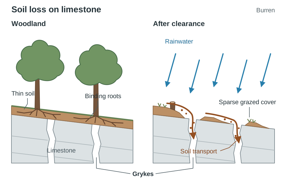
- Pre-clearance woodland: Following the retreat of the glaciers, the Burren's limestone bedrock was covered by a thin layer of glacial drift and fertile, well-drained brown earth soil, supporting hazel, pine, and birch woodland.
- Neolithic clearance: Around 6,000 years ago, Neolithic and Bronze Age pastoralists cleared the upland woodlands to open pasture for cattle and sheep. The Poulnabrone portal tomb (dated to c. 3,600 BC) marks this prolonged period of prehistoric agricultural settlement.
- Erosion mechanism: Stripped of woodland root networks and protective canopy cover, the thin topsoil was exposed to heavy Atlantic rainfall (up to 1,800 mm annually). Overgrazing kept vegetative cover cropped to the roots. Rain wash and wind stripped the loose soil and flushed it down into widening limestone fissures (grykes).
- Permanent loss: Pure limestone dissolves chemically through carbonation, leaving behind very little insoluble mineral residue. Consequently, once washed away, soil takes millennia to reform. The bare limestone pavements and karren landforms seen today are largely the enduring result of this early agricultural soil erosion.
Soil Conservation and Management Strategies
To counteract human-induced soil degradation, targeted mechanical, biological, and agricultural conservation strategies must be deployed:
Sahelian Remediation Techniques
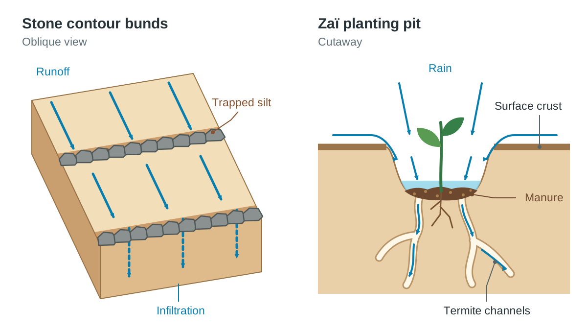
- Stone contour bunds (Diguettes): Long lines of local stones built across sloping fields along natural contour lines. Diguettes slow downslope runoff during violent storms, giving rainwater time to soak into the soil and trapping nutrient-rich eroded silt.
- Zaï planting pits: Farmers dig shallow pits (20–30 cm wide) through hard, crusted surfaces and place handfuls of manure inside before planting seeds. The pits concentrate scarce rain, while the manure attracts burrowing termites whose channels perforate the compacted soil and reopen vertical infiltration routes.
- The Great Green Wall initiative: An ambitious programme creating a planned 8,000 km belt of drought-tolerant trees (such as Acacia senegal) stretching from Senegal to Djibouti. The trees serve as windbreaks against the Harmattan, increase shade, drop leaf litter to rebuild humus, and bind the soil with root systems.
General and Temperate Soil Conservation
- Contour ploughing and terracing: Plowing across slopes rather than up and down prevents furrows from turning into water gullies. On steep hillsides, cutting stepped terraces slows runoff and holds moisture.
- Crop rotation and cover crops: Alternating crops and introducing nitrogen-fixing legumes (such as clover or field beans) restores nitrogen naturally and preserves crumb structure without synthetic chemicals.
- Restorative grazing programmes: The Burren Programme (developed from BurrenLIFE) introduced controlled winterage grazing. Rather than overstocking fragile uplands in summer, cattle graze the limestone pastures during winter, feeding on coarse grasses and keeping scrub in check without damaging soil structure.
- Shelter belts and afforestation: Planting rows of deciduous or coniferous trees across the margins of arable fields reduces surface wind velocity, preventing wind erosion and moisture loss.
Key terms
- Humus
- A dark, nutrient-dense, amorphous organic substance produced when microorganisms decompose plant litter and animal residues.
- Soil Texture
- The relative proportion of sand, silt, and clay mineral particles present in a soil sample, inherited from the parent material.
- Peds
- Individual soil particles bound together with humus into naturally occurring aggregates, classified as crumb, blocky, or platy.
- Leaching
- The downward washing and dissolution of soluble nutrients and basic minerals through the soil profile by percolating rainwater.
- Podzolisation
- An intense leaching process in cold, wet climates under coniferous or heath vegetation where acidic drainage strips iron and aluminium, leaving a bleached A2 horizon.
- Ironpan
- An impermeable, cemented layer formed in the B horizon of podzols by illuviated iron compounds that blocks drainage and root penetration.
- Brown Earth
- A fertile, mature, well-drained Irish zonal soil developed under deciduous forest with a crumb structure and rich mull humus.
- Latosol
- A deep, intensely leached, brick-red soil rich in iron and aluminium sesquioxides, formed by laterisation in tropical rainforest biomes.
- Chernozem
- A deep, black, calcium-rich, highly fertile zonal soil formed under temperate grasslands by calcification.
- Gleying
- The biochemical reduction of iron from ferric to ferrous forms under waterlogged, anaerobic conditions, producing a mottled blue-grey horizon.
- Overgrazing
- Exceeding the carrying capacity of pastureland with livestock, stripping protective vegetation, compacting crumb structure into platy peds, and accelerating runoff.
- Desertification
- The progressive destruction of biological productivity in arid and semi-arid drylands caused by climatic variability and human overexploitation.
Check yourself
What are the volumetric percentages of the four constituents in a healthy loam soil?
45% mineral matter, 25% air, 25% water, and 5% organic matter.
Name the five environmental factors that control soil formation.
Parent material, climate, living organisms, topography (relief), and time.
Describe the main characteristics of the A horizon in an Irish brown earth.
It is dark brown, deep, rich in mull humus, slightly acidic (pH about 5.5–6.5), thoroughly mixed by earthworms, and exhibits a well-aerated crumb structure.
How does livestock overgrazing change soil structure and affect surface hydrology?
Heavy animal hooves crush rounded crumb peds into flat platy peds, closing off macropores, reducing infiltration, and forcing rainwater to run off as sheetwash that erodes topsoil.
Why did tree clearance in the Burren lead to permanent soil loss rather than natural regeneration?
Heavy Atlantic rain washed the thin drift topsoil down into grykes, and pure limestone dissolves chemically through carbonation, leaving behind almost no insoluble mineral residue to rebuild new soil.
How do zaï planting pits and diguettes conserve soil in the Sahel?
Diguettes (contour stone lines) slow surface runoff and trap eroded silt, while zaï pits catch scarce rainwater and use manure to attract burrowing termites that open vertical drainage channels through compacted crusts.