

Settlement examines where people live, why communities originated in specific locations, and how towns and cities grow over time. In the Junior Cycle exam, you will classify settlements, explain origin factors using map evidence, and explain the causes and effects of urban change in an Irish town or city.
Rural and Urban Settlement Patterns
Classifying Settlement Evidence
On maps and aerial photographs, settlements are classified as rural or urban using visible landscape clues:
| Urban evidence | Rural evidence |
|---|---|
| Housing estates with many houses close together | Isolated farmhouses with large gaps between them |
| Shops, shopping centres or large car parks | Fields, hedgerows, farm sheds and silage pits |
| Street lighting, footpaths and a street network | Narrow roads with no footpaths |
Settlement Patterns
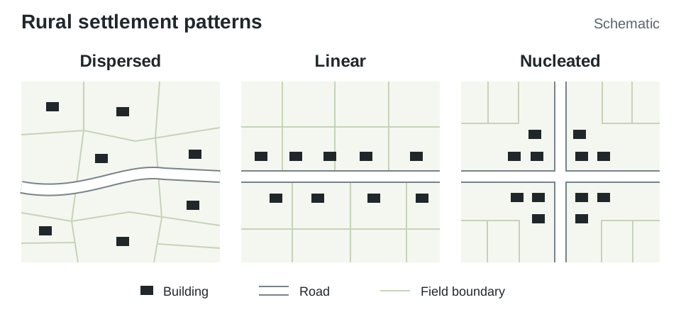
Rural settlement forms distinct shapes across the countryside:
| Pattern | Visual Clues | Reason for Layout |
|---|---|---|
| Dispersed | Scattered, isolated farmhouses across fields | Ireland's most common rural pattern: farmers live directly beside their agricultural land. |
| Linear | Buildings in a line along a road | Easy access to transport, water mains and electricity. |
| Nucleated | Buildings tightly clustered around a junction | Services attract residents, drawing in further shops and housing. |
| No settlement | Large areas with no buildings at all | Steep slopes, exposed uplands or waterlogged bogs. |
Factors Influencing Settlement Origin and Location
Early settlers chose locations that provided essential resources, security and transport connections:
- Water supply and fertile soils: Rivers provided clean drinking water, fish for food and inland transport, while fertile lowland soils supported crops and grazing.
- Flat relief: Lowland areas with widely spaced contours were easier to build on and farm than steep uplands.
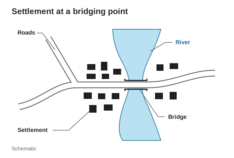
- Bridging points: Shallow river crossings allowed routeways to meet, making them natural sites for trade and markets.
- Nodal points: Route junctions where several valleys or roads meet developed into accessible market towns.
- Defensive sites: High hills or river loops gave settlers advance warning and protection against attack.
| Origin | Clues on Maps and Landscapes | Irish Example |
|---|---|---|
| Early Christian | Monastic ruins, round towers, clon- or mainistir | Clonmacnoise |
| Viking | Sheltered coastal harbours, names ending in -ford or -low | Waterford |
| Anglo-Norman | Stone castles at river bridging points, walled towns | Kilkenny |
Urban Land Use Zones and the CBD
Towns and cities are divided into areas with different land uses, including residential, industrial, open space and commercial zones.
- CBD (Central Business District): The commercial core of a city, containing major department stores, specialist shops, banks, company offices and entertainment venues.
- High land values: Land is most expensive in the CBD because it is the most accessible part of the city, where main roads, bus corridors and rail routes meet. High demand forces land to be used intensively, resulting in multi-storey buildings.
- Outer zones: Factories, retail parks and residential housing estates are built further out in the suburbs, where land is cheaper and larger sites are available.
Urban Change, Dublin, and Globalisation
People move to cities for employment in industry and services, access to third-level colleges and hospitals, and because farm mechanisation has reduced agricultural jobs.
Dublin illustrates how population growth and economic ties drive urban change:
- Primate city: Dublin city and suburbs had about 1.26 million people in Census 2022, roughly five times the population of Cork city and suburbs, Ireland's second city.
- Urban sprawl: Rapid population growth causes housing estates to expand outward continuously onto surrounding rural farmland.
- Commuter towns: High housing costs in the city mean many workers live in commuter towns such as Maynooth, Bray and Navan and travel in to work.
- Urban regeneration: Derelict inner-city brownfield sites, such as the Dublin Docklands, were redeveloped into modern commercial offices and apartments.
- Globalisation: Multinational technology companies locate European headquarters in Dublin, attracting international workers and increasing demand for housing.
Key terms
- Function
- The service a land use provides, such as a school providing education or a shop providing retail.
- Land use
- Any use of land; a school or a factory is an example of a land use.
- Bridging point
- A shallow or narrow point along a river where a bridge can be built easily.
- Primate city
- A city whose population is at least twice as large as the second-largest city in the country.
- Urban sprawl
- The uncontrolled and unplanned outward expansion of a town or city into the surrounding countryside.
- Urban regeneration
- The redevelopment of derelict or rundown urban areas to provide modern housing, offices and services.
Check yourself
What is the most common rural settlement pattern found across Ireland?
Dispersed settlement.
Why is Dublin called Ireland's primate city?
Its population is more than twice the size of Cork, Ireland's second-largest city.
Why are land values highest in a city's Central Business District (CBD)?
It is the most accessible part of the city where major transport routes converge, creating high demand for space.
Give two reasons why people move from rural areas to cities.
For better job opportunities in industry and services, and for access to third-level colleges and hospitals.