

Applied Learning Task 3 (ALT 3), 'Designing a Nature-Based Experience', sits within Strand 4 of Leaving Certificate Climate Action and Sustainable Development (CASD). In this task, students investigate human relationships with the natural world by examining contemporary Irish land-use dilemmas, interrogating power dynamics, analysing qualitative and quantitative environmental data, and communicating findings to specific audiences. Students translate their research into an active, participatory experience that strengthens people's connection to nature and enhances wellbeing. While Applied Learning Tasks are conducted in small groups in class and assessed formatively by your teacher rather than directly marked by the State Examinations Commission (SEC), the investigative methods, data analysis, and design principles taught here are directly examined in the 60% written paper and build the core competencies needed for your 40% coursework Action Project.
The Structure of ALT 3 and the Assessment Framework
Applied Learning Tasks act as practical lenses through which you experience the core concepts of Strands 1, 2, and 3. In ALT 3, the focus centres on how people interact with, govern, and benefit from the living and physical environment.
ALT 3 is defined by four integrated learning outcomes:
- ALT 3.1: analyse contemporary dilemmas related to the use of land or nature in Ireland, considering the power different groups have in determining the outcome.
- ALT 3.2: analyse data (qualitative/quantitative) to identify patterns and relationships.
- ALT 3.3: organise and communicate their research and investigative findings in appropriate ways fit for purpose and audience, using relevant terminology and representations.
- ALT 3.4: design a participatory experience, informed by their research and investigative findings, which enhances peoples' relationships with nature; recognise the benefits of being in and connecting with nature.
Documenting, Reflecting, and Sharing
The specification requires that for every Applied Learning Task, students document, reflect, and share their learning. You should keep a continuous record as you work: research notes, raw survey data, records of decisions changed along the way, and annotated photographs or sketches. At the end of the task, you reflect on what your group achieved against your initial plan, what you personally contributed, and how the local task connects to wider national and global sustainability challenges. Finally, you share the learning with an audience outside your group, such as presenting to another class or publishing a summary for the school community. Sharing turns research into action.
Keep ALT 3 and the Action Project distinct in your mind. ALT 3 is collaborative classroom learning assessed with teacher feedback. The Action Project is an individual digital coursework journal of up to 1,800 words based on the SEC's common brief ('Reducing Ireland's Greenhouse Gas Emissions' for 2027), submitted to your teacher by Friday 12 March 2027 for SEC grading. ALT 3 builds the practical habits of enquiry; the Action Project is where those competencies are formally assessed.
Defining Nature: Commons, Resources, and Ecosystem Services
To evaluate environmental dilemmas fairly, you must understand how the syllabus conceptualises nature. In this subject, nature is considered as:
- The commons: Shared life-support foundations—specifically land/space, soil, water, and air—that belong to no single entity exclusively, sustain collective life, and demand shared stewardship across generations.
- Natural resources: Materials and forms of energy taken from the environment and used for economic benefit, including fossil fuels (peat, gas), minerals and aggregates, timber, and renewable energy sources such as wind and solar.
Dilemmas arise because a single landscape often represents both a commons and a commercial resource at the same time. A river catchment acts as a commons providing drinking water, recreational amenity, and wildlife habitat, while also serving as a resource for agricultural drainage, industrial discharge, or hydropower.
Anthropocentric vs. Ecocentric Worldviews
Underlying environmental conflicts are differing value systems:
- Anthropocentric (Human-Centred): Nature is valued primarily for its practical utility and economic benefit to human society. Success is measured through crop yields, commercial employment, energy security, or infrastructure expansion.
- Ecocentric (Nature-Centred): Nature possesses intrinsic worth. Living species, river catchments, and natural systems have an inherent right to exist, function, and regenerate regardless of their financial or utilitarian value to humans.
Ecosystem Services Framework
When arguing why a habitat matters, evaluate the four categories of benefits people receive from nature:
- Provisioning: Physical products harvested from ecosystems, such as food, timber, fuel, and fresh drinking water.
- Regulating: Natural systems regulating environmental conditions, including carbon sequestration, flood attenuation, water filtration, crop pollination, and local temperature moderation.
- Cultural: Non-material benefits, including physical recreation, mental wellbeing, artistic inspiration, local heritage, and sense of place.
- Supporting: Fundamental ecological processes that underpin all other services, such as soil formation, photosynthesis, and nutrient cycling.
Applying this to a raised bog shows why dilemmas occur: drainage and harvesting prioritise provisioning services (turf for domestic heating), whereas rewetting trades that fuel off to restore regulating services (carbon storage and flood control), supporting services (peat-forming Sphagnum moss), and cultural amenities (biodiversity observation and recreation).
Analysing Contemporary Irish Land-Use Dilemmas (ALT 3.1)
A contemporary dilemma occurs when choosing one land-use option undermines another valid economic, social, or ecological priority. In ALT 3.1, you must analyse real Irish situations and identify who holds the power to decide the outcome—and where that power comes from.
Authentic Irish Case Studies
- Peatland Rewetting vs. Domestic Turbary Rights: Bord na Móna has ceased commercial harvesting to rewet extensive cutaway bogs across the Midlands, transforming degraded peat into active carbon sinks and biodiversity reserves. However, this transition clashes with local households holding traditional turbary rights (legal entitlements to cut peat for domestic fuel), raising concerns over rural fuel poverty, heritage, and local drain water levels.
- Commercial Conifer Plantations vs. Native Woodland: Commercial forestry policy historically incentivised fast-growing non-native monocultures, predominantly Sitka spruce (Picea sitchensis), to support a domestic timber industry and rapid carbon uptake. However, dense conifer stands acidify upland headwaters, reduce light penetration, and support significantly lower biodiversity than native woodland of sessile oak, downy birch, hazel, holly, and alder.
- Agricultural Intensity vs. Freshwater Riparian Buffer Zones: Ireland's livestock and dairy sectors are central to rural livelihoods. Under the EU Water Framework Directive and Ireland's Nitrates Action Programme, farmers must observe buffer zones (setback distances) where slurry and chemical fertiliser cannot be spread beside watercourses. Furthermore, farmers operating under a nitrates derogation are required to fence watercourses to prevent cattle entry, while agri-environment schemes like ACRES pay for planted riparian buffer zones. These measures protect rivers from eutrophication, but they remove productive grazing land and require capital investment.
- Renewable Energy Infrastructure vs. Local Landscape Integrity: Ireland's 2030 climate target is a legally binding 51% reduction in greenhouse gas emissions from 2018 levels. Expanding onshore wind and commercial solar generation is a central policy pathway to reach this target. However, infrastructure proposals frequently face local objections regarding noise, visual intrusion, construction traffic, and the disturbance of sensitive upland peat hydrology.
A Checklist for Analysing a Land-Use Dilemma
This checklist serves as a study aid to structure an analytical answer; it is not a rigid official template:
- Identify the core dilemma: What are the competing demands on this land or water body?
- Map the stakeholders: Distinguish between statutory bodies (NPWS, EPA, local county councils), the national planning appeals body (An Bord Pleanála, being renamed An Coimisiún Pleanála under the Planning and Development Act 2024), commercial bodies, local community groups, and farmers.
- Unpack underlying value systems: Who holds an anthropocentric view focused on economic yields, and who holds an ecocentric view defending habitat integrity?
- Evaluate power dynamics: Identify each group's leverage:
- Statutory and legal power: Legislative planning authorities and EU environmental directives.
- Financial and economic power: Capital assets, ownership of deeds, legal representation, and commercial lobbying.
- Social and democratic power: Community campaigns, local knowledge, and voter pressure.
- Who has no voice: Non-human species and future generations have no vote, no capital, and no legal standing of their own; they rely entirely on proxy representation by NGOs, scientists, or community advocates.
- Identify enablers and blockers: Which forces are accelerating climate and biodiversity solutions, and which are delaying or resisting change?
- Propose fair alternatives: How might a just transition package, community ownership model, or compensatory measure balance environmental protection with local livelihoods?
Fieldwork Methods and Data Analysis: Patterns, Relationships, and Limits (ALT 3.2)
Outcome ALT 3.2 requires gathering and analysing both qualitative and quantitative evidence to understand environmental relationships.
Fieldwork Toolkit and Data Types
- Primary data is information you collect yourself in the field. Useful primary methods include:
- A quadrat to measure plant species richness and percentage ground cover.
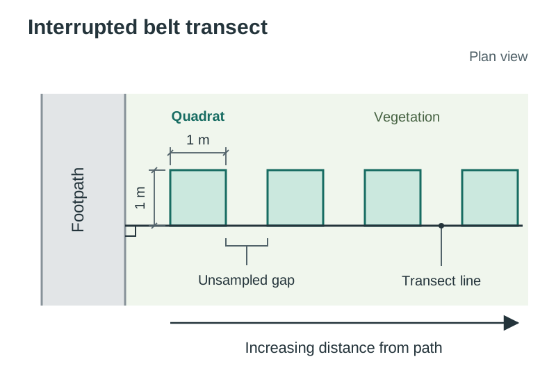
- An interrupted belt transect to examine changes in vegetation with distance from a footpath or water source.
- A Flower-Insect Timed (FIT) Count from the All-Ireland Pollinator Plan: 10 minutes observing a patch of target flowers, counting insect visits.
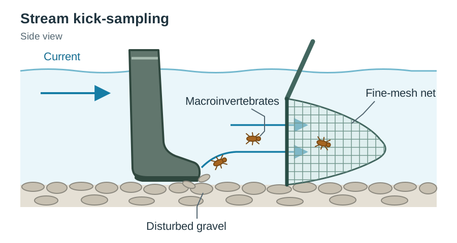
- A timed stream kick-sample (e.g. 2 minutes of disturbing riverbed gravels into a fine-mesh net) to record freshwater macroinvertebrates.
- Physical testing kits: soil pH, soil temperature probes, and water nitrate/phosphate test strips.
- Qualitative fieldwork: open survey questions, short participant interviews, soundscape mapping, and annotated photographs.
- Secondary data is information gathered by external agencies. Authoritative Irish sources include:
- Environmental Protection Agency (EPA): river water quality Q-values, air quality monitoring, and greenhouse gas inventories.
- National Biodiversity Data Centre (NBDC): species distribution maps, threatened species registers, and pollinator monitoring.
- National Parks and Wildlife Service (NPWS): designated habitats (Special Areas of Conservation, Special Protection Areas, Natural Heritage Areas).
- Met Éireann: regional precipitation and temperature trends; Central Statistics Office (CSO): land use and farming statistics; Teagasc: soil maps; GeoHive / Tailte Éireann: historical aerial photography.
Evaluating Secondary Sources and Triangulation
When examining secondary evidence, evaluate its reliability using four questions:
- Who produced the source, and what is their underlying mandate or interest?
- When was the dataset collected? Environmental baselines change rapidly.
- How was the data sampled? Check the sample size, geographic range, and whether figures represent direct measurements or estimated models.
- What voices, viewpoints, or variables are missing from the data?
Triangulation means cross-checking findings using two or more independent methods or sources—for example, comparing your primary stream kick-sample results with the EPA's published biological Q-value for that river reach. When separate sources point to the same pattern, your conclusions are substantially more reliable.
Quantitative Data: Calculating Patterns and Recognising Limits
Field measurements must be converted into clear summary statistics:
The mean () is the sum of all recorded values () divided by the total number of samples ().
Never assume that a mathematical correlation proves direct causation. If wildflower diversity declines within two metres of an asphalt path, physical foot trampling may be a factor, but shaded canopy cover, regular grounds mowing, or compacted limestone hardcore beneath the path may also explain the trend. Always identify limitations: small sample size, seasonal weather anomalies, lack of a control baseline, or self-reporting bias in questionnaires.
Analysing Qualitative Data in Four Steps
Qualitative information provides the reasons and motivations behind human behaviour that numbers cannot capture:
- Gather systematically: Collect short open-ended responses, interview quotes, or field observations using standardised prompts.
- Code the responses: Read the text carefully and apply a brief tag or code to each idea (e.g., 'feels unsafe', 'looks untidy', 'nowhere to sit').
- Group codes into themes: Combine related tags into two or three core themes and tally how many participants raised each theme (e.g., '12 of 18 students cited lack of dry seating').
- Support with representative quotes: Cite a direct quotation that illustrates each theme, and link that insight back to your numerical data.
Limitations of qualitative data: Findings from small, self-selecting groups capture personal attitudes at one specific time; they explain why a local dynamic occurs, but they cannot be generalised to an entire population.
Communicating Findings Fit for Purpose and Audience (ALT 3.3)
Under ALT 3.3, scientific and community research must be communicated using media, language registers, and visual representations tailored specifically to your chosen audience.
| Target Audience | Purpose & Format | Tone & Language Register | Sample Opening Sentence |
|---|---|---|---|
| Local Authority / County Council | Influence municipal park management or planning zoning via a formal 2-page policy brief with GIS habitat maps. | Objective, evidence-based, formal register referencing statutory targets and local development plans. | 'This submission evaluates the mowing regime at [Park Name]; our survey of 20 quadrats recorded 14 pollinator-friendly plant species in unmown margins compared with 3 in mown lawn, and we recommend aligning maintenance with the Council's Biodiversity Action Plan.' |
| School Leadership / Board of Management | Secure permission and resources for a no-mow biodiversity zone or pond using a slide deck and visual summary sheet. | Professional, constructive, action-oriented tone addressing risk management, curriculum links, and costings. | 'We propose establishing a 50-metre native hedgerow corridor on our southern boundary, which will lower grounds maintenance costs, provide an outdoor lab for science, and support our school climate charter.' |
| Local Farming Community | Encourage voluntary uptake of multi-species swards or riparian margins through an illustrated leaflet and discussion workshop. | Respectful, practical, non-accusatory register focused on livestock health, soil structure, and grant supports. | 'Fencing cattle back from our local stream margin and planting native alder creates a natural buffer that intercepts nutrient runoff, protects herd foot health, and qualifies for agri-environmental scheme payments.' |
Designing a Participatory Nature Experience (ALT 3.4)
Outcome ALT 3.4 requires students to 'design a participatory experience, informed by their research and investigative findings, which enhances peoples' relationships with nature; recognise the benefits of being in and connecting with nature'.
A participatory experience is not a passive nature walk or an outdoor lecture. Participants must have agency: they handle equipment, record observations, make decisions, or create something in the natural setting.
Core Design Principles
- Ground the design in prior research findings: Activities must respond directly to an identified ecological or social need. If surveys revealed that peers avoid a woodland because they perceive it as dark or featureless, your activities must intentionally foster sensory curiosity, species familiarity, and comfort.
- Involve active hands-on engagement: Include activities where participants actively interact with nature, such as conducting a 10-minute Flower-Insect Timed Count, sampling soil texture, or undertaking a silent sensory soundscape audit.
- Incorporate reflection and dialogue: Provide structured individual time, such as a 10-minute 'sit spot' where participants sit silently to observe their immediate surroundings, followed by facilitated group dialogue to share observations.
- Address accessibility, inclusion, and safety: Verify step-free routes for mobility access, plan bad-weather contingencies, provide visual/tactile identification guides alongside written sheets, and ensure zero habitat damage by upholding Leave No Trace principles.
- Evaluate outcomes: Collect before-and-after evidence to measure whether the session influenced participants' ecological understanding and emotional outlook.
Nature Connection and Cultivating Wellbeing
Outcome ALT 3.4 requires you to recognise the direct wellbeing benefits of nature connection. This links directly to the Senior Cycle Key Competency of Cultivating Wellbeing and addresses the affective dimension of learning.
Encountering the realities of the climate and biodiversity crises can trigger eco-anxiety, powerlessness, and emotional fatigue. Spending structured time in green spaces (woodlands, meadows) and blue spaces (rivers, lakes, coasts) supports wellbeing across several dimensions:
- Physical Wellbeing: Lowers blood pressure, regulates heart rate, stimulates immune function, and encourages outdoor physical movement.
- Mental and Psychological Wellbeing: Time in natural environments has been shown to lower levels of the stress hormone cortisol and to restore our capacity to concentrate—what environmental psychologists term attention restoration. This directly relieves the cognitive fatigue caused by continuous screen time. Hands-on stewardship builds personal agency, transforming abstract worry into constructive action.
- Social Cohesion and Sense of Place: Collective outdoor tasks build shared purpose and deepen an individual's emotional and cultural connection to their local landscape (sense of place).
- Ecological Stewardship: Direct sensory contact moves conservation from an abstract theory into a lived reality. When individuals discover living macroinvertebrates in clean water or examine rich woodland soil, they build an authentic motivation to protect the commons.
Key terms
- The Commons
- The shared foundations of life—specifically land/space, soil, water, and air—that belong to no single entity exclusively, sustain collective human life, and require shared stewardship across generations.
- Natural Resources
- Materials and forms of energy taken from the environment and used for economic benefit, including fossil fuels (peat, gas), minerals and aggregates, timber, and renewable energy sources such as wind and solar.
- Contemporary Dilemma
- A current conflict over the use of land or nature involving competing economic, cultural, and environmental priorities, where no simple solution satisfies all stakeholders.
- Power Dynamics
- The unequal distribution and exercise of statutory authority, financial resources, political influence, and community organisation among stakeholders contesting environmental decisions.
- Anthropocentric
- A human-centred value system that views nature primarily in terms of its practical utility, economic resource value, and material benefit to human society.
- Ecocentric
- A nature-centred value system asserting that ecosystems, living species, and natural systems possess intrinsic worth and rights to exist, independent of their usefulness to humans.
- Ecosystem Services
- The direct and indirect benefits that healthy ecosystems provide to human society, categorised into provisioning, regulating, cultural, and supporting services.
- Participatory Experience
- An interactive event or activity structured so that participants actively contribute, observe, experiment, measure, or deliberate, rather than acting as passive listeners.
- Triangulation
- The practice of using multiple independent data collection methods or sources to cross-check findings, increasing the validity and reliability of conclusions.
- Turbary Rights
- Traditional, legal rights associated with specific properties entitling holders to cut, harvest, and dry peat turf from an identified parcel of bogland for domestic fuel.
- Riparian Buffer Zone
- A strip of permanently vegetated land planted with native grasses, shrubs, or trees alongside a watercourse to filter sediment and nutrient runoff before it enters freshwater.
- Sense of Place
- The emotional, experiential, and cultural bond that develops between an individual or community and a specific geographic location over time.
- Just Transition
- A framework ensuring that the social and economic costs of shifting to a sustainable economy are shared fairly, protecting vulnerable workers, farmers, and communities.
- Leave No Trace
- A set of outdoor ethics promoting responsible recreation and research to minimise human impact, prevent habitat disturbance, and protect natural environments.
- Analyse
- Study or examine something in detail, break down in order to bring out the essential elements or structure; identify parts and relationships, and interpret information to reach conclusions.
- Design
- Conceive, create, and execute according to plan.
- Examine
- Consider an argument or concept in a way that uncovers the assumptions and relationships of the issue.
- Evaluate
- Collect and examine data or evidence to make judgments and appraisals; describe how evidence supports or does not support a conclusion; identify limitations.
- Reflect
- Consider in order to correct or improve.
Check yourself
What is the official definition of nature in the Climate Action and Sustainable Development specification?
Nature is considered as the commons (land/space, soil, water, air) and, where relevant, natural resources (fossil fuels, minerals, renewable energy sources, etc.).
Give one qualitative and one quantitative method you could use to investigate why people avoid a local woodland.
Qualitative: short open interviews or open questionnaire comments coded into common themes. Quantitative: a timed footfall count at the entrance, or an exit survey using a 1–10 rating scale.
In five soil cores, earthworm counts were 6, 8, 3, 11, and 7. Calculate the mean earthworm count.
Mean = (6 + 8 + 3 + 11 + 7) ÷ 5 = 35 ÷ 5 = 7.0 earthworms per sample.
What is meant by triangulation in environmental data analysis?
Triangulation is the practice of cross-checking findings using two or more independent methods or data sources (such as pairing your own kick-sample with published EPA river Q-values) to increase reliability.
Name two practical adjustments that ensure a participatory nature experience is inclusive.
Selecting a firm, step-free route with resting seating for mobility access, and providing multi-format identification materials (such as large-print pictorial keys or spoken instructions) alongside wet-weather shelter.
How do attention restoration and cortisol reduction explain the wellbeing benefits of nature connection?
Immersion in natural settings lowers circulating levels of the stress hormone cortisol and restores directed attention, relieving the mental fatigue caused by screen exposure.
Are Applied Learning Tasks submitted directly to the State Examinations Commission for grading?
No. ALTs are conducted in small groups in class and assessed by your teacher; the competencies developed are tested in the 60% written exam and apply directly to your 40% Action Project.