

Ordnance Survey (OS) mapwork develops your graphicacy skills to interpret Irish landscapes using coordinates, scale, and symbols. In the Junior Cycle examination, you will calculate distance and area, pinpoint grid references, read the legend, and support landscape explanations with direct map evidence.
Scale and Grid References
Irish OS Discovery Series maps use a scale of 1:50,000, meaning 2 cm on the map equals 1 km on the ground. Each blue grid square has 2 cm sides, covering an area of 1 km².
Ireland is divided into 25 National Grid subzones of 100 km x 100 km, each identified by a letter. Vertical grid lines are eastings (numbering increases towards the east) and horizontal lines are northings (numbering increases towards the north).
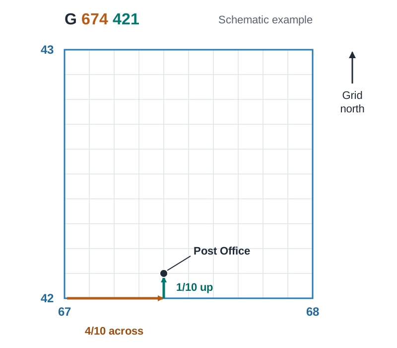
To write a grid reference, follow the LEN rule: Letter, Easting (in the door along the bottom), Northing (up the stairs):
- Four-figure references give the 1 km² square: subzone letter, easting line to the left, northing line at the bottom (for example, G 69 46).
- Six-figure references pinpoint a feature to within 100 metres by estimating tenths across and tenths up.
- Read the reference from the symbol itself, not from the name printed beside it.
- Example: the Post Office in subzone G sits 4 tenths past easting 67 and 1 tenth above northing 42, giving reference G 674 421.
Reading the Legend and Direction
The legend printed with the map explains every symbol; always check it before writing an answer.
- Roads are classified by letter: M for motorway, N for national road (such as the N15), R for regional road, and thin white lines for local roads.
- Railway lines are marked with small cross-ticks, while disused railways are dashed.
- Common symbols include churches, graveyards, youth hostels, caravan parks, and antiquities (historic monuments).
- Each symbol reveals a land use and its function, such as a school providing an educational function or a church providing a religious function.
Grid north points to the top of the map. Use eight compass directions (N, NE, E, SE, S, SW, W, NW) to describe location. A river always flows downhill from high ground towards lower ground or the sea; check spot heights and contour values to see which end is higher.
Measuring Distance, Area, and Relief
To measure distance, use a straight strip of paper and the map's linear scale bar:
- Straight-line distance: mark both points on the paper edge, line the first mark up with 0 on the scale bar, and read the kilometres.
- Curved distance: mark the start on the edge of your paper, then turn the paper at each bend so the edge follows the road, marking each turn, until you reach the end point.
- Regular areas: count the number of squares wide, multiply by squares high, and write the answer in km².
- Irregular areas: count each full square, add squares that are half or more covered, and ignore squares less than half covered.
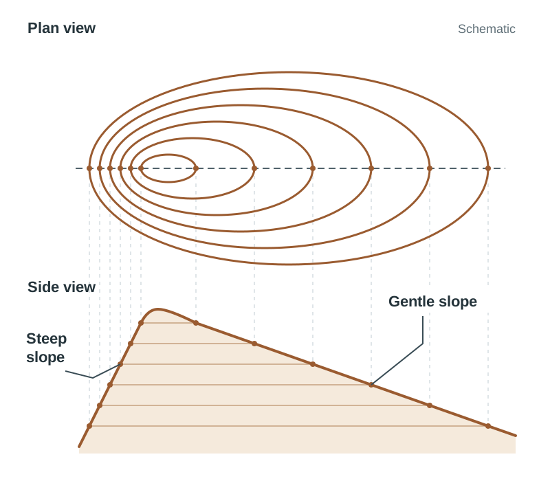
Height is shown using brown contour line markings (tightly packed contours show steep slopes; widely spaced contours show flat or gentle land), a spot height (a black dot with its height in metres), or a triangulation pillar (a small triangle marking a surveyed high point).
Sketch Maps and Map Evidence
Sketch maps can be set from an OS map or an aerial photograph.
- Draw a frame with roughly the same shape as the map or photograph, a little smaller than the original. Light guide lines across the middle help you place features in the right positions.
- Marks are for showing and labelling each feature the question names, in the right relative position. Add a title, a north arrow and a key so your labels are clear.
When a question asks you to explain settlement, transport, or tourism using map evidence, separate marks are given for the statement, the map evidence and the explanation, so always write all three.
Key terms
- Scale
- The ratio between a distance on a map and the actual distance on the ground, such as 2 cm representing 1 km.
- Eastings
- Vertical grid lines on an OS map that increase in value as you move eastwards.
- Northings
- Horizontal grid lines on an OS map that increase in value as you move northwards.
- Grid Reference
- A coordinate containing a subzone letter, easting, and northing used to locate a square or exact feature on a map.
- Legend
- The key supplied with a map that illustrates and defines the symbols, lines, and colours used.
- Contour Line
- A brown line joining places of equal height above sea level.
- Spot Height
- A black dot with a number showing the exact measured elevation in metres at that specific point.
- Function
- The specific service or activity provided by a land use, such as religious worship at a church or recreation at a park.
Check yourself
What real-world distance does a length of 6 cm represent on a standard 1:50,000 OS Discovery map?
3 km, because every 2 cm on the map represents 1 km on the ground.
A river has a spot height of 310 m near one end and enters an inlet at the other. In which direction does the river flow?
From the high ground towards the sea, because water always flows downhill.
How can you tell whether a hillside is steep or gentle using contour lines?
Tightly packed contour lines indicate a steep slope, while widely spaced contours show a gentle or flat slope.
What type of road is indicated on an Irish OS map by the letter N, such as the N15?
A national road.
Which squares do you include when estimating the area of an irregular lake on an OS map?
Count all fully covered squares and all squares that are half or more covered, ignoring any squares less than half covered.