

An aerial photograph captures a real-world view of the landscape from above, showing physical features and human activity without map symbols. In the Junior Cycle exam, you will locate features, classify settlements, explain reasons for development using photographic evidence, identify seasons, and draw simple sketch maps.
Oblique and Vertical Photographs
Aerial photographs are taken from an aircraft, drone, or satellite. There are two main types used in the exam:
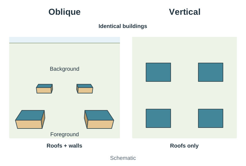
- Oblique aerial photographs are taken at an angle to the ground. They show the fronts and roofs of buildings, and they often include the horizon. Because of the camera angle, scale varies across the view: features in the foreground look much larger than identical features in the background.
- Vertical aerial photographs are taken looking straight down from directly overhead. They show building roofs and road layouts in a flat bird's-eye view, without any horizon. Scale remains consistent and uniform across the whole photograph, making it easier to compare sizes.
You cannot measure accurate ground distances directly off an oblique photograph because of perspective distortion.
Locating Features Using 3 × 3 Grids
To locate features accurately, divide the photograph into nine equal zones using a three-by-three grid. The terms you use depend on the type of photograph.
For oblique photographs, describe position and depth:
| Left background | Centre background | Right background |
|---|---|---|
| Left middleground | Centre middleground | Right middleground |
| Left foreground | Centre foreground | Right foreground |
For vertical photographs, use cardinal compass directions:
- Top row: North West, North, North East
- Middle row: West, Centre, East
- Bottom row: South West, South, South East
Never mix the two systems. Do not use compass points on an oblique photograph, and never write foreground or background for a vertical photograph.
Settlement, Economic Activity, and Location Factors
Exam questions often ask you to interpret human activity and justify your answer using visual evidence.
Rural or Urban Settlement
State your choice clearly, then give three separate pieces of visual evidence:
- Urban evidence: rows of terraced houses or housing estates, multi-storey buildings, heavy traffic, shopping centres, large car parks, and street lighting.
- Rural evidence: scattered one-off houses, farmland divided into fields, farmyards with barns, narrow roads, and patches of forestry or bog.
Explaining Location from Evidence
When explaining why a factory or town developed at a particular site, always name the factor, explain how it helps, and quote what you see in the photograph:
- Flat, low-lying land: cheap and easy to build on (level ground in the foreground).
- Transport links: movement of goods and people (a wide main road, railway line, bridge, or port).
- Labour and market: nearby customers and workers (large housing estates beside the site).
- Water supply: domestic and industrial use (a river or lake running past the settlement).
Economic sectors leave visible clues: livestock and ploughed fields show primary activity, factories show secondary activity, and shops or schools show tertiary activity.
Seasons, Sketch Maps, and OS Maps
Identifying the Season
Support your answer with clear physical clues. Deciduous trees in full green leaf, fields of ripe yellow crops, cut hay bales, and grazing cattle point to summer. Bare branches, ploughed soil, and chimney smoke point to winter. Short shadows can support summer, but never rely on shadow length alone.
Sketch Maps
A sketch map is a simplified overhead drawing of a photograph. Keep it clear:
- Draw a neat rectangular frame using a ruler.
- Lightly divide the frame into a 3 × 3 grid to guide feature placement.
- Draw the requested features as flat overhead shapes, positioning and labelling each one accurately.
Cross-Referencing with OS Maps
An OS map of the same area provides place names, heights, and true scale. To find a true distance shown on an aerial photograph, locate both points on the OS map and measure them with the map's linear scale.
Key terms
- Aerial photograph
- A photograph of the Earth's surface taken from above by an aircraft, drone, or satellite.
- Oblique aerial photograph
- A photograph taken at an angle, showing the fronts of buildings and varying scale from front to back.
- Vertical aerial photograph
- A photograph taken from directly overhead, showing a flat plan view with uniform scale.
- Graphicacy
- The ability to read, interpret, and construct visual images such as maps, photographs, and charts.
- Land use
- The purpose for which a piece of land is used, such as residential, commercial, or agricultural.
- Function
- The specific service a land use provides, such as education in a school or worship in a church.
- Sketch map
- A simplified, overhead plan drawing that shows and labels selected features from a map or photograph.
Check yourself
Which type of aerial photograph has an uneven scale where foreground objects look larger than background objects?
An oblique aerial photograph.
What is the difference between land use and function?
Land use is how land is used, such as residential, while function is the service it provides, such as housing.
What grid location term describes the bottom-right section of an oblique aerial photograph?
Right foreground.
State two pieces of photographic evidence that prove a settlement is urban.
Dense housing estates built close together and large commercial car parks.