

Climate is the average pattern of weather in an area measured over a long period, usually at least 30 years. For Junior Cycle Geography, you need to classify global climate types, explain the geographical factors shaping Ireland's climate, interpret climographs, and connect climate to human life.
Classifying Global Climates
The world is divided into three main climate zones — hot, temperate and cold — based on temperature and rainfall.
| Zone | Climate Type | Temperature and Rainfall | Example Location |
|---|---|---|---|
| Hot | Equatorial | Hot (27°C) and wet all year; over 2,000 mm rain | Amazon Basin |
| Hot | Hot Desert | Scorching days, cold nights; under 250 mm rain | Sahara Desert |
| Temperate | Warm Temperate Oceanic (Mediterranean) | Hot, dry summers (around 30°C); mild, damp winters | Southern Spain, Malta |
| Temperate | Cool Temperate Oceanic | Mild winters (5°C), cool summers (15°C); rain in all seasons | Ireland |
| Cold | Boreal (Taiga) | Short cool summers, long cold winters (often below −15°C); low precipitation | Sweden, Siberia |
| Cold | Tundra | Winters well below freezing (often around −20°C), brief cool summers near 5°C; under 250 mm rain | Lapland, Northern Canada |
Factors Shaping Ireland's Climate
Ireland has a cool temperate oceanic climate, which means mild winters, cool summers, and plenty of rainfall throughout the year. Several factors explain these conditions:
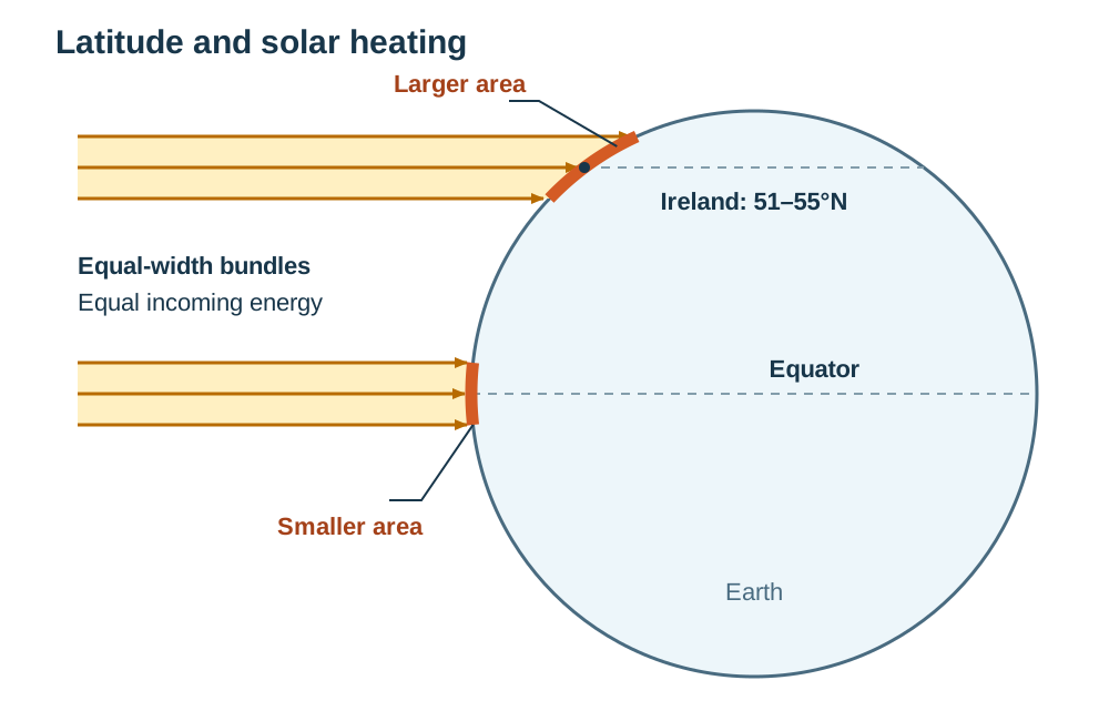
- Latitude: Ireland lies about 51°N to 55°N, far from the equator. The sun's rays strike at a low angle here, so the same heat is spread over a larger area of ground. This gives us cool summers rather than hot ones. The south-east is nearest the equator, so it is our sunniest, warmest region.
- Altitude: Temperature falls by about 1°C for every 100 m of height, so upland areas such as the Wicklow Mountains are colder, and keep snow longer, than the lowlands around them.
- Distance from the sea: The sea heats up and cools down more slowly than land. Because nowhere in Ireland is more than about 110 km from the sea, winters are mild and summers are cool everywhere, with a small annual temperature range.
- North Atlantic Drift: This warm ocean current flows from the Gulf of Mexico across the Atlantic to Ireland's west coast, warming coastal waters and keeping western sea ports ice-free all winter.
- Prevailing winds: Our most frequent winds blow from the south-west across the warm Atlantic, collecting moisture and bringing mild, damp air that moderates temperatures.
- Air masses: Cold polar air meets warm tropical air over Ireland. When these contrasting bodies of air collide, frontal depressions form, bringing overcast skies, wind, and rain.
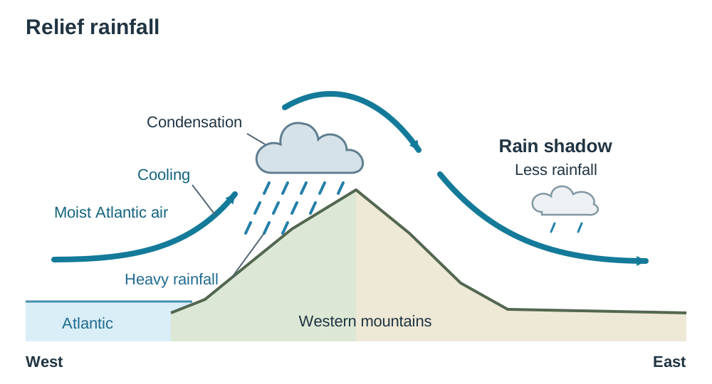
- Relief: Western mountains force moist Atlantic air to rise, cool, and condense, causing heavy relief rainfall on western slopes and leaving eastern areas drier in the rain shadow.
Reading Climographs and Human Connections
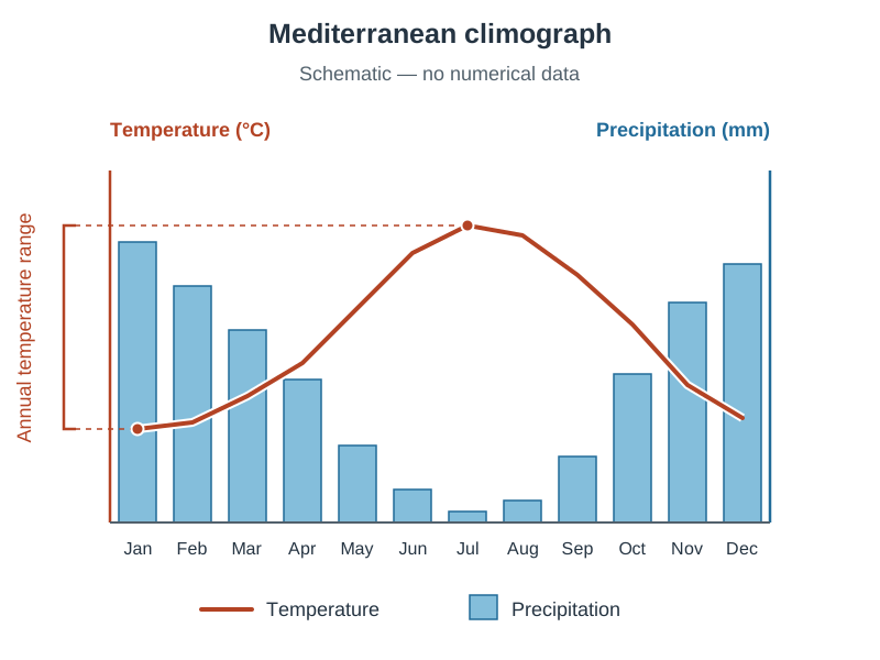
A climograph is one graph that shows a place's average monthly temperature and rainfall, using two different scales (one on each side).
Temperature is shown as a line, read from the axis labelled °C. Precipitation is shown as bars, read from the axis labelled mm. Always check which side of the graph each axis is on before reading a value.
Annual temperature range = warmest month's average temperature − coldest month's average temperature.
Climate affects how people in a region earn a living, where they live, and how they affect the environment:
- Agriculture: Mild temperatures and regular rain give Ireland a long grass-growing season of nine to ten months, perfect for dairy and beef cattle. However, slurry and chemical fertiliser run-off can pollute local rivers.
- Tourism and settlement: Warm Mediterranean summers support a large tourism industry based on beach holidays, and pleasant climates attract retirees and workers to move in. However, the rush of summer visitors puts pressure on local water supplies in the driest months.
Key terms
- Climate
- The average pattern of weather in an area measured over a long period, usually at least 30 years.
- Weather
- The day-to-day state of the atmosphere at a particular time and place.
- North Atlantic Drift
- A warm ocean current that flows from the Gulf of Mexico across the Atlantic to Ireland's west coast, keeping our winters mild and ports ice-free.
- Prevailing Winds
- The most frequent wind direction experienced in a region; in Ireland, these are south-westerly winds.
- Air Masses
- Large bodies of air that have similar temperature and moisture characteristics throughout.
- Relief Rainfall
- Rain formed when warm, moist air is forced to rise over high mountains, cooling and condensing into cloud.
- Climograph
- A single dual-axis graph displaying a location's monthly average temperature as a line and monthly precipitation as bars.
- Annual Temperature Range
- The difference between the warmest month's average temperature and the coldest month's average temperature.
Check yourself
What is the name of Ireland's climate type?
Cool temperate oceanic climate.
Why is the top of a 1,000-metre mountain roughly 10°C colder than sea level?
Because air temperature decreases by about 1°C for every 100 metres of altitude.
A station records an average July temperature of 16°C and a January temperature of 6°C. What is its annual temperature range?
10°C (16°C − 6°C = 10°C).
Which warm ocean current keeps Ireland's western ports ice-free during winter?
The North Atlantic Drift.
Why does the west coast of Ireland receive significantly more rainfall than the east coast?
Moist south-westerly winds hit western mountains, forcing air to rise and creating relief rainfall.